Foggy and damp Saturday around Philadelphia region before temperatures rise. Here's the weather forecast.
Saturday is a repeat of Friday with gray and damp conditions. Temperatures will hover in the 40s during the day and rise into the 50s in the evening. The high will occur overnight, with the temperature reaching nearly 60 degrees at midnight.
A dense fog advisory is in effect for the Jersey Shore, Poconos and southern Delaware through 3 p.m.
Saturday night, showers and isolated non-severe storms will roll through ahead of a warm front between 11 p.m. and 2 a.m.
Turn your clock ahead 1 hour before going to bed. Daylight Saving Time begins at 2 a.m. Sunday. It's also a good time to change the batteries in your smoke and carbon monoxide detectors.
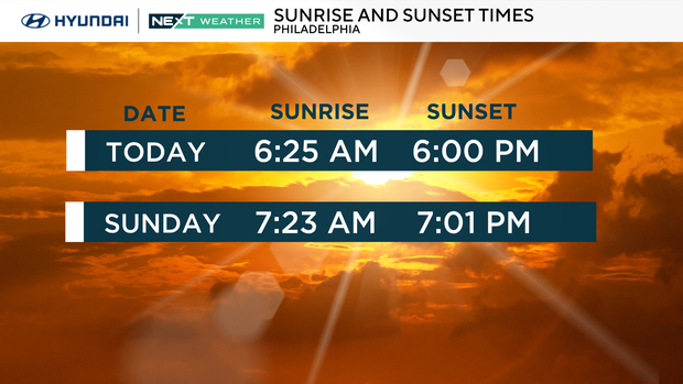
Sunrise on Sunday will be at 7:23 a.m. and skies will be cloudy with isolated early morning showers. Temperatures will reach the mid 60s.
A weak cold front passes the area in the afternoon with more showers possible, especially from I-95 eastward. By evening, skies will begin to clear with a chance of seeing the sun before sunset which is at 7:01 p.m.
NEXT big change
Here comes the warmth and sunshine!
Tuesday and Wednesday will be sunny with highs near 70 on Monday and in the upper 70s Tuesday.
On Wednesday we will reach the mid-70s and chase the old record high of 74 set in 2021. Skies will be cloudy that day with a chance of showers mainly in the evening.
By Thursday temperatures fall throughout the day from the 60s to the 50s. You'll also need an umbrella with persistent rain showers throughout the day.
We'll be back to the 40s by Friday with clouds.
Severe storm threat in western Pennsylvania
Severe storms are likely today and tonight along a line from Western Pennsylvania and the Ohio Valley to Dallas.
Large hail, damaging winds, and tornadoes are possible with these storms.
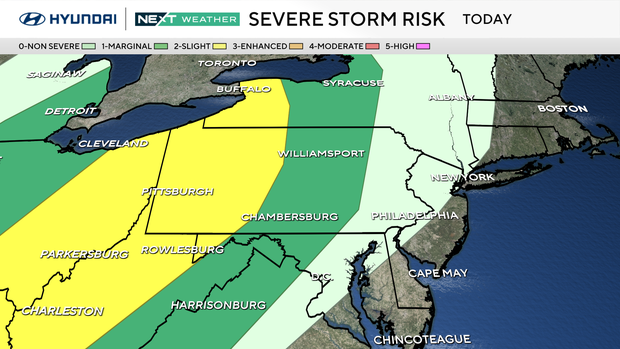
This line of storms weakens before reaching the Philadelphia area and arrives between 11 p.m. and 2 a.m. with scattered showers and isolated rumbles.
Here's your 7-day forecast:
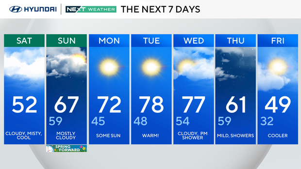
Saturday: Cloudy, misty and cool. High 52
Sunday: Mostly cloudy. High 67, Low 59
Monday: Some sun. High 72, Low 45
Tuesday: Warm. HIgh 78, Low 48
Wednesday: Clouds, PM showers. High 77, Low 54
Thursday: Mild, showers. High 61, Low 59
Friday: Cooling down. High 49, Low 32


