Hot and humid Thursday with chance of stray storm. Here's the weather forecast.

Dress comfortably as the heat is back in the Philadelphia region. Thursday's weather will be hot and humid with highs in the low 90s and feeling like the mid-90s.
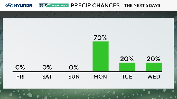
There will also be isolated showers and storms. The risk of any widespread severe storms has been lowered, but any storm that does develop could briefly turn severe with damaging winds.
Speaking of wind, it will be breezy with a southwest wind gusting 25-40 mph this afternoon.
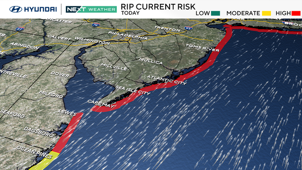
There is also a high rip current risk at the Jersey Shore and Delaware beaches.
NEXT big weather change
The weather will be great for the 2026 Men's World Cup Match on Friday, as well as Father's Day on Sunday!
It should be mostly clear with temperatures in the upper 70s as Haiti and Brazil face off at 8:30 p.m.
Speaking of Sunday, summer officially begins on Sunday, June 21, at 4:24 a.m., even though we've already had three heat waves.
Monday's World Cup game between France and Iraq looks cloudy, warm and humid with scattered thunderstorms.
Here's your 7-day forecast:
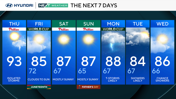
Thursday: High 94, low 71.
Friday: AM shower. High 85, low 72.
Saturday: Sunny. High 87, low 67.
Sunday: Mostly sunny. High 87, low 65.
Monday: Thunderstorms likely. High 88, low 67.
Tuesday: Mostly sunny. High 84, low 67.
Wednesday: Partly sunny. High 86, low 66.


