Tracking heavy rain in Philadelphia region Sunday that could cause flash flooding. Here's the weather forecast.


Sunday in the Philadelphia region looks wet, especially later in the day and at night, with a couple of rounds of rain moving through.
After clouds and spotty sprinkles early in the day, south winds are ushering in plenty of moisture. Although it will be near 80, which is 10 degrees cooler than Saturday, it will also feel much more humid.
Pockets of heavy rain with isolated storms develop later Sunday afternoon and evening. Flash flooding is possible with any storm producing several inches of rain.
For areas south and east of the city, there is a low-end severe threat with any storm, and isolated damaging wind gusts are the main concern.
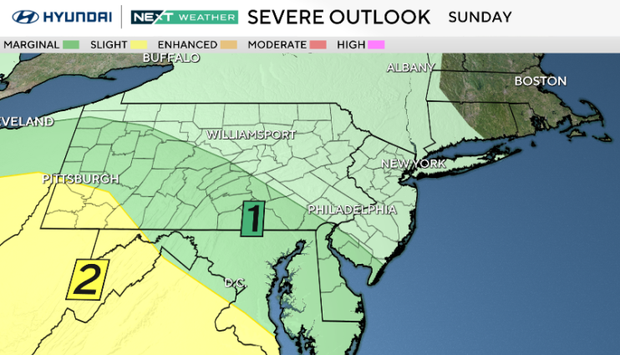
The heaviest rain is likely Sunday evening into overnight, when 1–2 inches with locally higher amounts could lead to localized flash flooding, especially in urban and poor drainage areas. The severe threat is limited overall, but a few stronger storms are possible across southern New Jersey and Delaware closer to the warm front.
NEXT big weather changes
Following Sunday's rain, there may be a few showers and isolated storms to start your Monday.
Otherwise, it will be a summer-like week with the return of sunshine and highs in the upper 80s to low 90s Tuesday and Wednesday.
Unfortunately, the week will end wet with another chance of showers and storms as a cold front approaches Thursday into Friday.
The timing of the storms and any severe or flooding threat remain uncertain.
Behind that front, cooler air should arrive for next weekend, with temperatures roughly 5 degrees lower than midweek.
Here's your 7-day forecast:
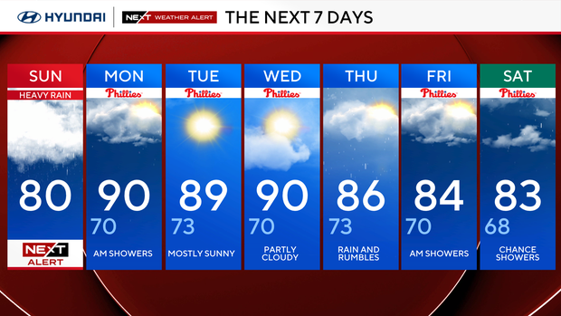
Sunday: NEXT Weather Alert for heavy rain. High 80, Low 71
Monday: Clearing skies. High 90, Low 70
Tuesday: Mostly sunny. High 89, Low 73
Wednesday: Nice day. High 90, Low 70
Thursday: Chance of rain. High 86, Low 73
Friday: Rain and rumbles. High 84, Low 70
Saturday: Chance of showers. High 83, Low 68
Get the latest weather info on the CBS News Philadelphia app.


