Remnants of Hurricane Isaias move out of Philly region Monday as sunshine returns. Here's the weather forecast.

The remnants of Hurricane Isaias will finally move out on Monday after dousing the Philadelphia region with soaking rain all day Sunday.
After Sunday's soaking rain, Monday started with plenty of low clouds, some patchy fog and a few lingering showers. Temperatures are in the upper 50s around Philadelphia, with dewpoints in the 50s, so the air is still quite damp.
The good news is that the rain is moving out, and sunshine will return this afternoon.
As the remnants of Isaias pull northeast, northerly winds will help sweep out lingering moisture. Clouds should gradually break through late morning and midday, with some sunshine developing Monday afternoon. Temperatures rebound nicely into the lower 70s.
Also, watch for standing water and lingering flooding near creeks and streams. Even after the rain ends, water levels can remain elevated for several hours afterward.
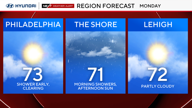
At the shore, we have one more round of minor tidal flooding to get through. Coastal flood advisories remain in effect through 2 p.m. for much of the Jersey Shore and Delaware beaches. Water levels remain elevated due to the persistent onshore flow associated with Isaias, and some back-bay communities could see minor flooding around this morning's high tide.
Conditions improve later Monday as winds turn more northerly and water levels gradually subside. The ocean will still be rough, though, so this isn't a great day for swimming or boating.
Monday night looks quiet, with partly cloudy skies and temperatures dropping into the upper 50s around Philadelphia.
NEXT big weather changes
Our next big change actually comes in two parts: a brief warmup through Wednesday, followed by a much stronger push of fall air heading into the weekend.
First, the remnants of Isaias continue pulling away from the Mid-Atlantic Monday, allowing our weather pattern to reset.
A broad ridge of high pressure to our south will help bring milder air back into the region over the next couple of days. Temperatures climb into the upper 70s Tuesday, and we could be flirting with 80 degrees again Wednesday. Humidity will also increase slightly, with dew points climbing back into the upper 50s and lower 60s. It won't feel oppressively humid, but you'll notice a difference from the crisp, dry air we enjoyed last week.
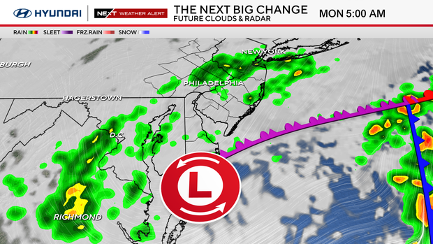
Tuesday looks like a really nice day overall, with a mix of sun and clouds and plenty of dry time for outdoor plans. A weak cold front approaches Tuesday night into Wednesday, bringing a small chance for a few showers. At this point, though, moisture looks limited, and neither day appears particularly wet.
Wednesday could be the warmest day of the week, with temperatures approaching 80 in Philadelphia and some spots potentially climbing into the lower 80s. That front eventually slips south of the region Wednesday night, allowing cooler and drier air to move in Thursday.
Thursday looks beautiful, with sunshine, lower humidity and highs in the upper 60s.
But then comes a much bigger change.
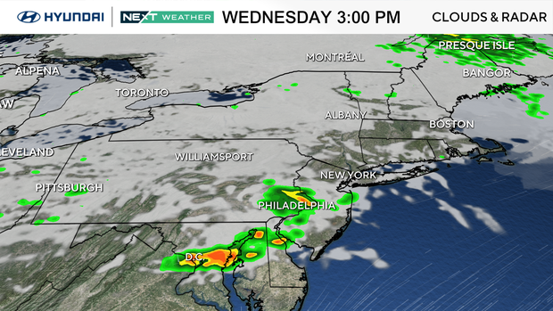
A strong upper-level trough will dig into the Northeast late this week, bringing a sharp drop in temperatures and some very gusty winds. An intensifying area of low pressure tracking through Canada will drag a strong cold front across our region Friday. Showers could develop as early as Thursday night, with our best chance for more widespread rain coming Friday. The exact timing remains uncertain, but this appears to be a relatively progressive system rather than another prolonged rainfall event.
There could be some gusty winds accompanying the frontal passage, especially Friday afternoon and evening.
And behind that front, we're looking at a serious shot of October chill.
Temperatures may struggle to get out of the 50s on both Saturday and Sunday, making this one of our coolest stretches of weather so far this season.
It will also be windy, with a tight pressure gradient developing between the departing storm system and high pressure building in from the west. That means even if we see plenty of sunshine over the weekend, it could feel considerably colder than the thermometer suggests. Saturday in particular looks blustery, with highs only in the upper 50s and a gusty northwest wind. Sunday may be even cooler, with highs in the mid-50s.
Overnight lows could drop into the 30s in some of our colder suburbs by Sunday night, although it's still too early to determine whether frost will become a concern.
So after a very wet weekend, we get a few days of improving weather and a brief warmup before the pattern changes dramatically again.
The bottom line: we're drying out Monday, warming up through Wednesday, then trading the 80-degree weather for highs in the 50s by the weekend.
Here's your 7-day forecast:
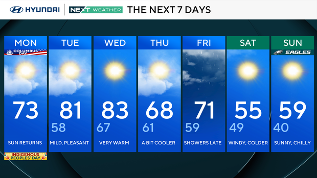
Monday: Sun returns. High 73, Low 60
Tuesday: Mild pleasant. High 81, Low 58
Wednesday: Very warm. High 83, Low 67
Thursday: A bit cooler. High 68, Low 61
Friday: Showers late. High 71, Low 59
Saturday: Windy cooler. High 55, Low 49
Sunday: Sunny, chilly. High 59, Low 40
Get the latest weather info on the CBS News Philadelphia app.


