Some sun Friday in Philadelphia region before temps drop and snow arrives this weekend. Here's the forecast.

Friday in the Philadelphia region will be another milder day with some sun before temperatures drop over the weekend as a snowstorm hits the Delaware Valley.
A cold weather advisory will be in effect in the Philadelphia area Saturday morning as wind chills will be below zero. This Arctic cold will set up the conditions for Sunday's snowstorm. Everyone will receive heavy snow before sleet falls.
NEXT big weather change: snow Sunday morning
A winter storm warning has been issued for the entire Philadelphia area. This alert will take effect at 7 p.m. Saturday and continue through 1 p.m. Monday.
Right now, here's how the timeline is shaping up for Sunday.
- 1 a.m. – 4 a.m.: Snow begins south and east of the city across southern Delaware and far South Jersey.
- 3 a.m. – 6 a.m.: Snow begins across the I-95 corridor, Philly, interior South Jersey, and Chester, Delaware, New Castle, lower Montgomery, and lower Bucks counties.
- 5 a.m. – 8 a.m.: Snow begins for upper Montgomery, Bucks, Berks, Lehigh Valley, and Poconos.
The European Model (ECMWF) has snow beginning around midnight Saturday and lasting through pre-dawn Monday morning. With light snow showers through early Monday morning.
The American Model (GFS) has snow beginning after midnight Sunday morning and lasting through Monday afternoon. With light snow showers into the evening.
Snowfall will be light at the start, very early Sunday morning and increase through the morning.
The storm will intensify by late morning into early afternoon. That is when the heaviest snowfall will occur.
There may be some blowing and drifting snow throughout the day on Monday, complicating travel and snow removal.
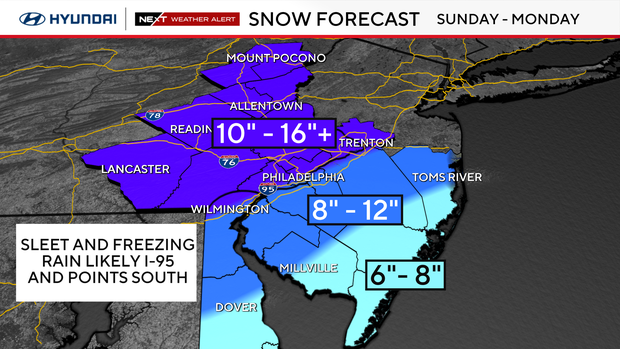
How much snow will Philadelphia get?
If storm tracks farther offshore, there will be heavy snow with little or no sleet or freezing rain.
- 10 – 16+ inches: Areas along I-95, including Philly, Wilmington, Trenton, South Jersey, Chester, Delaware, Montgomery, Bucks counties.
- 10 – 12 inches for interior South Jersey, Lehigh Valley, Berks counties.
- 8 – 10 inches for the Shore and southern Delaware.
If storm tracks closer to the Shore, there will be lower snow totals and more sleet and freezing rain.
- 8 inches – 12 inches: Areas along I-95, including Philly, Wilmington, Trenton, and interior South Jersey, and northern Delaware, South Jersey, Delaware, Montgomery, Bucks counties.
- 10 inches – 16 inches: Chester, Delaware, Montgomery, Bucks, Berks, Lehigh Valley, and Poconos
- 4 inches – 8 inches: For the Shore and southern Delaware.
The last time Philadelphia saw a 6-inch+ snowfall was 7.5 inches on January 29, 2022.
The last time Philadelphia saw a 12-inch+ snowfall was 22.4 inches on January 22-23, 2016.
The last time Philadelphia saw more than 24-inch+ of snow was 28.5 inches on February 5 and 6, 2010.
Prepare for possible impacts of this storm
There's potential for ice accumulation on power lines and tree limbs with this storm.
Possible impacts could include power outages, airport cancellations, train delays, dangerous roads and downed trees. Be prepared for cancellations to religious services, health appointments, fitness or educational programs Sunday and Monday and possibly beyond.
School delays and closings are highly likely on Monday, Jan. 26.
Temperatures will plummet Monday through the middle of next week, with highs in the low 20s and overnight lows dipping to single digits and below zero. So, plan on this snow sticking around through the end of the month.
The best advice is to stay with the NEXT Weather team for frequent updates each day to plan and prepare for the weekend. Have the shovels and ice melt ready. This could be the biggest snow of the season.
Sleet and freezing rain possible on top of heavy snow
The wild card in this forecast is the potential of a wintry mix or sleet that could set up closer to Philadelphia later on Sunday. Any sleet could cut snowfall totals, but where the precipitation stays all snow, it will pile up quickly.
If we get freezing rain on top of 6 or more inches of snow, that could lead to even greater concerns, like power outages.
At some point in the evening, a layer of warm, moist air will be drawn into the storm and there may be a change to sleet and freezing rain from I-95 to the Shore and across Delaware.
This will fall on top of already high amounts of snow. There may even be a period of rain on the beaches.
The question is, how much and for how long there will be any sleet/freezing rain. This could make the difference between 6-8" of snow or 12-16" of snow.
If the center of the storm tracks closer to the Jersey Shore, we will see more sleet and freezing rain. The snow totals would be on the lower side of our forecast.
If the storm tracks 50-100 miles farther offshore, we will see mainly all snow and little if any sleet/freezing rain. The snow totals would be the high side of the forecast.
Where to find warming centers around Philadelphia
Philadelphia has activated an Enhanced Code Blue due to the extremely cold temperatures. The city activates an "enhanced" alert when a Code Blue lasts more than three nights in a row.
Because of the enhanced alert, the Office of Emergency Management has opened multiple warming centers throughout the city. The centers are free and open to the public.
People who need help or see someone in need of help during this cold weather event can also call 215-232-1984.
Bucks County issues a Code Blue whenever temperatures drop below 20 degrees, but could also issue the alert based on other cold-weather factors.
Information about shelter openings can be found on the Housing Link website.
Residents who need temporary shelter, food and clothing during the winter can call 211 or text their zip code to 898-211 for immediate assistance.
During a Code Blue, residents in need of shelter are encouraged to visit one of Delaware County's weather advisory relief centers.
During a Code Blue, the county has additional resources for people experiencing homelessness, including access to temporary warming shelters, food and clothing.
Anyone who needs help with temporary shelter during the cold can call the Your Way Home Call Center at 610-278-3522.
New Jersey
Active Code Blue declarations are listed by county on New Jersey 211's website. The site also includes a list of available warming centers in each county.
Delaware
The Delaware Department of Health and Social Services has opened eight warming centers across the state through Jan. 21. A list of warming centers in each county and their addresses is posted online.
Here's your 7-day forecast:
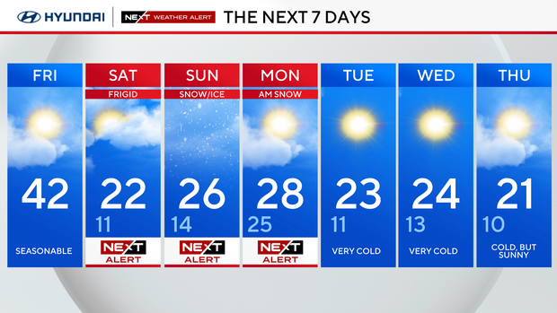
Friday: Some sun. High 44, Low 29
Saturday: NEXT Weather Alert frigid temps. High 19, Low 13
Sunday: NEXT Weather Alert for snow. High 22, Low 14
Monday: NEXT Weather Alert snowstorm ends. High 26, Low 21.
Tuesday: Very cold. High 23, Low 11
Wednesday: Cold but sunny. High 28, Low 17
Thursday: Staying cold. High 27, Low 16


