Blizzard, winter storm warnings in effect, 8-14 inches of snow possible in Philadelphia with more at the shore


Blizzard and winter weather warnings have been issued as a coastal, nor'easter-style snowstorm bears down on the Philadelphia area and Jersey Shore Sunday afternoon and into Monday.
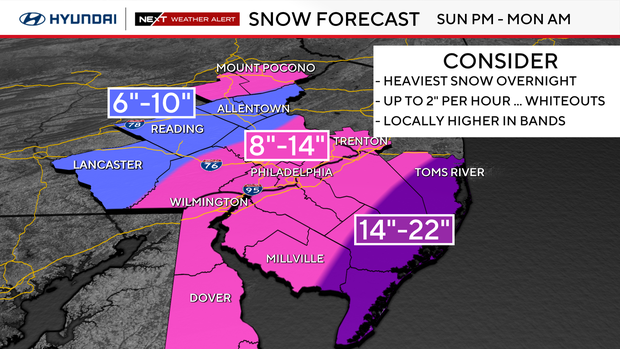
This storm could drop up to 8-14 inches of snow in Philadelphia, with even more snow possible along the coast.
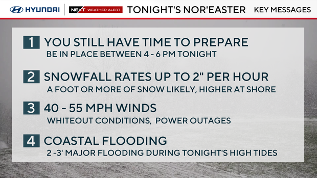
We've issued a NEXT Weather Alert for this heavy snow, with potential for high winds and coastal flooding as well. Officials are warning you to stay home Sunday night and only travel if it is an emergency, as there could be whiteout conditions that make travel very dangerous.
Power outages are also possible due to the coming snow and wind.
The NEXT big change: what to know about the winter storm
This storm is a potential "bomb cyclone," meaning it could experience a large drop in pressure and thus intensify.
It is spinning up as it rounds the bottom of a deep trough in the southeast, then exits the Carolina coast and heads north along the coastline, nor'easter style.
All week, your NEXT Weather team has been closely watching the storm's track, and models were in disagreement about whether it would track closer to land, or more offshore — the closer to land, the more snow we get.
At this point, the storm looks to tuck in closer to our coastline and "bomb out" southeast of Delaware. Some call this a "winter hurricane."
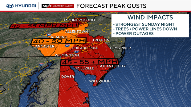
The rapid intensification will create strong winds, heavy snow and up to 2 inches of snow per hour.
This will be a warmer storm with temperatures above freezing much of the day, even in the 40s at the Shore. But temperatures will fall to near freezing by evening.
Snow can fall when temperatures are above freezing. The storm dynamics will overcome the temperature, and the snow will stick.
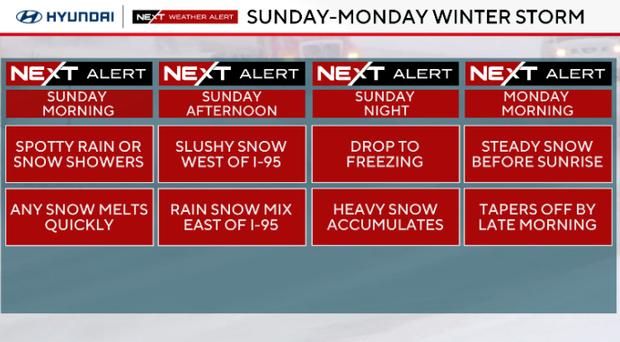
The heaviest snow is expected to fall between 6 p.m. and 6 a.m., then the storm will start to pull away between 10 a.m. and noon. By Monday night, snow showers and high winds will taper off. With high temperatures in the mid-30s, some melting could already begin Monday.
How much snow are we going to get?
The Lehigh Valley, Berks Chester and upper Montgomery counties are looking at about 6-10 inches of snow.
In Philadelphia, along the I-95 corridor, and in New Jersey and Delaware, at least 8-14 inches of snow could fall. Those totals are expected to be even higher closer to the coast, possibly up to 14-22 inches.
Storm timing
Sunday overnight: High winds and heavy snow falling up to 2 inches per hour, thundersnow and whiteout conditions are possible. Temps around 32 degrees.
Monday morning: Windy with heavy snow early then slowly tapering off between 6 a.m. and 10 a.m.
Monday Afternoon: Scattered snow showers and windy. Mid 30s.
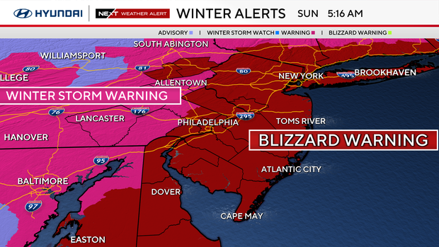
What weather alerts are in effect for the snow storm?
- Blizzard warning: In effect through Monday at 6 p.m. Includes all of New Jersey, Delaware and southeastern Pennsylvania, including Philadelphia. Also includes the Poconos. Impacts include whiteout conditions, dangerous and impassable roads, downed trees, widespread power outages, high surf and coastal erosion and school closings.
- Winter storm warning: In effect through Monday at 6 p.m. Includes Berks, Chester and upper Montgomery counties and the Lehigh Valley. Impacts include dangerous roads, low visibility, downed trees and power lines, power outages and travel cancellations.
- Coastal flood warning: In effect until 5 a.m. Monday. Includes all shore points, back bays and Delaware beaches. Impacts include strong winds that will push water into the area during high tides. Two-three feet of major flooding possible.
What should I do to prepare for the storm?
SNOW: Get snow blower, shovel, and ice melt ready.
CARS: Fuel cars, check tires, make travel kit for car.
PERSONAL: Charge all devices, preps for pets, prep for school closings and virtual learning.
TRAVEL: Be where you are going to be by Sunday evening, avoid driving unless necessary, reschedule airline flights if needed.
Here's your 7-day forecast:
Sunday/NEXT Weather alert: Winter storm. High 39, low 35.
Monday/NEXT Weather alert : Snow clears. High 38, low 31.
Tuesday: Mostly sunny, cold. High 33, low 25.
Wednesday: Quick snow, rain shower. High 43, low 25.
Thursday: Chance rain. High 46, low 34.
Friday: Few showers. High 43, low 31.
Saturday: Sun returns. High 52, low 27.


