Tornado confirmed in New Jersey as more rainfall expected in Philadelphia region tonight
After a day filled with heavy rains, flooded roads and whipping winds, the National Weather Service confirmed a tornado touched down in Collings Lakes, New Jersey, on Friday afternoon. According to the National Weather Service, the EF-0 tornado touched down at 12:52 p.m., had estimated peak winds of 65-75 mph and its path was measured at .5 mile.
No injuries were reported, according to the National Weather Service's storm survey. CBS News Philadelphia was on the scene in Atlantic County Friday afternoon as neighbors picked up the pieces after the storm had moved through. By 1:30 p.m. Friday, all tornado warnings issued in South Jersey had expired or been canceled.

It appears the storms have moved out of the Philadelphia region, but lingering showers are still expected. The NEXT Weather team is no longer tracking any severe weather warnings or watches, meaning the severe threat for Friday night has essentially diminished.
A severe thunderstorm watch previously issued by the National Weather Service for several New Jersey, Delaware and Pennsylvania counties, including Philadelphia, originally effective until midnight, was cancelled.
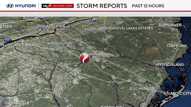
Earlier this afternoon, the National Weather Service said a severe thunderstorm capable of producing a tornado was spotted near Bridgeton around 12:42 p.m. and moving southeast at 30 mph. Radar indicated rotation in the storm, the NWS said.
We are still dealing with a few flood warnings around the region as lingering rain runs off to streams and creeks. Some roads were flooded due to Friday's heavy rain as well, leading to multiple water rescues. The National Weather Service has said Friday's earlier storms were observed with wind gusts up to 60 mph and hail the size of a quarter.
Here are the warnings currently in effect in the Philadelphia region.
Flood Warning
- Pennsylvania: Flood Warning is in effect for Bucks County until 12:45 a.m. Saturday and Philadelphia County until 1:30 a.m. Saturday.
Philadelphia weather forecast for the rest of the week
Saturday will be warm with highs in the mid-80s and some sun before the frontal passage, so we'll have to watch for potential strong or severe storms later in the afternoon or evening.
Sunday into next week looks more seasonable and sunny. Make those outdoor plans now for Sunday afternoon and soak in the sunshine, mild temps and dry air!
Here's your 7-day forecast:
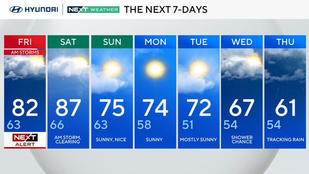
Friday: NEXT Weather Alert for morning storms. High of 82, low of 63.
Saturday: A.m. storm clearing. High of 87, low of 66.
Sunday: Sunny, nice. High of 75, low of 63.
Monday: Sunny. High of 74, low of 58.
Tuesday: Mostly sunny. High of 72, low of 51.
Wednesday: Shower chance. High of 67, low of 54.
Thursday: Tracking rain. High of 61, low of 54.
Get the latest weather info on the CBS News Philadelphia app