A pleasant Friday in Philadelphia, tracking when Hurricane Isaias could impact region. Here's the forecast.

Friday will pick up right where Thursday left off in the Philadelphia region, with cool and pleasant conditions in the morning before temperatures make their way back into the low-to-mid 70s Friday afternoon.
Fanning-out upper-level clouds associated with Hurricane Isaias will begin to arrive through the day Friday, but rain will remain well off to the south. Aside from the extra cloud cover through the second half of the day, Friday will be another great day.
NEXT big weather changes
The NEXT big change comes from Hurricane Isaias, which strengthened into a Category 2 hurricane Thursday.
Isaias will continue to strengthen as it tracks north Friday through the central Gulf. It will make landfall along the Gulf Coast late Friday into early Saturday near the Alabama or western Florida Panhandle coastline.
That's obviously a serious situation for the Gulf Coast, but the concern here in Philadelphia is what happens to the storm's moisture after landfall.
Saturday starts out nice as well, with some filtered sunshine and temperatures reaching the lower 70s before the clouds become overcast by the second half of the day.
Sunday is the day we're watching closely. After Isaias moves inland, it will weaken rapidly, but its moisture doesn't simply disappear. An approaching trough and frontal system will help pull that tropical moisture northeastward toward the Mid-Atlantic.
The result could be a period of widespread rain Sunday into early Monday.
Right now, the most likely timing for Philadelphia appears to be for rain to begin to arrive Sunday morning, with widespread, heavy rain through Sunday evening.
Rainfall totals of 1 to 2 inches are possible, with locally higher amounts depending on the eventual track of the remnants and where the heaviest rain bands set up. That could be enough to produce some localized flooding, particularly in poor drainage areas and locations that have been hit repeatedly by heavy rain over the past several weeks.
There is still uncertainty in the placement of the heaviest rain, so we'll be refining that forecast over the next couple of days.
For now, strongly favor Saturday for fall festivals, outdoor sports, pumpkin picking, or anything else you have planned this weekend. Sunday looks increasingly likely to be a wet day, particularly during the afternoon and evening.
At the Jersey Shore, expect deteriorating conditions Sunday as well, with rain and an increasing onshore breeze possible. The extent of any coastal impacts remains uncertain.
The remnants should move away Monday, with lingering showers gradually ending. Tuesday looks drier with temperatures in the mid-upper 70s, followed by another push of cooler air toward the middle of next week.
The bottom line: enjoy the pleasant weather Friday and Saturday. Sunday could bring our next significant rainfall event.
Here's your 7-day forecast:
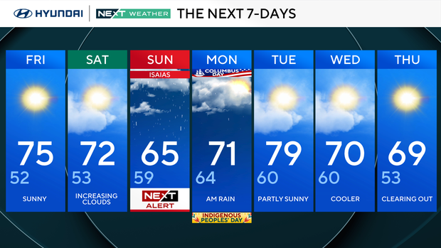
Friday: Sunny. High 75, Low 52
Saturday: Increasing clouds. High 72, Low 53
Sunday: NEXT Weather Alert. High 65, Low 59
Monday: AM rain. High 71, Low 64
Tuesday: Partly sunny. High 79, Low 60
Wednesday: Cooler. High 70, Low 60
Thursday: Clearing out. High 69, Low 53
Get the latest weather info on the CBS News Philadelphia app.


