Sunny, slightly cooler Friday in Philadelphia region. Here's the weather forecast.
The temperatures will remain well above normal, but we'll start the steps down from record territory on Friday in the Philadelphia region. It will still be shorts and T-shirt weather, and great weather to plan that evening grill cookout, though!
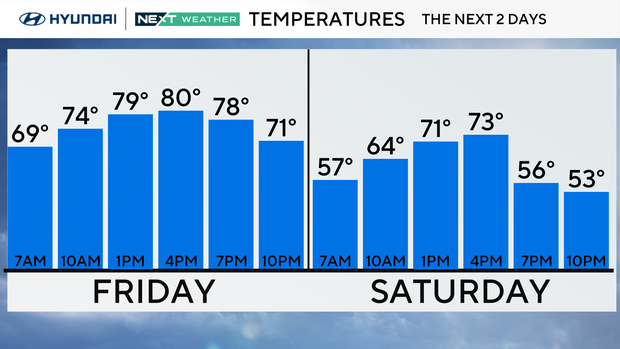
We'll warm back up with highs in the low 80s and a cooler breeze from the northwest. There could be a few spotty afternoon showers due to cooler air aloft.
Maybe even a good Friday night to set up the tent outside with the kids. Not too hot, not too cold and humidity levels are pretty low.
NEXT big weather changes
Temps will stay above normal Saturday with generally dry conditions. We'll start the day in the 50s and 60s and peak in the low 70s.
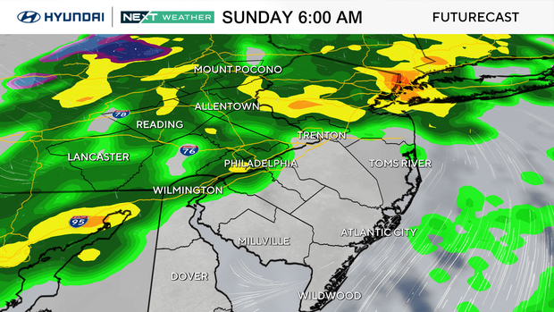
The NEXT significant weather change arrives Saturday night and brings showers, wind, and considerably cooler temps during the day on Sunday. At this point, severe weather chances are low, but like we do with all cold fronts we'll continue to monitor the situation.
Get ready for significant changes. As the band Europe told us, it's the "FINAL COUNTDOWN" as the cold air will take a big hold by early next week.
Monday's highs are only in the 50s, and frost or freeze advisories are possible by Tuesday morning with lows in the mid-30s, which is the average low in early December. Don't put the jackets too far away!
Here's the 7-day forecast:
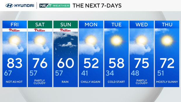
Friday: Not as hot. High 83, low 67.
Saturday: Partly cloudy. High 76, low 57.
Sunday: Rain. High 60, low 57.
Monday: Chilly again. High 52, low 41.
Tuesday: Cold start. High 58, low 34.
Wednesday: Partly cloudy. High 75, low 48.
Thursday: Mostly sunny. High 72, low 51.


