Mix of snow, rain will impact travel in Philadelphia region Tuesday. Here's the weather forecast.
After widespread precipitation moved into the Philadelphia region Tuesday morning, periods of heavy rain will continue in the city and all surrounding areas through around 4 p.m. Make sure you have the rain gear handy have those wipers on high.
While precipitation began as snow farther to the north and west of Philadelphia, anywhere south of the I-78 corridor saw a transition to mainly rain through mid-morning.
The city and points south to the Jersey Shore saw just a cold rain for the majority of the day.

There were scattered school closings and delayed openings around the Philadelphia area Tuesday.
Your commute could be impacted by wet roads that could slow you down. On top of that, PennDOT has reduced speeds on some highways in Pennsylvania, which could also impact your commute.
Speeds have been reduced to 45 mph on these highways due to weather:
- Interstates 78, 80, 81, 380,
- U.S. 22,
- Route 33.
The evening drive will dry out, but roads will still be wet and expect puddles and ponding to remain.
What's NEXT
Even the northern areas like the Lehigh Valley and Poconos, where there was snow earlier in the day, will likely see some rain or sleet mix in with the snow around midday.
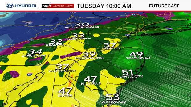
By the middle of the afternoon, the precipitation will start to clear out and likely be completely finished by 4 p.m.
The system will then pull away Tuesday night, with temperatures dropping back into the 20s, which will produce the concern for black ice for the morning commute Wednesday.
The remainder of the week remains well below normal with chilly temps. A push of even colder air Friday will hold temperatures below freezing for most of the day before another system brings the chance for winter weather Friday night into early Saturday morning.
The weekend stays chilly but generally quiet before another blast of cold arrives by the start of next week.
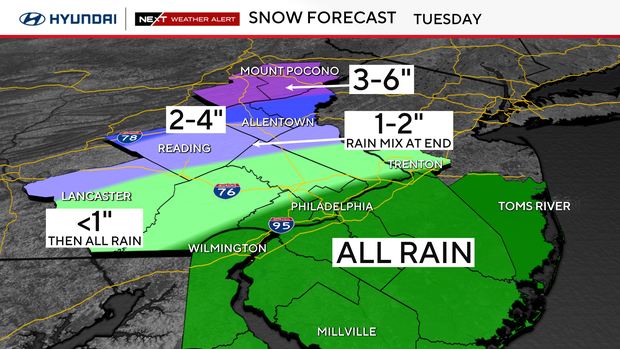
How much snow and rain will parts of Philadelphia region get Tuesday?
- New Jersey coastal plain and shore: All rain (1.00-1.25 inches) – Rain ends by 4 p.m.
- I-95 corridor & Pennsylvania suburbs: Few wet snowflakes at precip onset (4 to 6 a.m.), and maybe a quick coating in far northwest suburbs, but mostly rain. It will be three-quarters of an inch to an inch of good soaking rain. Rain ends by 4 p.m.
- Lehigh Valley: Starts as all snow before sunrise. Could see some light accumulation (1-2 inches) before rain and sleet mix in and snow begins to melt. Precipitation ends by 3-4 p.m.
- Poconos: Snow arrives a couple of hours before sunrise. Mainly showers continue most of the day (3-6 inches). Could see some sleet or rain mix in before precipitation ends. Precipitation ends through mid-afternoon.
Weather impacts at Philadelphia International Airport
The weather has impacted travel at Philadelphia International Airport, but as of around 12:30 p.m., there has only been one cancellation. According to FlightAware, there have been at least 136 delays at PHL.
Here's your 7-day forecast:
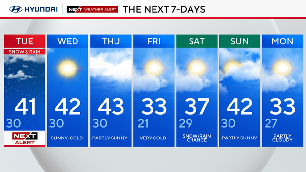
Tuesday: NEXT Weather Alert for snow and rain. High 41, Low 30.
Wednesday: Sunny, cold. High 42, Low 30.
Thursday: Partly sunny. High 43, Low 30.
Friday: Very cold. High 33, Low 21.
Saturday: Snow and rain chance. High 37, Low 29.
Sunday: Partly sunny. High 42, Low 30.
Monday: Partly cloudy. High 33. Low 27.