The NEXT Weather week ahead: Memorial Day edition
PHILADELPHIA (CBS) -- We're settling into the holiday weekend with a pretty big difference in temperatures across the area.
If you're in the mountains and Lehigh Valley, it's been a mostly sunny and warm holiday weekend so far. In the city, Saturday was sunny, Sunday brought us more clouds and even a sprinkle, and temperatures were on-point in the mid and upper 70s. Further south and east, shore points were cooler and cloudier, with scattered sprinkles and showers that extended down into Delmarva.
Monday brings us more of the same, with the coolest weather right along the Jersey Shore.
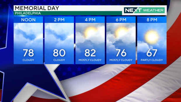
Memorial Day
With high pressure to the north along the Great Lakes, and a spinning system off the coast in the Carolinas slowly moving north, once again it'll be the southern areas (NJ and DE) that see the bulk of the clouds, cooler temperatures, and sprinkles/showers. Starting with Monday morning, fog will be a factor along the immediate shore, with an onshore flow. This light breeze off the water not only brings that reduced visibility in for the start of the holiday, but has also been responsible for producing the cooler weather all weekend long. (see below)

As a result of the system to our south, we'll see more of a mix of sun and clouds across the Philadelphia area and points north. While we can't rule out a scattered shower or sprinkle, most of the rain will stay to our south. Highs in Philly will reach the upper 70s and low 80s once again. The Jersey Shore will again be cooler, with highs in the upper 60s under a more overcast sky. A few scattered showers may not ruin all your outdoor plans all day long, but certainly keep an eye out for a few drops here and there.
Winds Monday night along the shore will increase as well, out of the NE at 15-25 mph, creating some rip currents. No doubt, swimming and boating will be impacted, so stay aware and please pay attention to the flags along the beaches.
Heart Of The Week
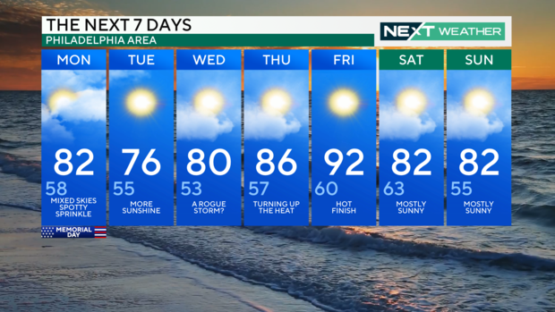
After Memorial Day, we'll see a stagnant forecast for the area, but the differences lay in where you are located. With high pressure to our north, and an upper and surface low to our south, expect mixed skies and rather dry conditions for Philadelphia and the Lehigh Valley. Further south, along the shore and into Delaware, scattered showers (although generally light) will continue through at least Wednesday. Morning fog may also be something to look for along the shore through at least the middle of the week.
In Philly, we may have a shot at a scattered shower or even a storm by Wednesday, as the area of low pressure reaches its furthest point north before heading out to sea. Severe weather is NOT likely. Highs will be close to average for the city in the low 70s, while shore points will be in the upper 60s to near 70 through Wednesday afternoon.
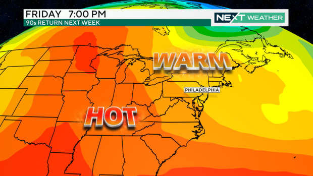
Late-Week Warm-Up
After we get the low out of the way, expect sunshine to return to the entire area (yes NJ, this means you too!). Also, expect to see a major increase in temperatures as well. An upper-level ridge will build by Thursday, pushing temperatures well into the 80s. By Friday afternoon, many spots including the city could easily reach the low to middle 90s, not too far off from record highs!
It will be a short-lived mini "heat wave", as the ridge breaks down by the end of the weekend along a cold front. While a scattered shower is possible in spots by the end of next weekend, most areas will remain dry.
Enjoy the holiday, stay safe, and remember to download the FREE CBS News Philadelphia Weather App so you can follow along with updates and check the live radar on the go!


