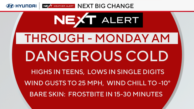
Brutal wind chills around Philadelphia Sunday, feels-like temperatures stay below zero most of the day
The last of the extreme cold continues Sunday and Monday.
Temperatures dropped to 8 degrees at Philadelphia International Airport this morning, the first single digit low for the city since 2022. Tonight's low will be 7 degrees, the 11th single digit low for Philly since 2015.
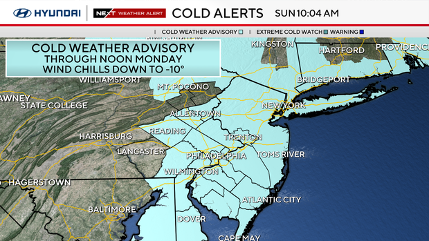
An extreme cold warning is in effect through noon on Monday in the Poconos, and a cold weather advisory remains in effect tomorrow for the rest of the region.
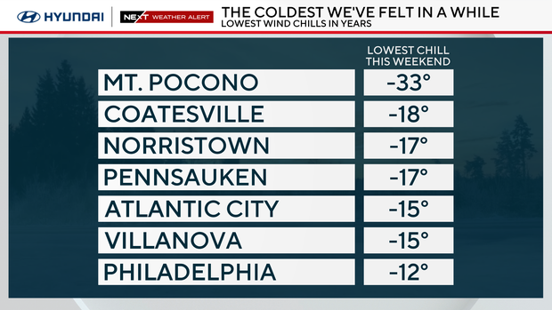
The wind chills this weekend dropped well below 0 in some places around the region.
NEXT weather change
Monday will be mostly sunny with another dangerously cold start in the single digits, but highs will be closer to 28 degrees.
Tuesday through Saturday, we'll warm to above freezing each day. Midweek temperatures could even reach 40 degrees. Overnight lows will be milder, too, with lows reaching the 30s some nights.
As a disturbance passes by to our north, there is a slight chance of sprinkles or a wintry mix Tuesday evening and Wednesday morning.
Looking ahead to Valentine's Day on Saturday, it'll be chilly but above freezing with highs in the mid to upper 30s with partly cloudy skies.
The models are conflicted about whether a large storm will bring rain and snow to the area next weekend. One says yes, and one says no. Keep checking on the NEXT Weather forecast – we should have a better idea midweek.
If you need help thinking warm thoughts, meteorological spring begins in just 23 days, and astronomical spring is 43 days away!
Here's your 7-day forecast:
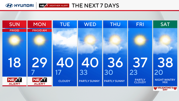
Sunday: NEXT Weather Alert. High 18.
Monday: NEXT Weather Alert. High 29, low 7.
Tuesday: Cloudy. High 40, low 17
Wednesday: Partly sunny. High 40, low 33.
Thursday: Partly sunny. High 36, low 30.
Friday: Partly cloudy. High 37, low 23.
Saturday: Night wintry mix. High 38, low 20.