Snow, ice to create dangerous travel conditions this weekend in Philly area. Here's the weather forecast.
After a nice Thursday in the Philadelphia area, things are going to take a turn. You may want to stay off the roads Friday evening and Saturday morning — be where you need to be by Friday afternoon!
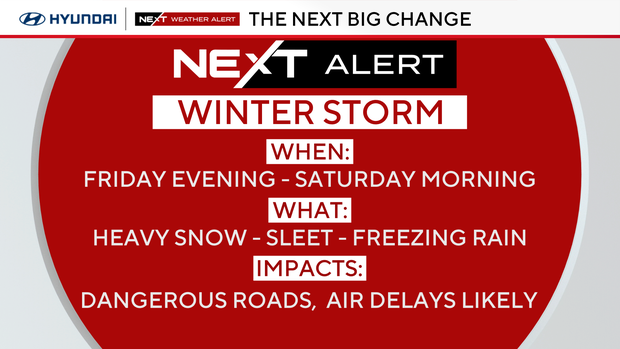
A NEXT Weather Alert is in effect from 3 p.m. Friday through 10 a.m. Saturday because of potentially dangerous weather. Other weather alerts including a winter weather advisory have been issued for Friday and Saturday.
NEXT big change: Dangerous winter storm
A strong winter storm system will pass just south of the area Friday evening and Saturday morning. This begins after 3 p.m. Friday and ends around 10 a.m. Saturday, and it will affect the entire region. Here's what to know:
- Depending on where you live, there could be heavy snow, a snow-freezing rain combo or mainly rain with some wet snow.
- The threat of freezing rain and ice is what makes this system so dangerous.
- Where that line of sleet and freezing rain sets up is the tricky part. A slight bump north or south could change the precipitation for better or worse.
- There will be periods of snow followed by sleet or freezing rain. Snow totals will include both the sleet and snow.
- The heaviest snow will be north of a line from the Lehigh Valley to Trenton, including North Jersey and New York.
- Philly, Southeast Pennsylvania and parts of South Jersey are on the edge of the snow/sleet line, with shoveling snow possible.
- Roads will be dangerous in places from either snowpack or 2 to 10 inches of ice.
Snow-sleet totals
- 5–8 inches (all snow): Lehigh Valley, Poconos, Upper Bucks, Trenton
- 3–5 inches (snow and sleet): I-95, Philly, Montgomery, Bucks, Camden, Burlington counties
- 1–3 inches (snow, sleet, freezing rain): Chester, Delaware, New Castle, Gloucester, Berks counties
- Coating–1 inch (mainly rain): Salem, Cumberland, Cape May, Atlantic, Kent counties
These will change depending on the amount of warm air aloft or if the track of the storm changes.
Winter weather advisory, winter storm warning in different parts of Philly region
The National Weather Service has issued a winter weather advisory for nearly our entire region, with the exception of Kent County, Cape May County and Atlantic County.
The advisory takes effect at 1 p.m. Friday for most of our area and lasts until 10 a.m. Saturday.
NWS says to beware of impacts including slippery, hazardous road conditions during the Friday evening commute.
A winter storm warning has also been issued for Monroe County, Pennsylvania.
What comes NEXT?
Another storm system on Sunday night will bring rain to the region, followed by another bitterly cold blast next week for the final week of 2025.
Here's your 7-day forecast:
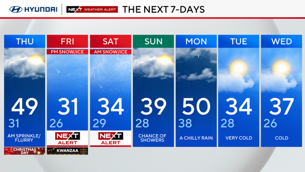
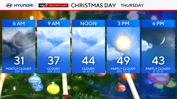
Thursday/Christmas Day: Morning sprinkle/flurry. High 49, low 31.
Friday/Kwanzaa: NEXT Weather Alert for afternoon/evening snow and ice. High 31, low 26.
Saturday: NEXT Weather Alert for morning snow and ice. High 34, low 29.
Sunday: Chance of showers. High 39, low 28.
Monday: A chilly rain. High 50, low 38.
Tuesday: Very cold. High 34, low 28.
Wednesday: Cold. High 37, low 26.