Freezing cold weather continues in Philadelphia area; bomb cyclone threatens coastal flooding, wind in N.J.
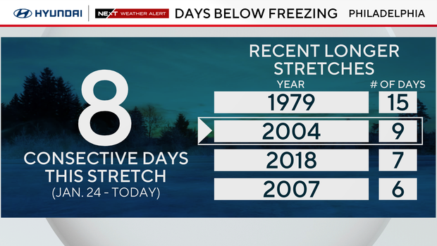
Philadelphia has not had a temperature above freezing since 7 p.m. on Saturday, Jan. 24, and our below-freezing stretch will continue through the weekend. Saturday is the 8th consecutive day with a high below 32 degrees; Sunday will be the 9th.
It will be the longest subfreezing stretch since 2004, when we had 9 days. Once we get to Monday (10 days), it will officially be the longest consecutive stretch since 1979 … nearly 50 years! Needless to say, temps this cold for this long don't happen too often here in the Philly area.
NEXT big weather change: Arctic air continues, monitoring the bomb cyclone and coastal impacts
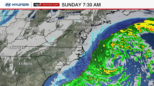
In addition, we are watching a strong coastal storm this weekend. The good news, as we continue to dig out from this past weekend's storm, is that the forecast model tracks continue to push the storm a bit farther east, taking the big snow potential with it.
The storm system will rapidly strengthen off the Carolina coast on Saturday, spreading cloud cover over our skies later this afternoon.
The center of the storm will track northeast, away from our coast, but a few fringe snow showers will still be possible right along the coast Sunday morning. This snow will produce little, if any, accumulation.
As the storm strengthens Saturday, it is expected to become what's known as a "bomb cyclone" — a term given to a non-tropical cyclone that undergoes a process known as bombogenesis, which is defined as a rapid decrease in pressure over a short period of time.
In our region, the generally accepted definition is a loss of 24 millibars of pressure over 24 hours. When a storm loses pressure, it's an indication of strengthening — so, at its core, bombogenesis means rapid intensification.
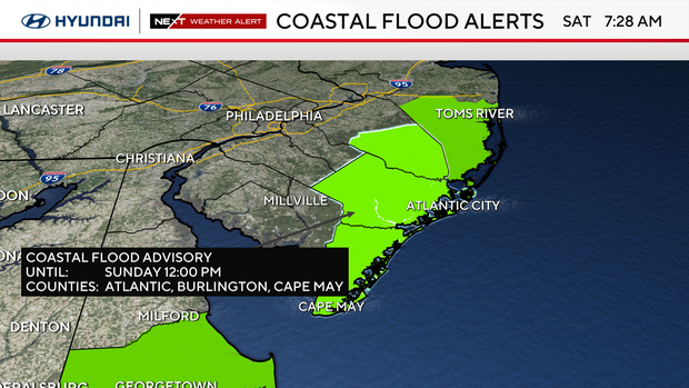
Because of the very strong low off the coast, we also must mention other impacts. We can expect wind gusts up to 50 mph along the New Jersey and Delaware coasts and the threat for coastal flooding thanks to the ocean water being pushed toward the coastline.
The greatest threat for some minor coastal flooding will be during Sunday morning's high tide which occurs at 6:46 am in Atlantic City. There is another high tide Sunday evening around 7:15 pm, but this high tide is not expected to produce as much of a flooding issue.
A coastal flood advisory has been issued for Atlantic, Burlington and Cape May counties. The alert lasts until 12 p.m. Sunday. A wind advisory is in effect in Cape May County, lasting until 4 p.m. Sunday.
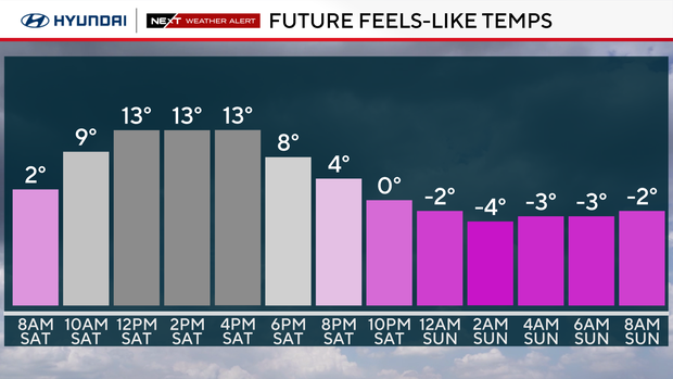
While the strongest gusts from the coastal storm will be along the coast, winds in Philadelphia could still gust to 30 mph Sunday, meaning the brutal wind chills will continue through the day.
This means temperatures will likely feel like the single digits despite actual temperatures in the middle 20s.
It'll remain breezy into Monday as temperatures try to climb into the low 30s.
Tuesday will be the best chance of warming above freezing for the first time in over a week. Don't get too excited though, because the high temperature will only be around 33 degrees.
By Tuesday, a fast-moving system will bring a small chance for a few snow showers, but at this time it only looks like light snow accumulations will be possible … if any at all.
Otherwise, the unseasonably cold weather looks to continue for the foreseeable future through next week and beyond.
Here's your 7-day forecast:
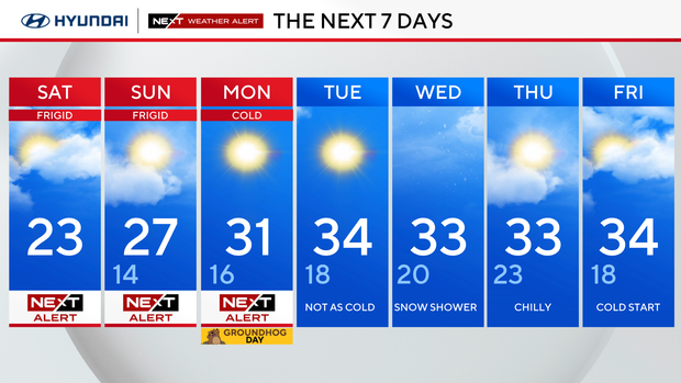
Saturday: NEXT Weather Alert for Arctic cold. High 25, Low 5
Sunday: NEXT Weather Alert cold and blustery. High 27, Low 14
Monday: NEXT Weather Alert freezing. High 31, Low 16
Tuesday: Not as cold. High 34, Low 18
Wednesday: Snow shower. High 33, Low 20
Thursday: Chilly. High 33, Low 23
Friday: Cold start. High 34, Low 18