NEXT Weather: Coastal flooding warnings, advisories end after remnants of Ian move through Philadelphia region
PHILADELPHIA (CBS) -- After leaving catastrophic damage in Florida and regaining hurricane status before hitting South Carolina, Ian's remnants impacted the Philadelphia region over the weekend with heavy rain and high winds.
Ian is no longer an organized storm, but we'll still see multiple issues from its remnants as we head into the beginning of the week.
There are several warnings and advisories in effect for the Philadelphia area, particularly in the Jersey Shore and southern Delaware.
Follow our live blog below for updates on how the storm is impacting the Delaware Valley.
Coastal flooding warnings, advisories end
Our NEXT Weather alert for the Philadelphia region will expire Tuesday night.
All coastal flooding warnings and advisories have ended.
On Wednesday, we will transition to drier weather as the remnant low moves further offshore by evening.
While minor coastal flooding is still possible at high tides Wednesday, it is below warning level and looks spotty.
Wednesday will still be cloudy as a few remaining bands of showers from Ian's remnants rotate through.
The best chance for rain is in the morning. Clouds will break by evening.
Thursday will sunny and pleasant with highs in the 70s.
Friday is warm once again but a cold front could trigger a few evening showers north and west.
The front clears the area Friday night, ushering in cooler temperatures for the weekend, but the sun sticks around.
Atlantic City bracing for more flooding as second round of storms moves through area
ATLANTIC CITY, N.J. (CBS) -- Cars were stranded and roads were shut down in Atlantic City after severe flooding this week. Now, the city is bracing for round two, which could be worse.
Eyewitness News was on Maine Street in the north end of the city and felt the wind and rain pick up throughout Tuesday afternoon.
The angry-looking ocean was caught crashing over the sea wall. It's an area that saw some heavy flooding on Monday, but the water receded overnight.
The city expects the area to flood again.
Atlantic City has also seen a significant amount of beach erosion here in the north end near the inlet.
The beach is practically gone, and the high tide line is up to the dunes.
The fire chief says dozens of cars were stranded and disabled yesterday in the floodwaters, now residents are being told to move their cars to higher ground.
"We are utilizing the sirens for this event warning people to move their vehicles off the flooded streets. So we do have sirens located in the various neighborhoods throughout the city. They are in the flood-prone areas so we're utilizing the sirens with different wailing noises or also putting out verbal messages," Chief Scott Evans said.
All city buildings closed at 2:30 this afternoon.
Everyone is being told not to drive through any water in the streets.
Flooding causes beach erosion in some Jersey Shore towns
WILDWOOD, N.J (CBS) -- Coastal towns in Cape May County continued to see flooding and beach erosion from the high tide Tuesday afternoon. North Wildwood's Mayor Patrick Rosenello said the ocean washed away about 30 feet of dunes on 15th Street.
Despite earlier concerns that water would breach the dunes during high tide, which would have caused damage to nearby businesses, Rosenello said the dunes remained in place.
A few blocks north of the dunes on 3rd Street, homeowners like Joe Surina took time from preparing their homes for flooding to watch the waves crash into the barrier wall.
"It's kind of sad to see the work that gets done every year rebuilding the beach, getting washed away with bad storms like this."
In Ocean City, homeowners Ed Kuehnle got groceries and prepared their homes for another round of flooding during high tide.
"We bring everything in from the outside," Kuehnle said. "We move our cars, if need be. This time we didn't need to."
The City of Cape May activated its flood sirens Tuesday afternoon after flooding along Yacht Avenue, and Venice and Bank Streets.
Rain, flooding concerns throughout region over next few days
PHILADELPHIA (CBS) -- Our Next Weather Alert Day continues through Tuesday afternoon, with waves of rain, gusty winds, and more flooding potential at the Jersey Shore.
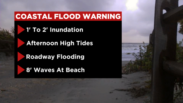
A Coastal Flood Warning and Advisory is in effect through 9 p.m. Tuesday to compensate for more issues along the coast with rushing water and high tides, and inland, along streams, rivers and inlets.
Waves as high as 8 feet will continue to pound the shoreline, along with 1-2 feet inundation. Areas from Atlantic County all the way through the Wildwoods and Cape May should stay clear of the coastline, and use caution when traveling along any roads close to the beaches and boardwalks. With high tides in the afternoons, even Wednesday may bring issues.
Further inland, bands of heavy rain will continue across the Philadelphia region. Areas that typically flood, like Kelly Drive, will have spots to avoid. Use caution and remember to "turn around, don't drown" when you're not sure how much water is standing in a roadway. Even just an inch or two of water can carry large cars away.
Thursday will be the day to relax, as the remnants of Ian finally leave us, giving the entire metro area sunshine and dry weather. Highs will be in the 70s by the end of the week.
Third day of remnants of Ian along the Jersey Shore
ATLANTIC CITY, N.J. (CBS) -- Tuesday, more rough weather conditions are expected down the shore as the remnants of Hurricane Ian continue to roll through our region. In Atlantic City, officials have activated its flood response plan and are urging residents to take proper precautions.
Atlantic City saw some soggy scenes Monday, from Atlantic City to Ocean City to Wildwood.
Police blocked off some of the worst roads but not before some cars were left abandoned in the middle of the road here in Atlantic City.
Tuesday is expected to be the third day of significant rainfall down the shore.
We have a full report on Atlantic City's flood response plan here.
Hurricane Ian's remnants cause coastal flooding at Jersey Shore
ATLANTIC CITY, N.J. (CBS) -- From Atlantic City to Ocean City and Wildwood, water flooded the streets and fierce winds caused the waves to crash on the boards. Hurricane Ian's remnants showed no mercy on the Jersey Shore, leading to coastal flooding.
Police blocked off flooded roads and cars were stranded in Atlantic City.
"We have a tremendous emergency management team," Atlantic City Mayor Marty Small said, "and we are preparing for everything."
PJ Buckets on Dorsett Avenue in Ventnor says the water normally doesn't come up this far, but the flooding didn't stop customers from coming on for Atlantic City Restaurant Week.
"It's a little flooded," a PJ Buckets employee said, "but we are still open as are the other businesses on Dorsett Avenue."
In North Wildwood, trucks tried to make it through the flooded streets.
Mayor Patrick Rosenello says he is worried about major beach erosion.
"To see the dune damage that we are getting today is a big concern for the rest of the winter," Rosenello said.
In Ocean City, schools closed early to beat the flooding.
At its worst, debris was seen floating down the street.
"A lot of stuff floating," Eileen Ball said. "We saw a lot. Pieces of deck and siding and a jet ski floated by."
As more rain is expected to fall, safety is a top concern down the shore.
"We encourage residents to stay safe," Small said. "Safety is paramount and that's why it is important that we take this storm seriously."
Atlantic City officials are urging residents to move their cars to higher ground and not drive through the floodwaters.
They are expecting even more flooding Tuesday.
Ocean City schools dismiss early as remnants of Hurricane Ian batter Jersey Shore
OCEAN CITY, N.J. (CBS) – Ocean City schools are dismissing early as the Jersey Shore continues to experience the remnants of Ian.
The Jersey Shore remains under a coastal flood advisory. The water level in the bay has receded but is expected to rise again Monday afternoon with high tide.
Read the full story here.
Strong winds from remnants of Ian take down large tree in Cherry Hill
Remnants of Hurricane Ian flooding parts of Ocean City, increasing travel time
OCEAN CITY, N.J. (CBS) – Remnants of Hurricane Ian are drenching the Delaware Valley and the Jersey Shore. The shore is under a coastal flood warning until Tuesday night.
Boat docks in the bay of Ocean City were almost completely underwater and flooding conditions closed some roads.
Read the entire story with statements from some locals here.
Red Cross volunteers from Philadelphia region in Florida helping with relief efforts
PHILADELPHIA (CBS) -- Florida is picking up the pieces of Hurricane Ian's deadly destruction. It could be months before debris is cleared and power is fully restored.
Red Cross volunteers from the Philadelphia area headed south late last week. And this weekend their relief efforts began.
Nineteen volunteers from Southeastern Pennsylvania and 30 from New Jersey are spread out across Florida with the destruction from Ian potentially not yet over.
Click here to read the full story.
Ian's remains threaten region with high winds, flooding, dangerous rip tides
PHILADELPHIA (CBS) -- Hurricane Ian is no longer an organized storm, but the Philly region will still see multiple issues arise from its remains as we head into the beginning of the week ahead.
High Wind Warnings and advisories are in effect for Burlington, Atlantic, Cape May and Cumberland Counties in South Jersey and both Kent and Sussex counties in Delaware. Wind gusts could approach or exceed 60 mph through early Monday morning, and perhaps last into Tuesday morning well. Downed powerlines with brief power outages are possible. Due to the saturated soil, there is a threat of downed trees. There will be travel impacts with slow commutes and airline delays. Winds in Philadelphia will gust between 30-40mph.
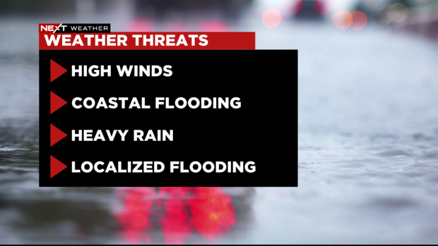
High tides will be an issue through the middle of the week, with afternoon tides from Atlantic City to Wildwood and Cape May running about 4 feet above sea level.
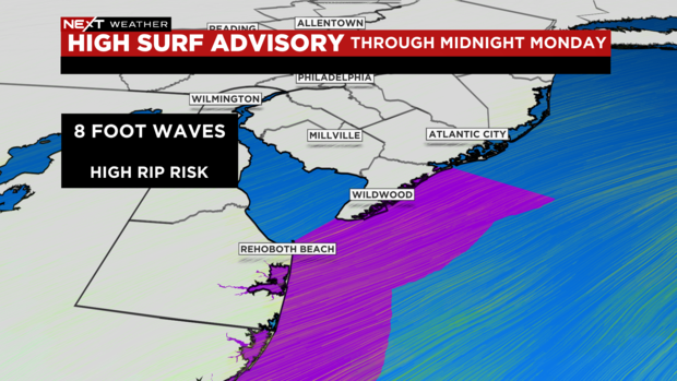
Away from the coast, a High Surf Advisory is in effect through Tuesday, with waves as high as 8 feet. It's advisable to stay away from the beaches and water -- at least through the middle of the week.
Heavy rainfall is cause for more flooding concerns across all of the Delaware Valley, with an additional 1-3 inches possible before all is said and done on Wednesday morning.
Localized flooding is not only possible along the shore, but also in the city of Philadelphia itself. In these times, we like to say "turn around, don't drown"-- if you see a flooded roadway, do NOT attempt to drive through it. Water rescues are common in these situations.
Temperatures will remain chilly, with highs in the 50s through Tuesday.
The good news? Sunshine and 70s return by the end of the week.
CBS3's Andrew Kozak reported on this post.
NEXT Weather: Remnants of Hurricane Ian deliver high winds, heavy rain and coastal flooding to the area
PHILADELPHIA (CBS) -- As the remnant, low-pressure center of what was Hurricane Ian approaches from the west, strong northeast winds will develop. Despite the fact that Ian is no longer a tropical cyclone, we will experience tropical storm force winds, waves of up to 8 feet on the shore, steady rain and coastal flooding.
High wind warnings and advisories are in effect for Burlington, Atlantic, Cape May and Cumberland Counties in South Jersey and both Kent and Sussex counties in Delaware. Wind gusts could approach or exceed 50-60 mph through early Monday morning. Downed power lines with brief power outages are possible. Due to the saturated soil, there is a threat of downed trees. There will be travel impacts with slow commutes and airline delays. Winds in Philadelphia will gust between 30-40mph.
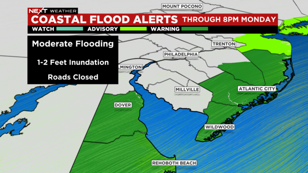
Those strong northeast winds will drive water onshore and there is a Coastal Flood Warning with a moderate coastal flooding threat for all beaches, back bays and tidal basins in South Jersey and Delaware. 1-2 feet of flood water is expected to cover roads and low areas. Numerous roads will be impassible, and any cars not moved may flood. Do not attempt to drive through flood waters. It poses a risk to your safety and damage to your car. Remember "Turn Around Don't Drown." The time of concern for coastal flooding is the afternoon. High tides are running about 4 feet above sea level. The highest tide times are in early and mid-afternoon Monday-Wednesday.
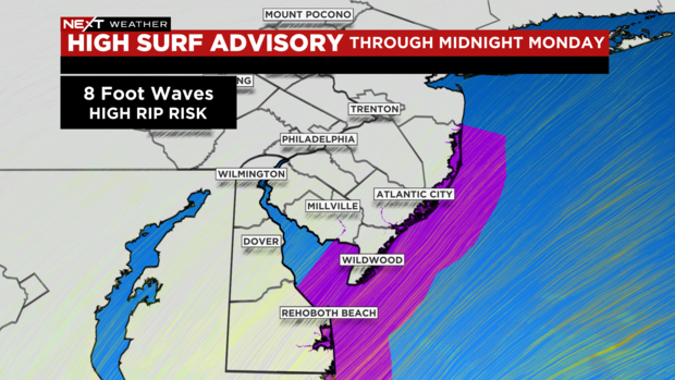
Turning to the ocean itself, a High Surf Advisory is in place through Monday with up to 8-foot waves on the beaches along coastal Atlantic and Cape May Counties in New Jersey, and Sussex County in Delaware. There is a Gale Warning for the open seas and a Small Craft Advisory closer to shore.
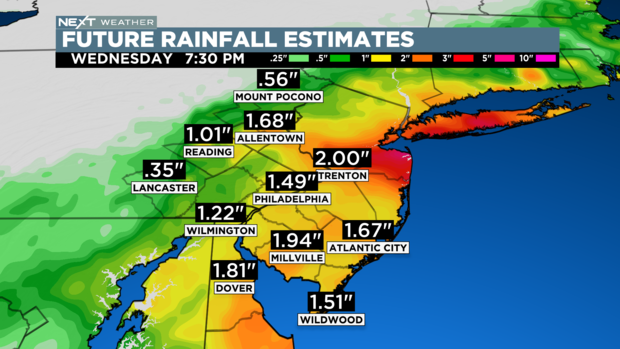
Steady heavy rain will fall across the entire area through Tuesday with totals exceeding 4" in some spots. The highest totals will be from the I-95 corridor south and east including Philly and the lowest totals will be north and west where totals of 2" are possible. Periodic flood advisories may be needed and if rainfall exceeds flood guidance, there may be brief flash flood warnings.

Finally, the temperatures will be chilly in the mid-50s through Tuesday. That is 10-15 degrees below normal for early October.
By Wednesday the coastal storm will head off northeast and we will begin to dry out.
NEXT Weather alert day issued for Sunday
PHILADELPHIA (CBS) -- Ian's remnants continue to be a problem for the Delaware Valley this weekend with rounds of heavy rain, gusty winds and the potential for hazards along the shore points.
Coastal Flood Advisories, High Rip Currents and High Surf Advisories are in place through at least Monday for much of the central and southern New Jersey coastlines. Large, breaking waves of up to 8 feet are likely, along with dangerous rip currents as well.
The Jersey Shore will also experience wind gusts of up to 50 mph throughout the day Sunday into early Monday. Along with the heavy rain, there could be some sporadic power outages to watch out for.
For Philadelphia, the rain Sunday could be heavy at times, with gusty winds upwards of 35 mph likely into the afternoon and early evening.
The good news? By Monday, the rain will lighten up, showers will (slowly) start to move out, and we'll see the winds decrease. Expect sunshine and 70s to return by the middle to end of the upcoming week ahead.
CBS3's Andrew Kozak reported on this post.
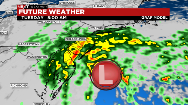
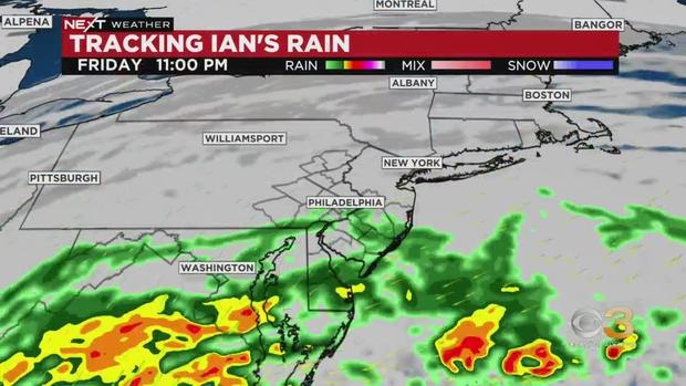
Tracking rain from Ian's remnants
Ocean City half marathon and 5K still on for Sunday
OCEAN CITY, N.J. (CBS) -- Some people down the Jersey Shore had to make adjustments to their plans due to the remnants of Hurricane Ian bringing rainy weather. There's some minor flooding in Ocean City.
Drivers are going through large puddles slowly to stay safe.
But regardless of the wet weather, the Ocean City half marathon and 5K is still happening Sunday morning.
Click here to read the full story.
Coastal Flood Advisory in effect
PHILADELPHIA (CBS) -- A Coastal Flood Advisory is in effect in New Jersey and Delaware until 6 a.m. on Monday.
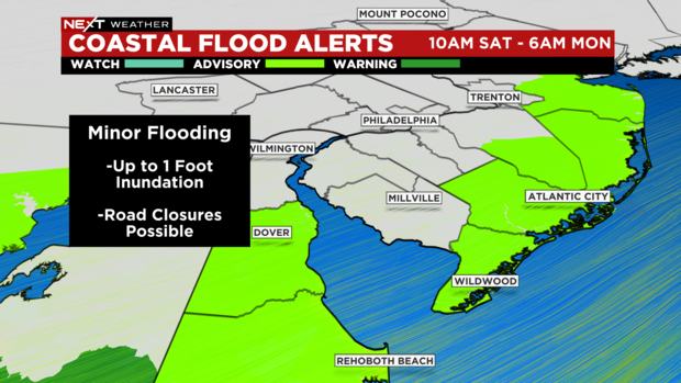
There's up to 1 inch of inundation in back bays and basins with low lying areas and some roads are covered.
Several South Jersey police departments announce wind advisory
PHILADELPHIA (CBS) - South Jersey is expected to see some high winds over the weekend. A few police departments have tweeted out wind advisories.
Middle Township Police tweeted, "Wind Advisory until 04:00 a.m. Monday."
Maple Shade Police tweeted the same advisory.
Galloway Township Police tweeted about the same wind advisory going into effect Saturday at 3 p.m.
NEXT Weather forecast is tracking Hurricane Ian
Rain on and off as Philadelphia feels remnants of Hurricane Ian
PHILADELPHIA (CBS) – The remnants of Hurricane Ian are bringing heavy rains to the Philadelphia area, and those downpours are expected to carry throughout the weekend.
Saturday morning it's been raining on and off. When it does rain it hits hard, it's cold and windy - sounds like fall. However, we can consider ourselves fortunate in comparison to southern states.
Video from Friday shows Hurricane Ian making its second landfall as a category one in South Carolina, bringing lots of flooding.
As this storm was downgraded to a tropical storm, lots of rain and many people were without power.
CBS3 is continuing to watch what's happening in Florida as the death toll is at 23 people now.
Back in Philadelphia, lots of rain and wind. If you are heading out Saturday, you are going to want to put on the rain gear and extra layers.
NEXT Weather alert for Saturday, Sunday as Hurricane Ian's remnants move through
Hurricane Ian made its third and final landfall in South Carolina Friday afternoon before becoming a post-tropical cyclone. However, Ian's rain will still impact us and it will do so in two waves: a coastal low that swings through tonight, and a second area of low pressure containing the remnant circulation of Ian, which moves through our region Sunday before swinging off the coast.
The first wave is tonight through the early morning hours Saturday. Heavy tropical downpours will lift through all night from south to north, delivering a general 1 to 2 inches of rain by early morning, with locally higher amounts possible near the coast. Winds will pick up as well, gusting over 30 mph at the shore and over 25 mph inland.
Once the rain moves out in the early morning, the majority of Saturday appears to be dry as a dry slot will set up between the two pieces of Ian. It's still chilly and cloudy and very windy, but if you want to get outside without an umbrella, late Saturday looks like the best shot.
The second wave of low pressure will impact us Sunday, and even though the rain doesn't look quite as intense, it'll be more prolonged. Rain will fill in throughout the day and just get heavier as the afternoon progresses.
One thing to watch will be the potential for bands of heavy rain to set up Sunday night across South Jersey and Delaware as the low moves off the coast.
Some spots, mainly southeast of Philadelphia, could end up with a total of over 4 inches of rain before the storm is finished with us.
While the antecedent dry conditions mean the threat for flooding is relatively low and the rain is largely beneficial, if it falls too heavily for too long we could be looking at the potential for localized or flash flooding.
Coastal impacts will also increase throughout the weekend as the storm begins to shift offshore. Minor coastal flooding is possible through the weekend, and depending on the location of the low next week, could increase to moderate coastal flooding Monday -- wouldn't be surprised to see a Coastal Flood Warning issued in spots. A High Surf Advisory and High Rip Current Risk are also in the forecast this weekend -- definitely not a good weekend to be in the ocean.
Ian's remnants will finally relax their grip on our region by the middle of next week.
Hurricane Ian makes second landfall in South Carolina
Rain starting to move into southern Delaware
The rain from Ian is starting to stream north, and parts of Sussex County in Delaware are starting to get hit with rain.
The heaviest rain won't move into the Philly region until Friday evening.
Those downpours will continue overnight into Saturday morning.
Parts of Delaware could see rain Friday afternoon
The rain from Ian isn't supposed to hit most of the Philadelphia region until Friday evening, but parts of southern Delaware including Sussex County, could get hit in the afternoon.
If it does, it will be a light rain.
The heavier rain isn't expected to move into the region until overnight from Friday into Saturday.


