Hurricane Lee expected to intensify, but will it hit the East Coast?
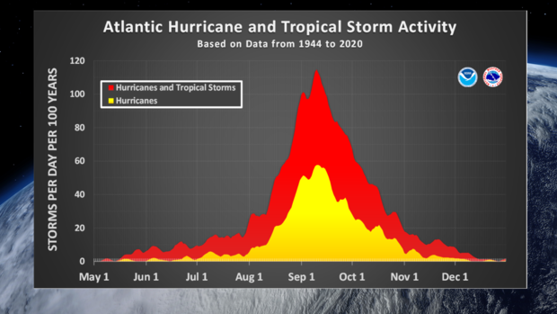
NEW YORK -- September 10th marks the statistical peak date of hurricane season, and we are right on par with it, as Hurricane Lee and Tropical Storm Margot swirl simultaneously in the Atlantic.
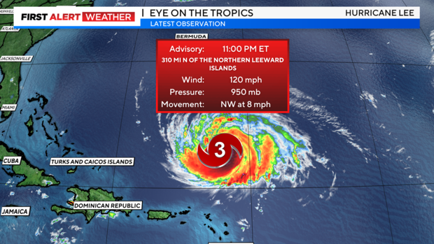
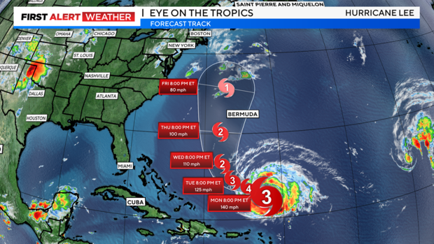
After substantially weakening on Saturday, Lee is showing signs of intensifying once again. The storm's eye has redeveloped, and is well defined, while his structure is looking more symmetrical. These are indications that Lee is determined to become at least a Category 4 storm. And that is in fact what the latest forecast from the National Hurricane Center calls for. Lee will most definitely gather fuel from the very warm waters that currently lie ahead.

The forecast models have speeded Lee's movement up so that by Friday he's nestled between Bermuda and North Carolina. But will Lee hit the East Coast?
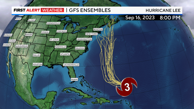
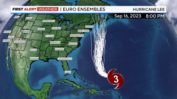
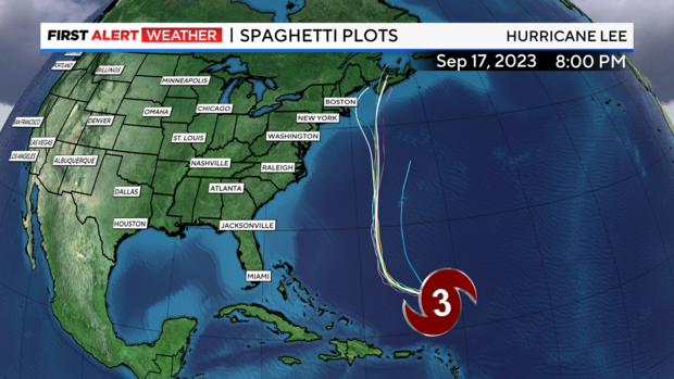
While the verdict is still out on that, some recent model projections are more concerning. For the past week, the models have been back and forth with where Lee ultimately winds up. The final solutions of the two most prominent models, the GFS and European, both have consistently shown Lee not making a landfall in the U.S. but heading to the Canadian Maritimes instead.
However, the latest run of the GFS wants to bring Lee straight into New England, while the European has him making a visit to Nova Scotia.
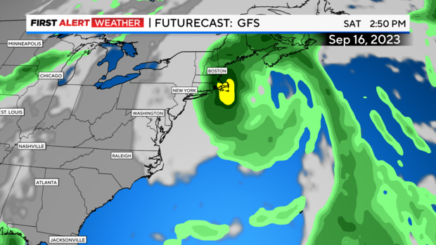
Some of the ensembles, which essentially are blends of many different models, also suggest that Lee will be making a landfall along the East Coast, with Long Island being one of the possible locations of landfall.
Yes, those are outliers, but definitely cannot be discounted just yet.
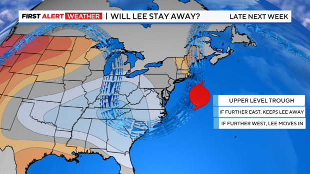
Multiple factors will have a hand in deciding Lee's final destination. The presence of an upper-level trough that is forecast to be situated along the East Coast late in the week is the greatest factor.
If the trough sets up further east, Lee will be steered further north into Canada. If the trough sets up further west, Lee may get drawn straight into the Northeast coastline, such as was the case with Superstorm Sandy.
The latter scenario is not very typical but looks more probable than it did a few days ago. Another factor, Lee's speed, will determine which direction the trough will be able to direct Lee to.
As Lee travels northward, he'll encounter cooler waters, thus weakening him again. Some of that coolness is actually linked to Tropical Storm Idalia and Hurricane Franklin. Both storms lingered in the Atlantic for several days, two weeks ago, and were able to draw up colder water from the deeper levels of the ocean, a process called upwelling.

This will work in our favor so that even if Lee comes to our region, we'll be dealing with a Category 1 storm, and not a Category 3 or higher. One other result of Lee's northward progression will be that he'll grow in size. This means that even if the storm does not make a direct impact to our area, the wind field will be so large that we'll see at least some wind from it, even if the center of circulation is several hundred miles away.
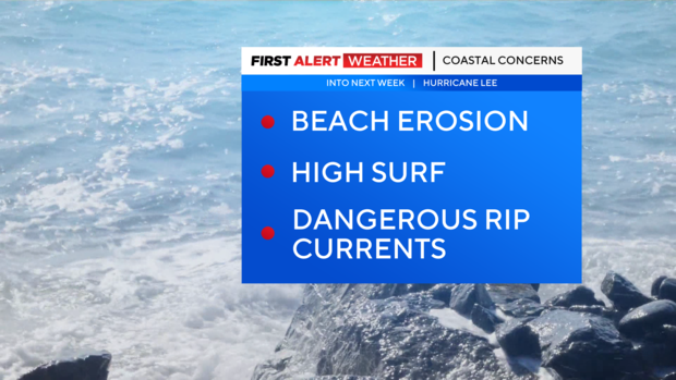
We still have time to watch Lee, and it is very likely the models will shift again. In the very least, high surf, dangerous rip currents, and beach erosion will be observed at our local beaches throughout the upcoming week. The average margin of error increases the further in time the forecast is from the actual event. Meaning that by days 4 and 5, Lee could be between 145-200 miles from where the models are projecting him to be now.
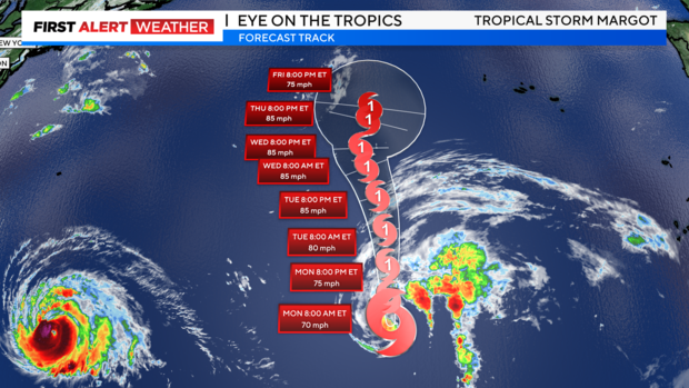
Meanwhile, Tropical Storm Margot is expected to strengthen into a hurricane as well this week. Thankfully, Margot poses no threat to land as of now.
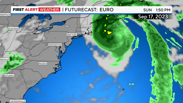
Hurricane Lee's potential impacts in NYC, New Jersey, and more
Jersey Shore:
Some breezy conditions, high surf, dangerous rip currents, and beach erosion. Waves 9-12 feet.
Long Island & Coastal Connecticut:
Moderate to heavy rain, especially east. Gusty winds, with at least 40 mph gusts. High surf, dangerous rip currents, and beach erosion. Waves 9-12 feet.
NYC:
Maybe a few showers, otherwise mostly cloudy and breezy. City beaches will see high surf, dangerous rip currents, and beach erosion. Waves 9-12 feet.
Hudson Valley, Northern & Central New Jersey, Inland Connecticut:
Not much effects in these areas other than some clouds and breezy conditions at times.


