NYC snow forecast: Updated snowfall accumulation map around Tri-State Area
NEW YORK -- A winter storm moved in late Monday night, blanketing New York City and Tri-State Area with snow.
The snow continues to fall Tuesday, with some mixing along the coast by midday. The precipitation is expected to taper off later in the afternoon.
Once it's all said and done, the city and coast will likely see 1 to 3 inches of accumulation, with 2 to 5 inland and northwest.
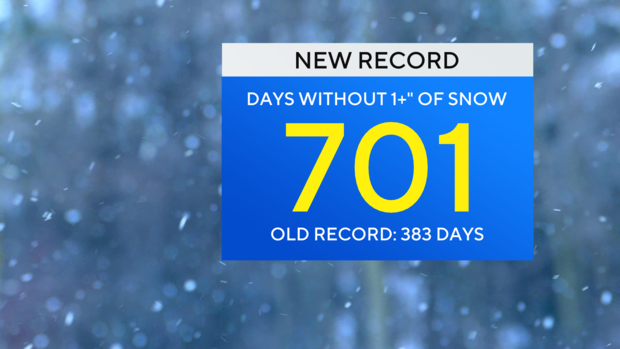
As of 7 a.m., Central Park recorded at least 1 inch of snow for the first time in more than 700 days, ending the streak and setting a new record.
Temperatures will also be very cold Tuesday, with highs right around the freezing mark.
Red Alert remains
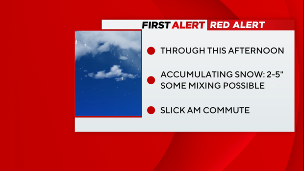
We're on Red Alert for a messy a.m. commute and light-to-moderate snow accumulations.
A Winter Weather Advisory is still in effect for the entire area through the afternoon, due to additional light snow accumulations, mixed precipitation and hazardous road conditions.
Timing and Totals
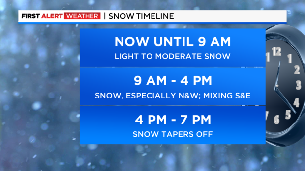
Rest Of Tuesday: Snow continues through the late afternoon hours. It will be light to moderate at times. A changeover to rain is likely for the Jersey Shore and Long Island after 10 a.m. as warmer oceanic air gets drawn into the system. This will lower snow totals for those areas. The rain/snow line will reach the city, leading to a period of mixed precipitation by noon. The mixed precipitation will include sleet and a bit of freezing rain. Then as colder air filters back in, a changeover back to all snow will ensue for all areas after 2 p.m.
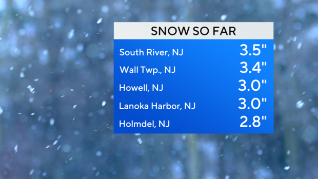
In general, most of the region will see final snow totals between 2-4 inches. A bullseye of higher totals, between 3-5 inches, is anticipated for northern New Jersey and the lower Hudson Valley. Many communities to the south and east of the city will see 1-3-inch totals. Highs will be in the low 30s. After the storm departs by the evening hours, temperatures will drop sharply into the teens and 20s, with gusty winds and low wind chills. A flash freeze is almost certain, leading to very icy roads and sidewalks.
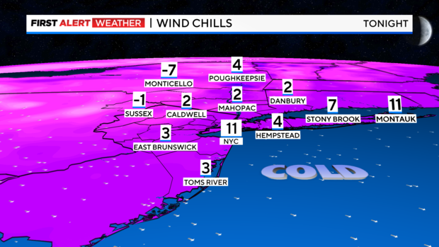
Overnight: Very cold. Wind chills falling into the teens and single digits with perhaps some sub-zero wind chills N&W. Watch for refreezing.
Wednesday: Mostly sunny, but very cold. Highs in the 20s with wind chills in the teens.
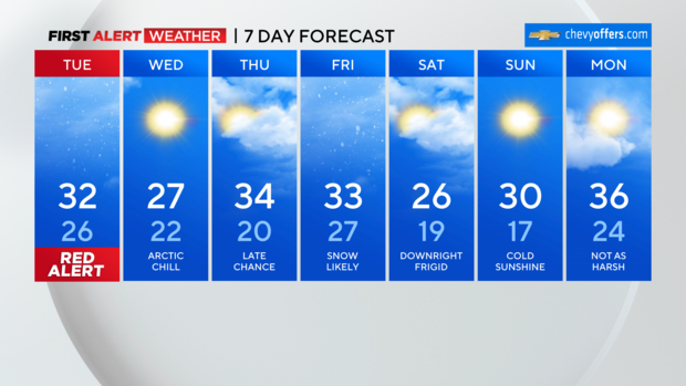
Thursday: Still cold with a late chance of snow. Highs in the low 30s with wind chills in the 20s.
Friday: A little snow likely. Highs in the 30s.
Rivers update
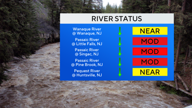
Major flooding has subsided, but moderate flooding is still ongoing across the Passaic River basin. After peaking Sunday morning, water levels will continue to slowly come down, however, the river will remain at flood stage through Wednesday. Other rivers in the region, such as the Wanaque, have already peaked and will continue to fall throughout the next few days. With very cold temperatures expected, it is very likely that much of the standing water linked to the flooding will freeze. This can create more of a hassle for residents trying to clean up after the floods.
Stick with our First Alert Weather team for the latest forecast, live radar and weather alerts.


