First Alert Weather: Red Alert for heavy rain, strong wind Tuesday into Wednesday
Alerts
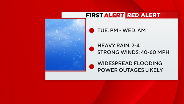
- Red Alert remains in place from through Wednesday morning
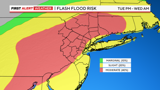
- Flood Watch is in effect from through Wednesday
- High Wind Watch for the Jersey shore, Staten Island, Brooklyn, Queens and Long Island through early Wednesday
Forecast

Monday looks to be bright and beautiful, with highs in the low 40s, before another, more potent storm wallops the region.
That storm, which is currently over the Southwest, is poised to whip its way into the region later on Tuesday. Our forecast models indicate that it will have lots of energy to work with and has the potential to cause major problems.
Snow will not be one of them this time.
Potential impacts
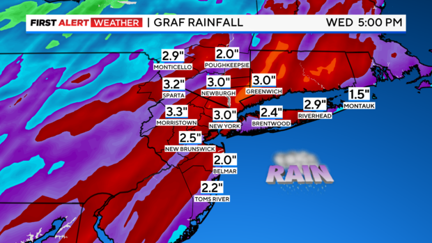
Heavy Rain: The storm will be able to tap into deep, tropical moisture all the way from the Caribbean Sea. Because of this, flooding rain is our greatest concern. Forecasted rainfall totals are between 2-4 inches. These numbers would be troubling at any time, however, with an already saturated ground from numerous recent storms, the flash flood risk is much greater. For areas that received snow this weekend, that heavy rain on top of the snowpack that will melt rapidly and could lead to moderate and major riverine flooding. Of particular concern are cities and towns in and around the Passaic and Raritan River basins.
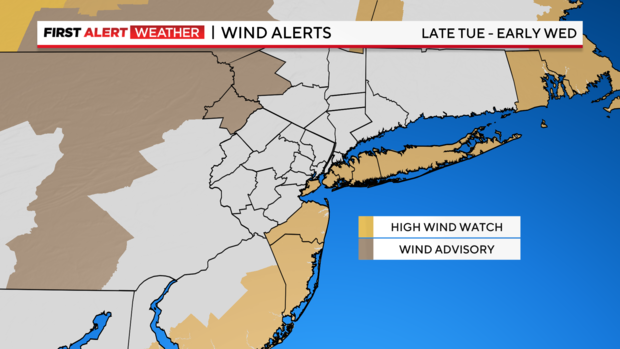
Damaging Winds: Given the strength of the storm, it will be capable of producing damaging winds between 40-60 mph. The saturated ground will make trees more susceptible to getting toppled over and powerlines may also get taken down with them, so therefore, power outages are highly likely.
Coastal Flooding: Also, as a result of the strength of this storm, those strong winds could send powerful waves onshore, and thus lead to moderate and severe coastal flooding, as well as beach erosion. We're talking 3-4 feet of inundation potentially. To make matters worse, the proximity to the New Moon on 1/11 will have tides running higher than normal.
Timing it out
12 - 5 p.m. Tuesday: The storm begins its arrival. Moderate rain bands start to engulf the region. Rain coverage and intensity gradually increase by late afternoon. Winds will also progressively get stronger, especially at the coast, gusting between 20-40 mph. Temperatures will stay in the 40s.
5 p.m. Tuesday - 4 a.m. Wednesday: This is when the storm is at its peak. Throughout this time frame, torrential rain and strong winds will unfold. A few embedded thunderstorms are even possible. Freshwater flooding is very likely, especially in New Jersey, but so too is coastal flooding and beach erosion, as onshore winds pile waves along the coast. This would be particularly bad during the morning high tide cycle. Those winds may gust between 40-50 mph at times. Higher gusts are possible at the immediate coast, particularly coastal areas of Long Island and New Jersey, where gusts may reach up to 60 mph. Temperatures rise into the mid 50s throughout the overnight hours. Rivers have already begun responding to the rain from Tuesday afternoon.
At least a half inch of rain had already fallen in various spots by 7 p.m., and there were gusts of 40 mph in Babylon.
Rest of Wednesday: Though the heaviest rain will already be over for most areas, some lingering showers are still possible. The gusty winds will continue through the day, gusting between 25-40 mph. Final rain totals will average between 2-4 inches, with higher totals in some locations. Residual coastal and flooding from the rain is very likely at this time. Rivers will also start to rise, with flooding becoming more prevalent later in the day and into Thursday. Highs will be reached early in the morning, with falling temps throughout the day.
Follow our First Alert Weather team for the latest track and timing as the storm develops.


