NEXT Weather: 2-wave storm system could produce historic snow totals
This is a previous weather story, click here for live updates from Tuesday.
MINNEAPOLIS – A two-punch storm system is headed towards Minnesota, with the possibility of more than 20 inches of snow stacking up in the Twin Cities by the end of the week.
Tuesday, Wednesday and Thursday will be NEXT Weather Alert days. It's advised to prepare with supplies and a winter kit for your vehicle if you need to go out on the roads.
RELATED: Twin Cities road crews finalizing plans for massive winter storm
The first wave of this long-duration storm system arrives after lunch time Tuesday, which is when a Winter Storm Warning will go into effect in the Twin Cities and a large swath of southern Minnesota. That warning is expected to last through Thursday evening. Temperatures will be noticeably cooler Tuesday, topping out at 21 degrees in the metro. Winds will also start to pick up from the northeast in the afternoon.
The evening commute will be a rough one. This first wave will exit the metro early Wednesday morning, leaving about 3-5 inches in its wake. More accumulation is expected in the south, with the southwest corner of the state seeing totals upwards of 8-9 inches.
RELATED: Delta, Southwest airlines issue waivers ahead of major winter storm
There will be a lull in the action until midday Wednesday, when the second wave arrives, and this one will be a doozy. Snow is expected to fall at a rate of 1-2 inches per hour from Wednesday evening through Thursday evening. Wind chills could dip as low as -5 degrees Thursday morning.
It will be tough to tell what snow is falling and what is blowing around due to wind speeds that could be as fast as 50 mph. Expect several counties, especially in western Minnesota, to be under Blizzard Warnings Wednesday and Thursday.
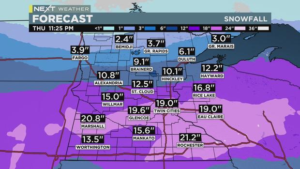
The snow total models at this point, even the conservative ones, are nothing short of eye-popping. By Thursday night, the metro could see 15-20 inches of accumulation – placing this storm on the top 10 list of the biggest on record in Minnesota.
Thursday's high will be 17, and Friday will be several degrees cooler, but free of precipitation. Highs will reach back into the mid-20s this weekend. That's below average, but it will be calming in comparison to our wild week.
Click here for a breakdown of snow emergencies around the metro this week.


