NEXT Weather: After warmest February day on record, cold and snow return Tuesday


MINNEAPOLIS — After the warmest February afternoon on record Monday, the forecast is heading in the opposite direction Tuesday.
Less than an inch of light snow is expected to fall in the Twin Cities Tuesday between 3 p.m. to 7 p.m., with minimal impacts on the evening commute. In northwestern Minnesota, however, travel is not advised on Highway 75 between Warren and Humboldt. Roads north of Detroit Lakes and west of Clearbrook are partially covered in snow, according to the Minnesota Department of Transportation.
MORE: Owatonna blizzard baby celebrates 1st birthday amid historic February warmth
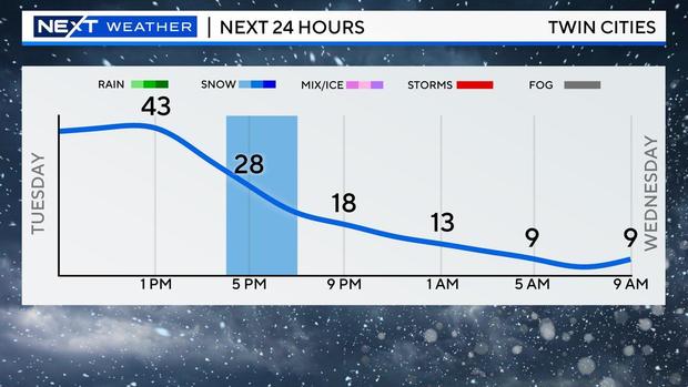
The forecast high is 43, but temperatures will fall through the rest of the day, with strong winds arriving by the early evening. It will be in the mid-20s but will feel like 10 degrees.
The greatest impact will be the freezing of any precipitation overnight for slick spots during the Wednesday morning commute, when temps will be in the single digits but feel like the minus-teens.
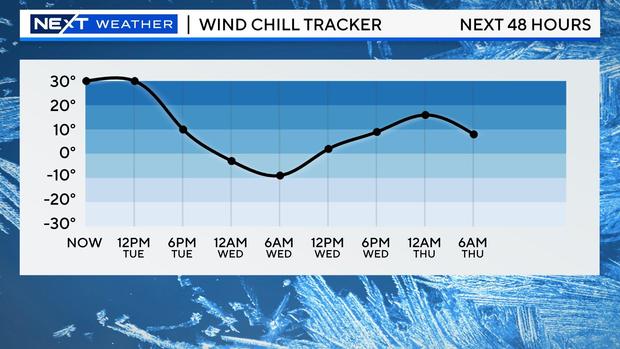
Wednesday will be breezy with highs only in the low 20s.
Thursday and Friday will be in the 50s, and temps will rise into the 60s this weekend.
The metro's next shot of rain will be on Monday.
MORE: "The Daily Show" features Duluth, Minnesota in cheeky video about climate refuge cities


