Heavy rain, king tides bring renewed flooding threat to South Florida as storms move in

South Florida is in for a wet Wednesday as showers and thunderstorms are expected to become more widespread later in the day, bringing the potential for heavy downpours and localized flooding.
The rain comes as higher-than-normal king tides continue to raise the risk of saltwater flooding along the coast. A coastal flood advisory remains in effect through Wednesday morning, followed by a coastal flood statement through the afternoon because of the potential for moderate coastal flooding.
Conditions were relatively quiet across Broward and Miami-Dade counties early Wednesday, but rain chances are expected to increase through the day. Spotty showers and storms could develop during the morning before more widespread storms arrive around midday and into the afternoon.
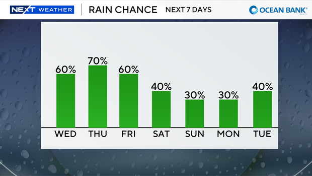
Some of the heaviest downpours could coincide with the afternoon and evening commutes, potentially causing flooding in areas that receive repeated rounds of rain.
King tides bring additional flooding concerns
High tide in Fort Lauderdale is expected around 12:21 p.m. Wednesday and again at 12:29 a.m. Thursday. In Miami, high tides are expected around 12:02 p.m. and 12:06 a.m.
In Key West, the next high tide is expected around 1:41 p.m., followed by another around 12:55 a.m.
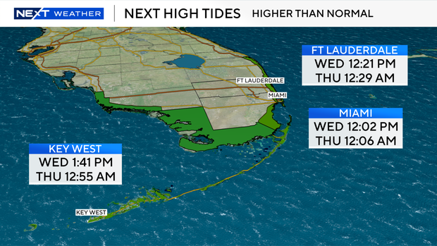
The combination of heavy rainfall and elevated tides could make it more difficult for water to drain in vulnerable coastal areas.
Temperatures Wednesday will climb into the mid- to upper 80s under mostly cloudy skies. There is a low risk of rip currents along South Florida's Atlantic beaches, and no advisories or alerts are in effect for boaters.
Wetter start to October expected Thursday
Rain chances will increase further Thursday as additional moisture moves into South Florida, setting up a soggy and breezy start to October.
Showers and thunderstorms are expected to become widespread earlier in the day Thursday and continue on and off, with heavy rainfall and localized flooding again possible.
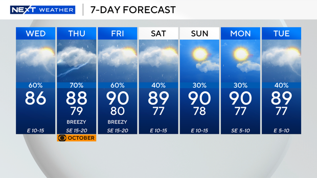
The wet pattern should begin to ease heading into the weekend. Scattered storms are expected Saturday, followed by more isolated storms Sunday.
More sunshine is also expected over the weekend, with afternoon highs climbing to around 90 degrees.