King tide flooding possible in South Florida as Hurricane Isaias makes landfall in Florida's Panhandle


South Florida can expect a dry Friday with plenty of sunshine, but it's going to feel steamy.
Drier air is starting to push into South Florida, so there will still be a chance of passing showers.
It's going to be a hot and humid afternoon in South Florida with a forecast high temperature of about 90 degrees.
King tide coastal saltwater flooding is also possible around high tide on Friday at approximately 10 p.m.
Rain will return overnight into Saturday morning with some scattered thunderstorms possible.
The breeze is also expected to build throughout the day, with a chance of passing showers and storms.
High temperatures are expected to rise into the low 90s.
The chance of rain is expected to be lower on Sunday, with only an isolated thunderstorm or two possible.
High temperatures will remain near 90 degrees.
Lower rain chances continue through the early and middle part of next week.
Hurricane Isaias makes landfall in Florida's Panhandle
Hurricane Isaias has weakened from a Category 3 back down to a Category 2 hurricane, with winds at 110 miles per hour as of Friday night.
Hurricane Isaias makes landfall near Destin, Florida, around 9:30 p.m. ET (8:30 p.m. CT) with maximum sustained winds of 105 mph.
A NOAA water level gauge in Panama City Beach measured a storm surge of 5.6 ft.
A wind gust of 116 mph was measured at a WeatherFlow station near Santa Rosa Sound.
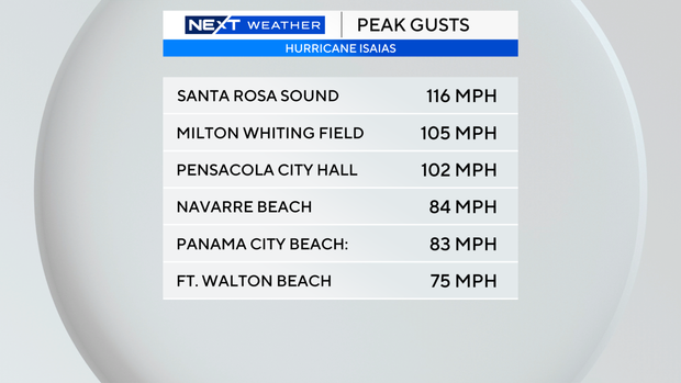
The storm's impact was already being felt along parts of the Gulf Coast, with dangerous surf and powerful winds hours before landfall.
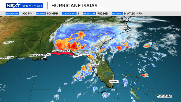
The hurricane warning west of the Mississippi-Alabama border, the tropical storm warning west of Ocean Springs, Mississippi, the storm surge warning west of Dauphin Island, Alabama, and the storm surge watch east of the Suwannee River, Florida, have been discontinued.
Meanwhile, a storm surge warning is in effect from Dauphin Island, Alabama, to the Suwannee River, a hurricane warning is in effect from the Mississippi-Alabama border to the Bay-Gulf County line in Florida, and a tropical storm warning is in effect from east of the Bay-Gulf County line to the Aucilla River, Florida.
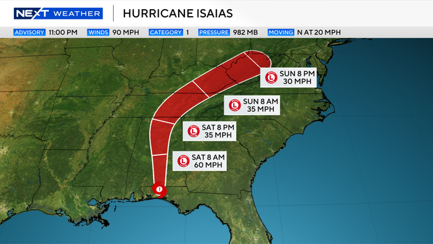
Isaias will bring areas of heavy rainfall to the central U.S., the Gulf Coast, and much of the Southeast through the weekend.
Considerable flash and urban flooding, along with significant river flooding, will be possible.