South Florida could see record-breaking heat to kick off start of 2026 Atlantic hurricane season

It's going to be a hot and steamy start to the month of June with daily chances for some afternoon storms.
A few showers moved across parts of South Florida on Monday morning.
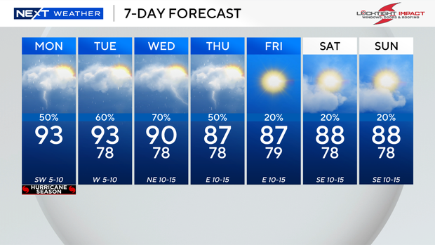
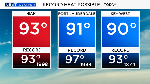
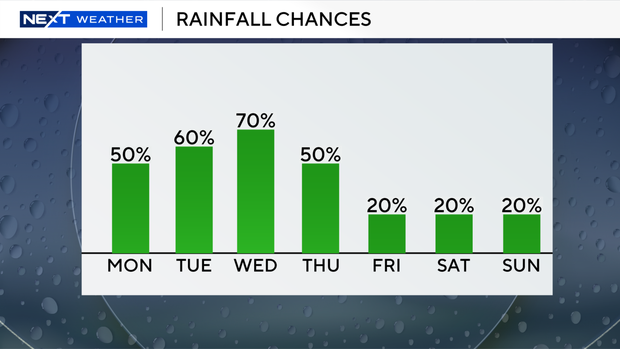
High temperatures will soar into the low 90s on Monday afternoon. With a forecast high temperature of 93 degrees in Miami, we may tie or break the old record of 93 degrees that was set back in 1998.
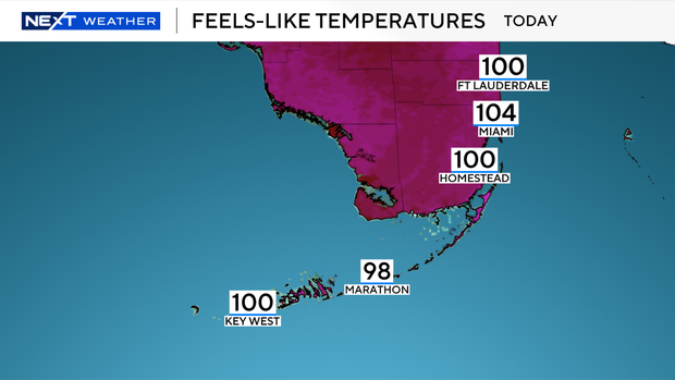
When you factor in the humidity, it will feel like the triple digits. It will also be cloudy and hazy at times due to some Saharan dust.
Scattered thunderstorms will develop with the potential for some heavy downpours.
There is a low risk of rip currents along our Atlantic beaches and there are no alerts of advisories for boaters over the Atlantic waters or the Keys waters.
Rinse and repeat on Tuesday. Keep the umbrella handy as we'll see another round of storms mainly in the afternoon and evening.
Another scorcher is expected on Tuesday as high temperatures remain in the low 90s with feels-like temperatures in the triple-digits.
The chance of rain stays high through Wednesday and Thursday due to plenty of moisture around. Scattered showers and thunderstorms will develop once again with high temperatures in the low 90s.
Drier air arrives later this week to lower the rain chances and lower out temperatures a bit. Spotty showers will be possible on Friday, Saturday and Sunday with high temperatures in the upper 80s.

The 2026 Atlantic hurricane season begins today, June 1, and it will continue through the end of November. NOAA and Colorado State University meteorologists are predicting a slightly below-average season.

Regardless of these forecasts, South Florida residents need to prepare.
The CBS news Miami NEXT Weather team will help you get ready with our hurricane special, "Survive the Season." That airs tonight on CBS Miami at 7 p.m.