Breezy, warm Thursday ahead for South Florida with rip current risk and increasing rain Friday

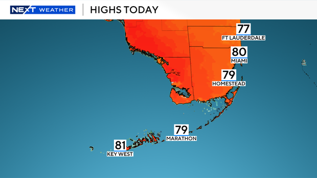
South Florida will see a breezy, warm Thursday with a mix of sun and clouds, highs near 80 degrees and a few passing showers, while a high risk of rip currents remains in effect along Atlantic beaches.
Conditions started comfortably Thursday morning with temperatures in the upper 60s to low 70s as isolated showers moved through on an easterly breeze. Winds are expected to ease slightly through the day, though spotty showers remain possible into the afternoon.
Despite calmer boating conditions across Atlantic waters, a dangerous high risk of rip currents continues along the coast. Boaters in the Florida Keys are urged to use caution.
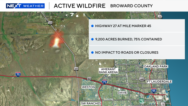
Wildfire in western Broward
Meanwhile, the NEXT Weather team is monitoring a brush fire in the Everglades in western Broward County that has burned about 9,200 acres and is now 75% contained. Easterly winds are pushing smoke westward, keeping air quality conditions good across most of South Florida.
Rain chances increase Friday as a disturbance in the Gulf of Mexico brings deeper moisture into the region, leading to a soggy start to the day before conditions gradually improve in the afternoon. High temperatures will reach the low 80s.
Looking ahead, the weekend will turn warmer with highs in the low to mid-80s and occasional spotty showers. Even hotter weather is expected next week, with temperatures climbing into the upper 80s and limited rain chances.