South Florida warms up before mid-week front brings cooldown

MIAMI - Monday will see a comfortable start across South Florida, with milder low 70s near the coast and cooler low 60s inland.
We are in for a warm-up through midweek. Monday's highs will climb to the upper 70s in the afternoon and some spots will hit 80 degrees under mostly sunny skies. We'll enjoy mainly dry conditions.
There is a high risk of rip currents along the Atlantic beaches and it is not safe to go swimming in the ocean. There are no alerts or advisories for boaters along the Atlantic and Keys waters.
It will be even warmer over the next few days. Lows will be milder in the low 70s on Tuesday and Wednesday morning. Highs will rise to the low 80s in the afternoons. Our warmest day will be on Wednesday when highs reach the low to mid-80s. The chance of rain increases Wednesday with the potential for scattered showers and isolated storms due to our next cold front.
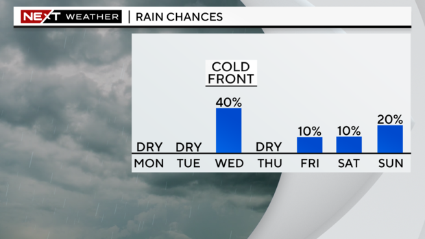
Sweater weather returns Thursday morning. In the wake of that front, lows will tumble to the upper 50s. It will be a chilly start and then highs will only rise to the low 70s. The breeze will build too and it will be windy to blustery at times with gusts as high as 20 to 25 miles per hour late week and through the first half of the weekend.
Friday morning will be cool with temperatures in the low 60s. It will be a little milder in the afternoon with the low to mid-70s. The chance of rain is low but a stray shower can't be ruled out.
This weekend we'll be closer to normal with lows in the upper 60s and highs in the upper 70s. Isolated showers will be possible. Sunday we have the potential for spotty showers.


