Heat index values near 100 expected across South Florida before showers and storms increase this weekend

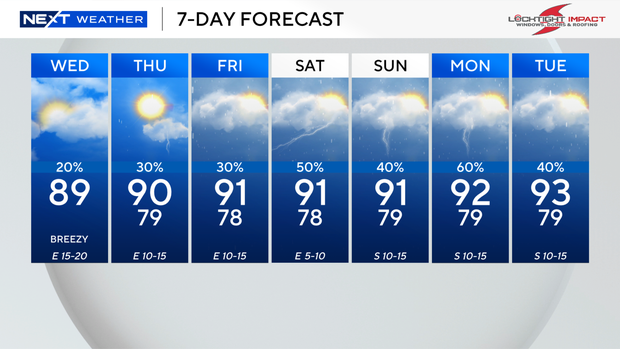
Authorities are urging South Floridians to take precautions Wednesday as another hot and humid day settles across the region, with temperatures climbing to around 90 degrees and heat index values reaching the mid-to-upper 90s, and potentially 100 degrees in some neighborhoods.
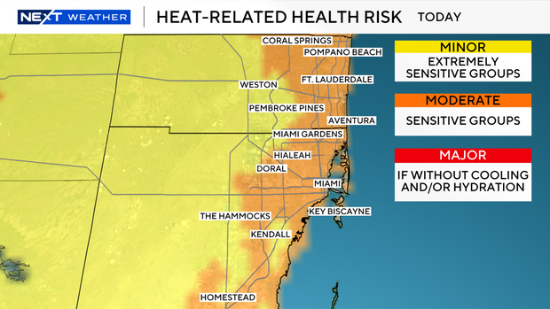
Moderate heat-related health risk is in place for sensitive groups, including older adults, young children and people with underlying health conditions. Residents are encouraged to drink plenty of water, stay hydrated and seek shade or air-conditioned spaces during the hottest part of the afternoon to avoid heat-related illnesses.
A few showers are possible Wednesday morning through the early afternoon hours. An easterly breeze is expected to push most thunderstorms inland and toward Florida's west coast later in the day and into the evening.
Beachgoers should also be aware of a moderate risk of rip currents along Atlantic beaches through at least Friday. The UV index remains very high, increasing the risk of sunburn with prolonged outdoor exposure. No marine alerts or advisories are in effect for Atlantic or Florida Keys waters.
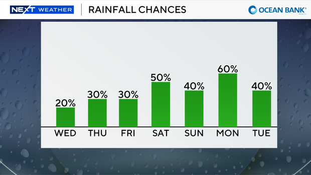
The hot and humid pattern is expected to continue through the end of the workweek, with spotty showers possible Thursday and Friday and highs remaining near 90 degrees.
Rain chances are expected to increase this weekend as deeper tropical moisture moves into the region, bringing a greater likelihood of scattered showers and thunderstorms. It does not appear to be a washout, but residents should expect more frequent rain chances. Temperatures will remain above average, with highs reaching the low 90s on both Saturday and Sunday.
Meanwhile, the tropics remain quiet. No tropical development is expected anywhere in the Atlantic basin during the next seven days.