Center Of Fred Out Of Florida As Grace Now Forecast To Become Tropical Storm On Tuesday
MIAMI (CBSMiami) – The center of Tropical Storm Fred has moved into extreme southeastern Alabama.
As of the 11 p.m. advisory, Fred was 10 miles east of Dothan, Alabama.
Fred is moving toward the north-northeast near 12 mph, and this general motion with an increase in forward speed is expected over the next day or so.
On the forecast track, the center of Fred will move across western and northern Georgia on Tuesday, across the southern Appalachian Mountains on Tuesday night, and into the central Appalachians by early Wednesday.
Maximum sustained winds have decreased to near 40 mph with higher gusts. Additional weakening is expected, and Fred should become a tropical depression overnight or early Tuesday.
Tropical-storm-force winds extend outward up to 45 miles from the center. A wind gust to 53 mph was recently reported at the airport in the Marianna, Florida.
There are no more watches or warnings for Fred.
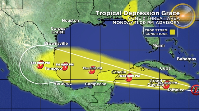
As for Grace, the tropical depression is now forecast to become a tropical storm on Tuesday.
The depression is moving toward the west near 14 mph. A general westward to west-northwestward motion is expected for the next several days.
On the forecast track, the center of Grace will continue to move near or over the Tiburon Peninsula of Haiti during the next couple of hours, and then move between southeastern Cuba and Jamaica on Tuesday.
Grace is forecast to move near the Cayman Islands Tuesday night and then approach the Yucatan peninsula of Mexico late Wednesday or early Thursday.
Maximum sustained winds are near 35 mph with higher gusts.
Strengthening is forecast during the next few days, and Grace is forecast to become a tropical storm on Tuesday.
Further strengthening is anticipated before Grace approaches the coast of Mexico in a few days.
Meanwhile, Tropical Depression 8 became Tropical Storm Henri on Monday.
Henri is moving toward the southwest near 5 mph, and this motion should continue through Tuesday morning.
A turn toward the west is forecast by Tuesday night, and a slightly faster westward motion should continue through early Thursday.
On the forecast track, the center of Henri should pass well to the south of Bermuda late Tuesday or Tuesday night.
Maximum sustained winds have increased to near 45 mph with higher gusts.
Some additional strengthening is possible during the next day or so.
Henri is a small tropical cyclone. Tropical-storm-force winds extend outward only up to 35 miles from the center.