How much rain is coming to Southern California this weekend?

Get ready for big changes brewing into your Easter weekend as our next storm sets up. Make back-up indoor plans for those Easter egg hunts, watch flood & mudslide prone areas as the storm moves in tomorrow night!
A Winter Storm Watch is already in effect for all the mountains in our viewing area starting Friday evening through Sunday night.
A Flood Watch is already in effect for our ENTIRE viewing area Friday afternoon through Sunday night.
Friday Weather:
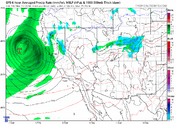
Clouds will increase and with a deep marine layer watch for drizzle in the area. The strong, closed, cold low is very similar to the storm that we saw in February and will be entering our area in the evening. Isolated showers ahead of the system will start to set up late afternoon in the evening, but the first wave of heavy rain doesn't move into Ventura County until 7pm. The heaviest rain will not move in until midnight, but showers will be around.
Saturday Weather:
The heaviest band of rain will move in from Ventura County, to Los Angeles, to Orange County and the Inland Empire starting at midnight and slowly move through the area through 10am making for a very soggy start to the day. We will see rain off and on with a chance for isolated storms Saturday afternoon and evening as winds will gust up to 40mph in some locations as cooler temperatures set in and we don't get out of the 50s.
Another band of heavier rain will move in once again through the area from 3pm to 11pm on Saturday night.
Snow levels will start at 6000 feet and drop rapidly through the day to 4000 feet. We are looking at 1 – 2 feet of snow through the weekend above 6000 feet, then 1" to 6" from 4000, so be prepared for snow on the Grapevine on Saturday evening.
Sunday Weather:
8am – 10am: Showers off and on through the area. We might get some breaks, but best to plan for the rain as the system is right off our coast at this point.
10am – 6pm: Rain, heavy at times, scattered storms with periods of heavy downpours and hail, as well as gusty winds. We will have an unstable environment with the system right off our coastline, so scattered storms can pop up anywhere starting at midnight through the day on Sunday. Snow levels will be at 4000', making mountain roads very dangerous to travel in. Winds in our mountains will be gusting at 60mph.
After 6pm: We will see rain off an on through Sunday evening as the system slowly moves to our south. Rain could continue into early Monday morning, but the system should clear by your morning commute.
Rain Totals For Southern California:
How much rain are we looking getting?
1" – 3" for coast and valleys.
3" – 6" in the foothills and mountains.
More for the areas that see scattered storms.
I know the timing isn't great on this system, so stay safe and make some fun indoor plans!
Meteorologist Marina Jurica