Flash Flood Threat For North Texas As Rain Moves Into The Area
ALERTS/CONDITIONS | WEATHER APP | UPLOAD IMAGES/VIDEO | RADAR
NORTH TEXAS (CBSDFW.COM) — A Flash Flood Watch goes in effect tomorrow morning at 7:00 a.m. and continues until Thursday, October 14 at 7:00 p.m.
A wide swath of heavy rain is expected from the Mexican border in south Texas all the way into Oklahoma. There is currently a moderate risk (20%-50% chance) of rainfall exceeding flash flood guidance.
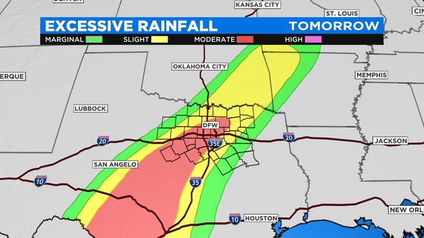
The rainfall potential over the next seven days matches up with excessive rain risk. All this rain falls over the next 72 hours. The heaviest rain is expected starting in the morning on October 13. Several rounds are expected through the day and night. Heavy rain is especially possible overnight into Thursday as the remnants of Hurricane Pamela move into central and North Texas.

Locally as much as 3"-4" could fall in some spots. The forecast models continue to show areas of very heavy rain possible. Below you see four different estimates by four different forecast models we use here in the weather center. All of them show at least an inch of rain at Dallas Fort Worth International Airport or more.
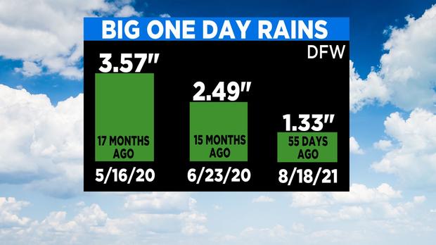
What is interesting to note, DFW Airport hasn't seen many big rain events lately. The last time we had a one-day rain total exceed 3" was 17 months ago. The last time DFW was hit with more than 2" of rain was more than 15 months ago. The last time it rained just one inch or more was a full 55 days ago!
Download our free DFW Weather App to stay aware of any flood warnings issued in your area. Please, please do not take to the roads if your area is under a flood warning. They usually only last a few hours at the most. Wait. Remember that more than half of all flooding deaths occur in the nighttime in automobiles. Turn around, don't drown.