DFW Weather: Dangerous Travel Conditions Ahead With Snow, Ice Expected Throughout North Texas
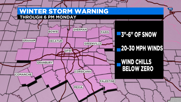
(CBSDFW.COM) - A Winter Storm Warning continues until Monday night.
It was very nice to have some sun Saturday as it helped clear away the morning icing. We hope you enjoyed it as we have a major winter event starting to unfold Sunday night.
Roads became icy and snow-covered overnight Sunday morning.
Travel will be very hazardous.
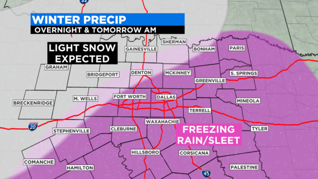
By 4 p.m. to 6 p.m. Sunday, the snow will become heavy.
Strong north winds (25 to 30 mph) will create near blizzard-like conditions. Visibility could fall below a quarter a mile at times.
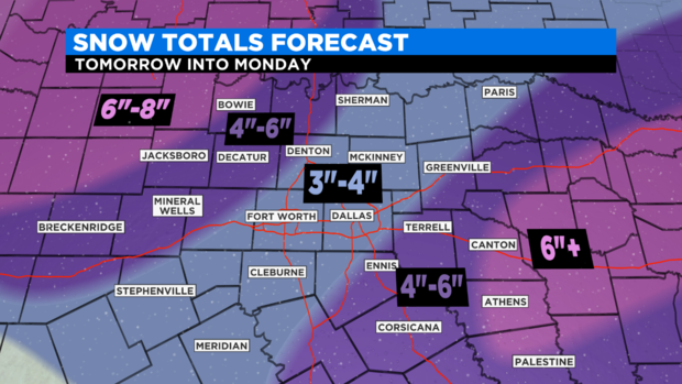
This snow will quickly accumulate on the roadways, and we are only expecting a high in the low 20s. It will be falling on areas of ice. We are expecting three to four inches of snow within the Metroplex, which is the biggest snow in five years.
Wind chills will drop down into the negative numbers by Sunday night and reach all the way down into the negative teens by Monday morning. The combination of dangerous cold and snow-packed roads with ice will create a deadly combination for drivers.
Please do not attempt to travel starting late Sunday and Monday.

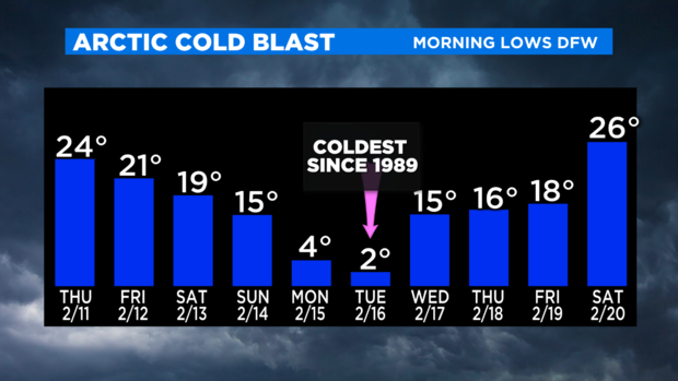
We will have historical cold. Record lows are anticipated both Monday and Tuesday morning, some of these records are over a hundred years old.
Other points to make:
1) We are not expecting a major ice snow. The potential of significant icing on power lines looks to be small. Rolling blackouts from record power demand will be a more likely threat to losing electricity at your house.
2) Snow packed roads with ice underneath will be a problem for most of the week ahead.
3) The coldest night will be Tuesday morning, the low will get close to zero at DFW Airport
4) We are expecting below-freezing temperatures all the way until mid-day Friday.
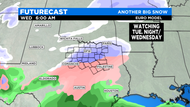
Another snow event is expected Tuesday night into Wednesday morning. This second winter storm in three days could bring a major icing event to our southern counties and more accumulating snow for the Metroplex.
This will again make for hazardous travel conditions for Wednesday and Thursday.
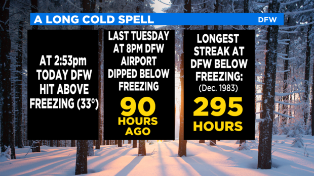
Please protect the elderly and those who might not be able to keep warm enough. We have fallen below freezing Saturday night and will likely stay below freezing all the way to Friday mid-day.
Protect your pets by keeping them indoors, especially at night. Protect your pipes; this will be the coldest air in 32 years in the Metroplex. Many houses standing today are younger than that