Severe weather possible Tuesday in Southeast Michigan. Here's the timing and what to look for.

A severe weather threat exists for Tuesday, and Southeast Michigan is squarely in the path.
A potent weather system is dragging unseasonably warm, humid air into the Great Lakes. While areas further west will see the initial stronger thunderstorm development, those storms are expected to merge and take aim at our area as the sun goes down.
If you live in Metro Detroit, Tuesday is a crucial day to be weather-aware, particularly as we head into the overnight hours. It's why the CBS News Detroit weather team has declared Tuesday to be a NEXT Weather Alert Day.
Here is what you need to know to stay safe and ahead of the storms here at home.
Flood watch
Because of excessive rainfall in the forecast, the National Weather Service in Detroit issued a flood watch for all of Southeast Michigan, with the flood watch in effect from 8 p.m. Tuesday through late Thursday night.
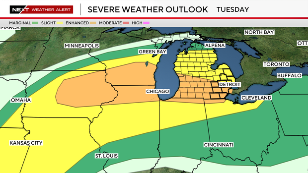
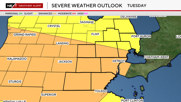
Severe weather setup
The National Weather Service Storm Prediction Center has placed all of Southeast Michigan into the "enhanced risk" (level 3/5) for severe weather on Tuesday.
The reason is that as a warm front lifts through Southeast Michigan on Tuesday, it will dramatically destabilize our atmosphere, setting the stage for a rough Tuesday night.
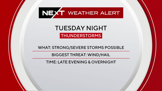
As a bowing line of storms sweeps into our area from the west Tuesday night, the main danger will be straight-line wind gusts of up to 60 mph. These winds will be capable of snapping tree branches and downing power lines.
While the highest tornado risk remains to our west during the afternoon, we cannot rule out quick, line-embedded spin-up tornadoes as the squall line moves through, including during the overnight hours.
Hail of 1 to 2 inches is possible, particularly if any isolated, discrete storms manage to develop ahead of the main line during the early evening.
Heavy rainfall is another primary concern, as some low-lying or urban flooding is possible beneath any continued rain.
Severe weather timing
Through the mid-to-late afternoon, a warm front will push north across the area.
During this window, we will be watching closely for any isolated storms that try to pop up in the warm, humid air across Wayne, Oakland, and Macomb counties. If a storm can tap into this energy early, it could pose an isolated severe risk.
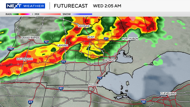
The most significant and widespread threat arrives after dark. A powerful low-level jet stream will force the storms to our west into a severe squall line.
This line will race eastward across the state, pushing through southeast Michigan. Because this line is expected to arrive late Tuesday evening and persist into the early morning hours of Wednesday, the primary danger will be damaging wind gusts.
While normally the late hours of these storms would help to weaken them, and that is still a possibility, the overall fuel available may be enough to keep our storm risk going.
Overall, the main storm risk seems to be between 8 p.m. and 2 a.m. Tuesday night into Wednesday morning.
Preparations
Nighttime severe weather can be understandably scary.
When storms hit while most of the viewing area is asleep, it's important to be able to get alerts. Do not rely on outdoor warning sirens to wake you up indoors.
Ensure your smartphone is enabled with wireless emergency alerts (WEA) and keep your ringer on loud. A NOAA Weather Radio with a battery backup is the most reliable way to be woken up for a tornado or severe thunderstorm warning.
Before you go to bed tonight or before you leave for work on Tuesday, secure patio furniture, trash cans, and any loose yard items. It's been nice out the past few days, so a lot of those patio sets and umbrellas are outside now.
Identify the lowest, most interior room of your home, away from windows, such as a basement, closet, or interior bathroom, so you aren't figuring it out in the dark.
Stay informed with CBS News Detroit
Should circumstances warrant, the CBS News Detroit weather team will livetrack the storm. You can follow the reports on air, online, on our mobile app and on our social media accounts such as YouTube.
If you wish to share photos or videos after a storm passes through, please join our Weather Watcher Network.