Rare 'high risk' storm alert issued for parts of Midwest and Mid-South including potential for violent, long-track tornadoes
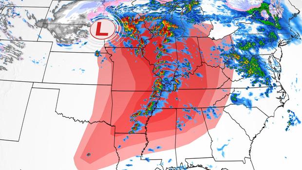
(CNN) -- A rare "high risk" Level 5 out of 5 alert has been issued for two regions and will impact nearly 3 million people, the National Weather Service's Storm Prediction Center said Friday.
High risk areas include portions of southeastern Iowa, northwestern Illinois and northeastern Missouri, and includes places like Davenport, Iowa, and Iowa City. The second area is farther south and includes portions of eastern Arkansas, northern Mississippi and southwestern Tennessee. Memphis, Tennessee, is included in the high risk area.
"Environmental conditions are quickly becoming favorable to support the potential for numerous strong to potentially violent and long-track tornadoes," the center said.
High risk days are exceedingly rare and are "reserved for when high confidence exists in widespread coverage of severe weather with embedded instances of extreme severe" weather such as violent tornadoes or extreme damaging winds, according to the storm center.
The last Level 5 high risk day occurred on March 25, 2021, when numerous tornadoes were reported across the Southeast.
Additionally, severe storms are expected to sweep across some central and southern states beginning Friday afternoon, bringing the threat of several strong tornadoes, large hail and damaging winds to nearly 90 million people across 21 states.
A tornado watch has been issued for portions of eastern Iowa, western Illinois, northern Missouri and southwestern Wisconsin. This tornado watch has been labeled a "particularly dangerous situation" by the Storm Prediction Center.
"Parameters are favorable for the potential for strong/violent tornadoes and very large hail," the storm center said.
Know the difference between a tornado watch and tornado warning
A moderate, Level 4 of 5, risk of severe storms stretches from northern Mississippi to Iowa, including Indianapolis, Indiana, Little Rock, Arkansas, Des Moines, Iowa, and St. Louis.
"At least a few long-track, strong to potentially violent tornadoes are probable, particularly over portions of the Mid-Mississippi Valley to the Mid-South," the Storm Prediction Center said. "Swaths of intense damaging wind gusts along with very large hail are expected as well."
Some of the tornadoes may be EF-3 or higher, meaning they would have winds of at least 136 mph.
Overall, the moderate risk area covers 10 million people.
"We are concerned about strong tornadoes and widespread damaging winds," Bill Bunting, chief of forecast operations at the Storm Prediction Center, told CNN, noting the storms will be fast-moving. "We've been trying to stress, don't wait until you see visual cues of the storm approaching, take action when warnings are issued."
"Residents are advised to remain weather-aware and have multiple ways to receive weather alerts," the Weather Prediction Center said. "Along with the severe weather threat, storms may also contain intense rainfall rates that could last long enough to produce isolated-to-scattered areas of flash flooding."
The severe weather outbreak is expected to begin Friday afternoon and go into the evening, forecasters said. Tornadoes or severe storms occurring at night have the greatest potential to be dangerous because people are less likely to be notified in time if they're asleep.
Last week, an overnight tornado leveled nearly the entire community of Rolling Fork, Mississippi, where estimated maximum winds of 170 mph roared through. In total, at least 26 people were killed and dozens injured as the powerful storm system moved through the Southeast.
Meanwhile on Friday, a slightly weaker enhanced risk for severe storms, Level 3 of 5, is in place for areas including Chicago, Nashville, Tennessee, Cincinnati, and Louisville, Louisiana. The main threats are isolated long-track tornadoes, damaging winds and large hail.
A Level 2 of 5 slight risk of severe storms extends into the Ohio and Tennessee Valleys and includes Columbus, Ohio, Kansas City, Missouri, and Milwaukee.
There is also a marginal risk of severe storms, Level 1 of 5, that extends from northeastern Texas to southern Minnesota and east to Michigan and West Virginia.
Cities under that alert are Dallas, Detroit, Cleveland and Atlanta. The main threats are isolated tornadoes, high winds and isolated large hail.
'Now's the time' to make a severe weather plan
Some of the areas still cleaning up from last week's storms could face more severe weather Friday, and forecasters warn the conditions could be intense.
"The fact that you missed the worst storm last week doesn't mean that that fortune will hold Friday," Bunting said.
"We've seen these patterns before where there is just a repeat of severe weather in generally the same area," Bunting said. "We can't change past outcomes, but what we can do is encourage everyone to be ready for the next one."
Bunting stressed that having a plan before the storm strikes could save your life.
"We've just been trying to encourage people to, if you don't, have a severe weather plan. If you've never thought you needed one, we're in an active situation that's going to continue to be active next week, now's the time."


