El Niño to bring warmer end of summer and fall to the Great Lakes

If you feel like the weather has been a bit "all over the place" lately, you aren't imagining it.
As we leave the spring thaw behind and look toward the summer of 2026, Southeast Michigan is sitting in a unique atmospheric holding pattern known as ENSO-neutral.
But don't get used to the middle ground.
Global climate models are sounding the alarm for a significant shift: a new El Niño is expected to take charge by the end of the year.
Here is what that means for our backyard, from the summer humidity to the winter snow shovels.
Summer under the "neutral" wild card
Currently, we are in an ENSO-neutral phase, meaning neither El Niño (warm) nor La Niña (cool) is dominating the tropical Pacific.
While that might sound "calm," for us in the Great Lakes, it often means the opposite.
Without a strong signal from the Pacific to steer the jet stream into a predictable path, the atmosphere becomes more volatile.
Historically, neutral setups in Southeast Michigan are synonymous with active weather.
Neutral phases often allow the jet stream to "wobble" directly over the Midwest, opening the door for frequent low-pressure systems.
Because the pattern is less "blocked," we often see more frequent rounds of thunderstorms and heavy rain events during the summer months.
Without a dominant driver, long-range forecasts can be trickier, leading to more systems that develop quickly.
Essentially, expect an early summer that stays busy.
We'll likely see plenty of opportunities for rain to keep the lawns green, but we'll also need to keep a close eye on the radar for those active storm tracks.
The El Niño arrival: Fall and winter 2026
The "neutral" status won't last.
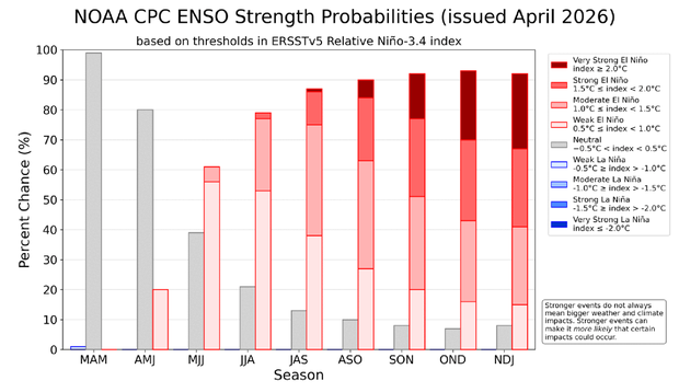
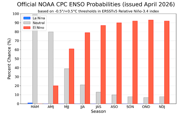
The latest data from the Climate Prediction Center indicates a 61% chance of El Niño emerging between May and July, likely strengthening rapidly as we head into the fall.
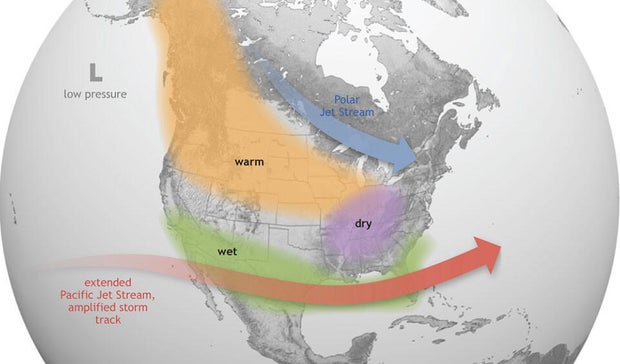
When El Niño takes the wheel, the script for Southeast Michigan weather usually gets flipped.
For our region, a classic El Niño pattern typically brings two main ingredients: warmer and drier conditions.
In some years, downright hot.
So what does that mean for later this year and into the winter?
El Niño usually pushes the polar jet stream further north, keeping the most brutal Arctic air bottled up in Canada.
This often results in a "milder" winter with more days above freezing than usual.
Because the storm track often shifts to the Southern U.S. during El Niño years, the Great Lakes frequently miss out on the big storms and moisture-rich systems.
This typically leads to below-average snowfall totals for Metro Detroit.
The trend toward drier weather often starts as early as late autumn, potentially leading to a brown start to the winter season.
We are entering a transition year.
As always, while these global patterns give us a "lean" on what to expect, Michigan weather loves to throw a curveball.
Stay tuned to our latest forecasts as we track them day to day.


