Snow set to blanket Colorado, below 0 wind chills expected in Denver and other parts of Front Range

A cold and snowy stretch of weather is headed to Colorado. Accumulating snow is expected in Denver and across the Eastern Plains Tuesday night into Wednesday.
Arctic blast arrives Monday night, snow by Tuesday
An arctic blast will push through the state Monday bringing colder temperatures and light snow overnight. Weak upslope is expected into the early hours of Tuesday bringing the chance for light snow accumulations for much of the Front Range. Very little impact to the Tuesday morning commute is expected, except possibly in some parts of the northwestern part of the Denver metro area.
Downright frigid air lags behind Monday's cold front. People stepping outside on Tuesday morning should be ready for wind chills below 0. Actual temperatures will rise to the 20s, but this is just the start of cold days and nights.
Light snow will spread across much of the state during the afternoon and evening, continuing into Wednesday.
Light, fluffy snow piles up Wednesday morning
Light snow will continue through 11 a.m. on Wednesday. I'd plan for a slick commute and major delays on Colorado's interstates, including I-25 and I-70.
Winter Weather Advisories have been posted and will go into effect at 2 PM on Tuesday until 11 AM Wednesday.
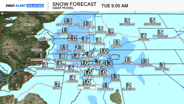
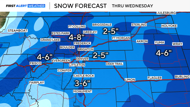
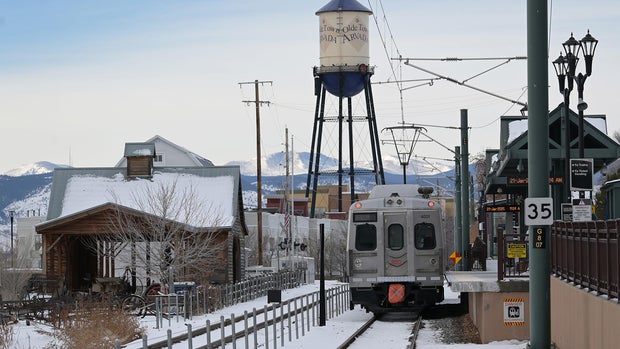
As of now it is looking like widespread 2-5 inches on the Eastern Plains, 4-8 inches in the foothills and for a portion of the Interstate 25 corridor north of Denver, as well as 4-10 inches for the high country including Vail Pass and the Eisenhower-Johnson Memorial Tunnel.
Highs will top out in the teens on Wednesday with wind chills as low as 15 degrees below 0. Frostbite can occur on exposed skin in as little as 30 minutes, so if you'll be outside at all bundle up.
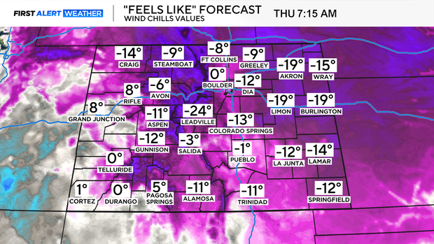
Coldest night of the Arctic blast, dangerously cold Thursday morning
Lows will drop below 0 degrees late Wednesday and out the door early Thursday morning. Wind chills will bottom out as low a 20 degrees below 0.
Layering of clothing will be necessary on Thursday. By the afternoon, temperatures will get above the freezing mark, followed by 48 degrees on Friday -- Valentine's Day.
Another round of heavy mountain snow is expected Friday and Saturday. Snow showers will spill across the Eastern Plains on Saturday resulting in another round of accumulating snow.