Some of Colorado should see a snowier-than-average winter; find out how Denver will stack up

What kind of winter will we have in Colorado? We are starting to get a better idea, and the First Alert Weather Team has released their official forecast below.
What winters can we use for comparison?
We are currently in an El Niño, and the forecast suggests it will only get stronger, with a 75% chance of becoming one of the strongest El Niños on record.
Before we get into the comparison years, here is the simplest way to understand what is happening.
El Niño usually gives Colorado a better shot at a snowier pattern. But another pattern in the Pacific Ocean, called the PDO, is working against that classic setup this year. That could make the storm track less consistent and lead to bigger swings between warm, dry stretches and colder, stormier periods.
The PDO stands for Pacific Decadal Oscillation, and it has to do with water temperatures in the northern Pacific Ocean. The important part is that a positive PDO tends to work better with the classic strong El Niño pattern, while a negative PDO can make that pattern less reliable.
The three very strong El Niño winters we've been looking at due to their similarities are 1982–83, 1997–98, and 2015–16. They've all had something this winter likely won't: a positive winter PDO.
When creating the forecast for this upcoming winter, we're placing heavy weight on those big three because each of these El Niños was very strong. All three also featured a positive PDO, and all three produced well-above-average Denver snowfall.
This potentially historic El Niño is not expected to feature the helpful positive PDO. Let me say the truth about this: it throws a big wrench in the forecast. We almost had it "easy" this year. If the PDO were positive, I would have a lot more confidence in a snowier-than-average winter across all of Colorado.
So, let's plot all winters with a moderate El Niño or greater and a negative PDO:
Winter | El Niño | Nov–Mar PDO avg. | Denver snowfall | vs. 56.6" avg. |
1965–66 | Moderate | −0.22 | 46.9" | −9.7" |
1968–69 | Moderate | −0.44 | 33.3" | −23.3" |
1972–73 | Strong | −0.37 | 94.9" | +38.3" |
2009–10 | Strong | −0.25 | 60.6" | +4.0" |
2018–19 | Moderate | −0.48 | 48.1" | −8.5" |
2023–24 | Strong | −1.51 | 44.6" | −12.0" |
In my opinion, the two years that really stick out are 1972-73 and 2023-24. Both years had a strong El Niño and a negative PDO. So, where does that put us?
72/73: 94.9" of snow
23/24: 44.6" of snow
And this is where the forecast gets difficult. Two of our closest comparison years went in completely different directions. My takeaway is that the negative PDO doesn't cancel the strong El Niño; it just increases uncertainty. The door remains open for a very snowy winter, but there is also a legitimate bust scenario if storm tracks are less favorable or if storms repeatedly fail to line up with the cold air.
When I run the same data for one point in each quadrant of the state, a clear pattern emerges.
Representative site | Region | Analog avg. vs. normal | Above normal |
Steamboat Springs | NW | 93% | 2 of 6 |
Denver | NE | ~97% | 2 of 6 |
Colorado Springs | SE | 137% | 4 of 6 |
Mesa Verde NP | SW | 162% | 5 of 6 |
The 2026/2027 Winter Outlook
Southern Colorado is clearly favored for higher confidence in heavier snow. One important note: both analog averages are close to 100% in northern Colorado (Denver and Steamboat Springs) because one HUGE snow year significantly pulls up the average, despite four of the six years finishing below average.
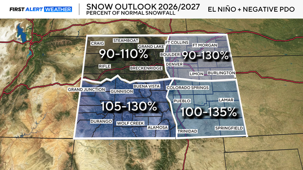
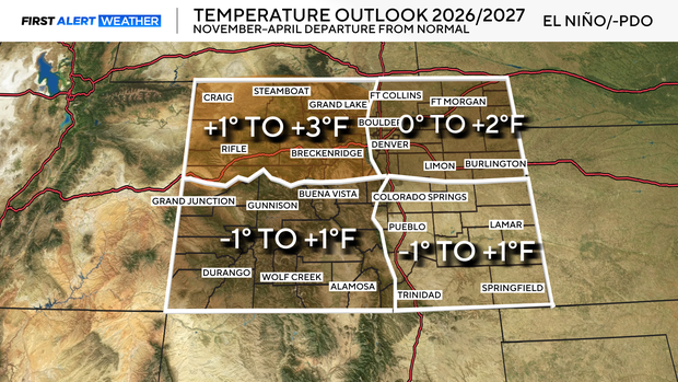
Here are a few things to help you understand what this fall and winter may look like.
A volatile winter is expected, one of those winters with warm stretches followed by rounds of Arctic air. With that said, I will not be surprised if we hit an extended period of temperatures well above where they typically are. That is expected. I would also not be surprised to see several rounds of frigid Arctic air overstay their visits.
The point is, I do not expect this winter to stay on one side of normal for very long. There will likely be stretches where it does not feel like winter at all, followed by sharp flips into very cold weather. That temperature whiplash is a big part of this forecast.
Southern Colorado is the clear favorite for a wetter and snowier season. Northern Colorado is much less certain, with a greater chance of finishing closer to normal or below normal if the storm track repeatedly misses.


