Lack of snow cover in Colorado foothills leaves brush piles sitting instead of burning

They look like beaver lodges sitting on a mountainside -- hundreds of them.
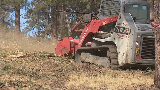
But they are, instead, burn piles consisting of brush cleared in mitigation efforts in Colorado's foothills. There are thousands of them in the foothills counties awaiting controlled burns.
"Ready to burn, and it's unfortunate that the weather is not cooperating because the agencies and partners are ready to go," said Jen Hoogendoorn, and Evergreen homeowner.
Hoogendoorn worked with other people in her neighborhood in Clear Creek County to mitigate property in their area. A contractor did some of the work. Nearby Denver Mountain Parks owns land and cleared trees and shrubs to reduce fire risk. Those piles sit too.
"I border Denver Mountain Parks land and other public land, and the amount of dead trees and the amount of dangerous areas are ridiculous," Hoogendoorn explained.
Fire departments and counties along the Front Range have been working on increased mitigation for years. But in the era after costly fires, it's gained new importance.
"We were really ramping up this year with the crews that we built and the burn plans that we had supported," said Brian Keating, Jefferson County's wildland fire program manager . "Ready to ramp up and hit those piles hard this year, and we've had one day where we able to do some pile burning."
That's because burning burn piles requires snow cover and low winds along with the proper humidity levels. They require extensive paperwork and technical review.
"That sets the conditions, which we feel that we can mitigate the risk of those prescribed fires potentially escaping," Keating said.
The county and its fire districts and partner agencies, including JeffCo Parks & Open Space, are doing more mitigation as the fire danger increases to year-round. Keating says there are priorities like communications towers and power line corridors, traffic effects, critical highways and the locations of schools and care centers as well as watersheds.
The warm winter has thrown a new problem at planning.
"Our conditions are changing," Keating said. "Every year, we're like, 'We've never seen fire behavior like that, or we've never seen conditions like that.'"
That is certainly the case this winter.
"This is the lowest snowpack we've ever had, and to go for months without any kind of measurable precipitation is really unusual," Keating said. "That doesn't bode well moving into the summer when we get into our normal patterns."
This winter, the lack of snow has meant that high grasses are not being pushed down as they are under snow.
"Right now if you drive around anywhere in the Front Range, the grasses are still standing up," Keating explained. "So, when we have just a little bit of wind and an ignition source, that supports large fire growth real fast."
Those kinds of changes are part of the reason that Jefferson County's wildland urban interface map includes a change in the amount of area now deemed as at-risk. In the past, it has been 71% of the county in areas above 6,400 feet of elevation. It now includes 91% of the county and areas lower elevation, where risk was not considered as significant.
In areas like Evergreen, people are judging daily weather for its fire potential.
"It's frightening, and I think everyone's a little bit on edge with all the red flag warning days and this wind," Hoogendoorn said. "Everyone is on edge and worried about the worst case scenario, and this doesn't help."
Regarding dry, warm weather Friday, Hoogendoorn said, "It's like climate chaos is in effect, and it's troubling. I sure would like to see some snow and frozen ponds and safety around these parts of high fire danger."