High-tech mapping reveals extent of Colorado's low snowpack

If you've flown west out of Denver, you've had a spectacular view out your airline window of Colorado's incredible high mountains. In the summer, there are patches of white and red and brown rock mixed with deep green forests.
In the winter, soft white drapes over the peaks. At least, usually.
This year, with a historically low snow pack reaching into late April, it's looked a lot different.
"I think it comes as no surprise to all of us that it is a historically low snow year," said Jeff Deems, co-founder of Airborne Snow Observatories. "We've been able to put some color on that and figure out exactly where the snowpack is that we do have. Which is really important for us to get a bead on how much water we'll have available later in the summer."
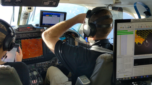
The company flies twin-engine aircraft equipped with lidar and spectrometers to measure snow depth and snow content to create high-resolution maps for water utilities and government, as well as other scientific investigations. Blue represents the deepest snow on their maps, yellow moderate, red shows a reduction in snow from mapping done in previous years. This year, there's a lot of red.
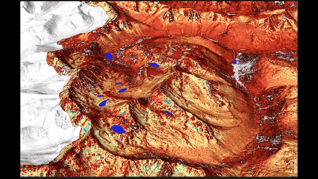
Deems pointed out that snow on the high peaks is certainly helpful, but it's not the big boost to snowpack that some might believe.
"If you put a foot of snow on the high peaks versus a foot of snow down lower, there's so much more terrain at lower elevation. That foot of snow down low adds up to a lot more water than just on the high peaks."
Snow arriving in the high mountains on Wednesday was welcome news.
"We're hoping for a continued wet and snowy and rainy spring, and then for a good monsoon season this summer to keep things topped up," said Deems.
Colorado has had for decades a series of measuring stations that help show snowpack. Some stations have data back more than 100 years. Airborne Snow Observatories grew out of research at NASA's Jet Propulsion Laboratory. The technology helps show snowpack in areas beyond measuring stations. The company contracts with Denver Water and other water utilities so they can get the best data available.
"We are in rough shape, and, you know, we'll take whatever that storm will give us and the next one. But really what we're able to do is provide the most granular information possible so that, say, Denver Water's managers can really plan for how much water they're going to have in Dillon Reservoir, or in Gross Reservoir," said Deems.
Last year, Colorado approved the aerial snow monitoring and forecasting program, part of the statewide water agency, the Colorado Water Conservation Board.
They have learned that not only is snow depth, but the snow location and content are part of the issues with the state's snowpack. Snow does remain longer in shady and north-facing spots. But that's not all.
"Later in the summer, those north-facing areas and those big avalanche deposits that are hiding up in the northern, north-facing terrain.
Those are our late-season water supply," explained Deems. Dust that has gone airborne can make the snow darker. That in turn, can speed evaporation and sublimation, which is the snow turning directly from a solid to a gas without turning to liquid. "Really, the sun is our major snow melter. So when it's out and shining, it's the thing giving the most energy to melting the snow," he added.
This snow season, there was what Deems remarked was a pretty normal amount of snow in late Fall and at the start of winter. But then things changed.
"A lot of that came in pretty warm, such that it fell as rain at low elevations. So our snowpack that did develop, developed mostly at middle and upper elevations. And there's a lot of area down at low elevations that, even though it doesn't develop a big, thick snowpack, that's still a lot of snow in a typical year. We were missing that this year."
As rain developed along the Front Range on Wednesday and snow in the high country, there was hope. Dropping temperatures would help keep it from melting quickly. And aerial observations may help show just how good it is.
"Fingers crossed for a cold storm and for some good dynamics," Deems said.