Taste of fall arrives in Colorado with daily storm chances this week

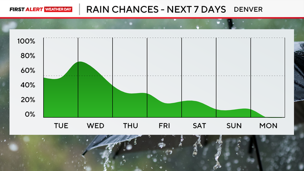
A taste of fall settles in across Colorado starting Monday and lingers through much of the week. Unsettled weather is possible each day, but the setup will be tricky. Here's a breakdown of storm chances day by day to help plan for your week:
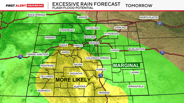
Monday: The best chance for rain will be along much of the Interstate 25 corridor. Flash flooding will be a concern over recent burn scars, with localized flooding possible in lower elevations.
Tuesday: Moisture remains in place over the Front Range and Eastern Plains, but an upper-level ridge will try to suppress storm development. These two factors will battle through the day, leading to scattered showers statewide. Storms are most likely in the high country where the terrain forces air upward.
Wednesday: The pattern looks similar to Tuesday, but the ridge shifts south and weakens. That gives storms a better chance to survive as they drop east into the I-25 corridor. Widespread moderate to heavy rain is possible with a very moist air mass in place. The question is how many storms can make it off the higher terrain.
Thursday and Friday: Moisture begins to decrease as the ridge settles over the southern Rockies. Storms will still form in the high country and try to drift east, but low clouds could cap the atmosphere and shut storms down. Thursday has the biggest "boom or bust" potential. By Friday, activity looks more typical of late summer: very isolated afternoon showers.