Denver Weather: Heading Into The Deep Freeze For 3 Days With More Snow!
DENVER (CBS4) - Snow similar to recent storms in Denver will fall late Tuesday into Wednesday. The difference this week will be the extreme cold that accompanies the snow. Temperatures will likely stay below freezing in the metro area for more than 3 days.

The CBS4 weather team has declared a First Alert Weather Day for both Tuesday and Wednesday because of the expectation of significant impacts from either snow, cold, or both along the Front Range and across Colorado.
Before the storm arrives, Monday will be a continuation of the weekend with relatively mild temperatures in the 50s and completely dry weather.
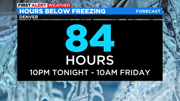
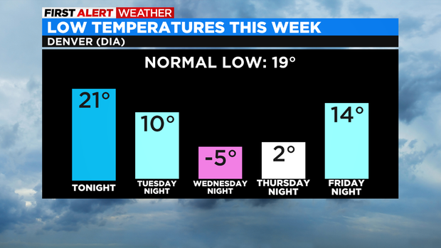
Then the first of two cold front's will arrive early Tuesday so the final above freezing temperature in Denver expected around 10pm Monday. Then temperatures will plummet and remain below freezing for about 84 hours (until about 10 a.m. Friday).
The days will be very cold especially on Wednesday and Thursday and the overnight lows will be frigid. The coldest temperatures are expected Wednesday night into Thursday morning with all neighborhoods along the Front Range expected to drop below zero.
In terms of snow, it will initially develop in the mountains during the day on Tuesday and then move east onto the urban corridor mostly after 5 p.m. Tuesday. Then snow will continue through Tuesday night and into Wednesday morning before ending later in the day on Wednesday.
The heaviest snow accumulation will be in the foothills of Jefferson, Boulder, and Larimer Counties where 6 to 12 inches is expected. For areas between the foothills and I-25 such as Littleton, Lakewood, Arvada, Golden, Boulder, Loveland, and Fort Collins, total snow accumulation is expected to be 4 to 9 inches. Areas east of I-25 (except Douglas County) including Aurora, Brighton and Greeley, total snowfall should range between 2 and 5 inches. Locations in Douglas County including Parker and Castle Rock should also get 4 to 9 inches of snow.

Elsewhere around the state, most of the Eastern Plains will get 1-4 inches of snow while most mountain areas north of Highway 50 only get 2 to 6 inches. So it's entirely possible Denver could get more snow than many of Colorado's ski resorts for at least the third straight storm.
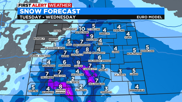
The southern mountains should do better with up to 18 inches of snow for the San Juan and Sangre de Cristo Mountains.
The snow will end statewide Wednesday night. Thursday will remain very cold before temperatures gradually climb through the weekend. That said, it will stay colder than normal in Colorado through at least Sunday.