Denver Weather: Incoming Storm Set To Produce Deep Spring Snow In Some Areas
DENVER (CBS4) - A storm moving into Colorado on Wednesday will spread snow across the mountains before bringing rain and then snow to Denver and the Front Range.
The CBS4 Weather Team has issued a First Alert Weather Day for Wednesday night and Thursday due to winter travel conditions especially south and west of Denver.
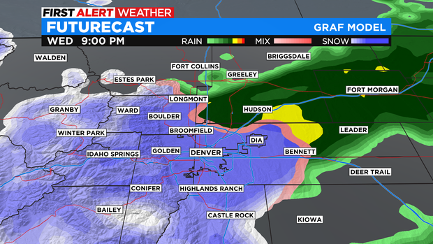
Rain showers are possible around Denver, Boulder, and Fort Collins as early as 2 p.m. Wednesday but most of the rain will wait until closer to 5 p.m. Once the showers begin, the precipitation should stay rain for at least a couple hours.
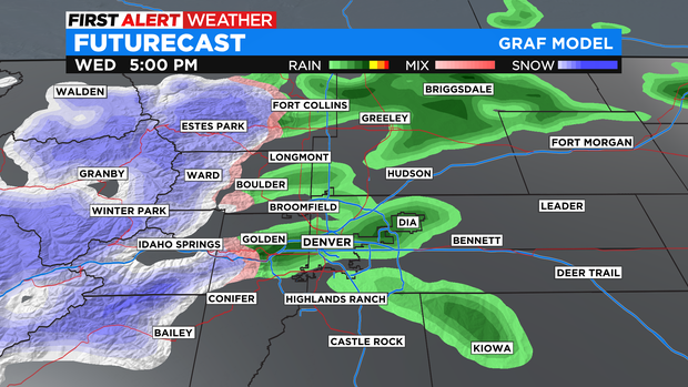
Through about 7 p.m., almost all of the precipitation along the I-25 urban corridor should still be rain while areas in the foothills will have already seen a transition to snow.
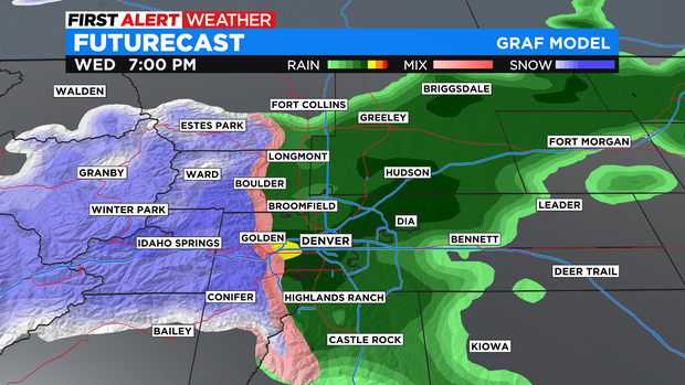
By 9 p.m., the entire Denver metro area will have seen the rain change into snow but areas in northern Colorado including Fort Collins, Greeley, and Fort Morgan may still have rain until closer to midnight.
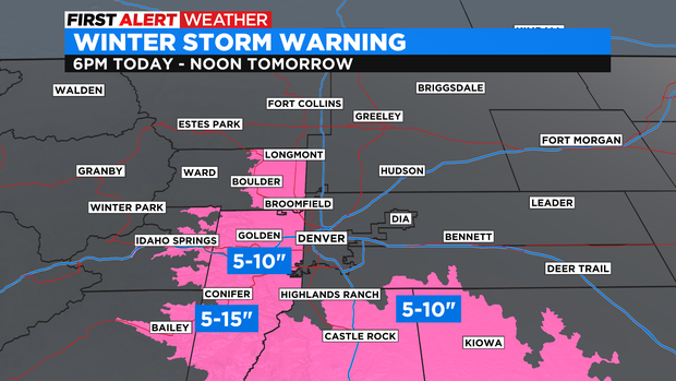
A Winter Storm Warning starts at 6 p.m. for Boulder, the western suburbs of Denver, the southern foothills, and the Palmer Divide in Douglas and Elbert Counties. Most of these areas will see 5-10 inches of heavy, wet snow Wednesday night but some areas mainly above 7,000 feet in Jefferson and Boulder Counties will get up to 15 inches.
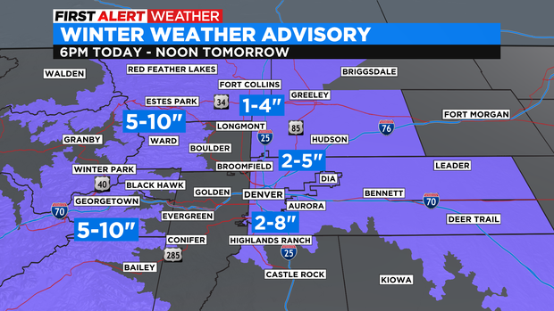
For the rest of the Denver metro area including the eastern and northern suburbs as well as the Fort Collins, Loveland Greeley areas are under a Winter Weather Advisory starting at 6 p.m. The heaviest snow will be south of I-70 and west of I-25 where up to 8 inches is possible. Elsewhere, most areas will see 1-5 inches with the lowest amounts near DIA across Weld County,
For the mountains, Summit County, Winter Park, the Rocky Mountain National Park region will get 4-10 inches of snow. Amounts will be less west of Vail Pass. The Sangre de Cristo Mountains in southern Colorado are also under a Winter Weather Advisory for 3-6 inches of snow.
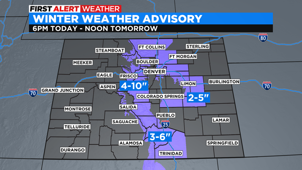
The other other advisory in Colorado is for the Colorado Springs area where 2-5 inches of snow is expected south of the Air Force Academy (amounts will be much higher along I-25 closer to Monument Hill).
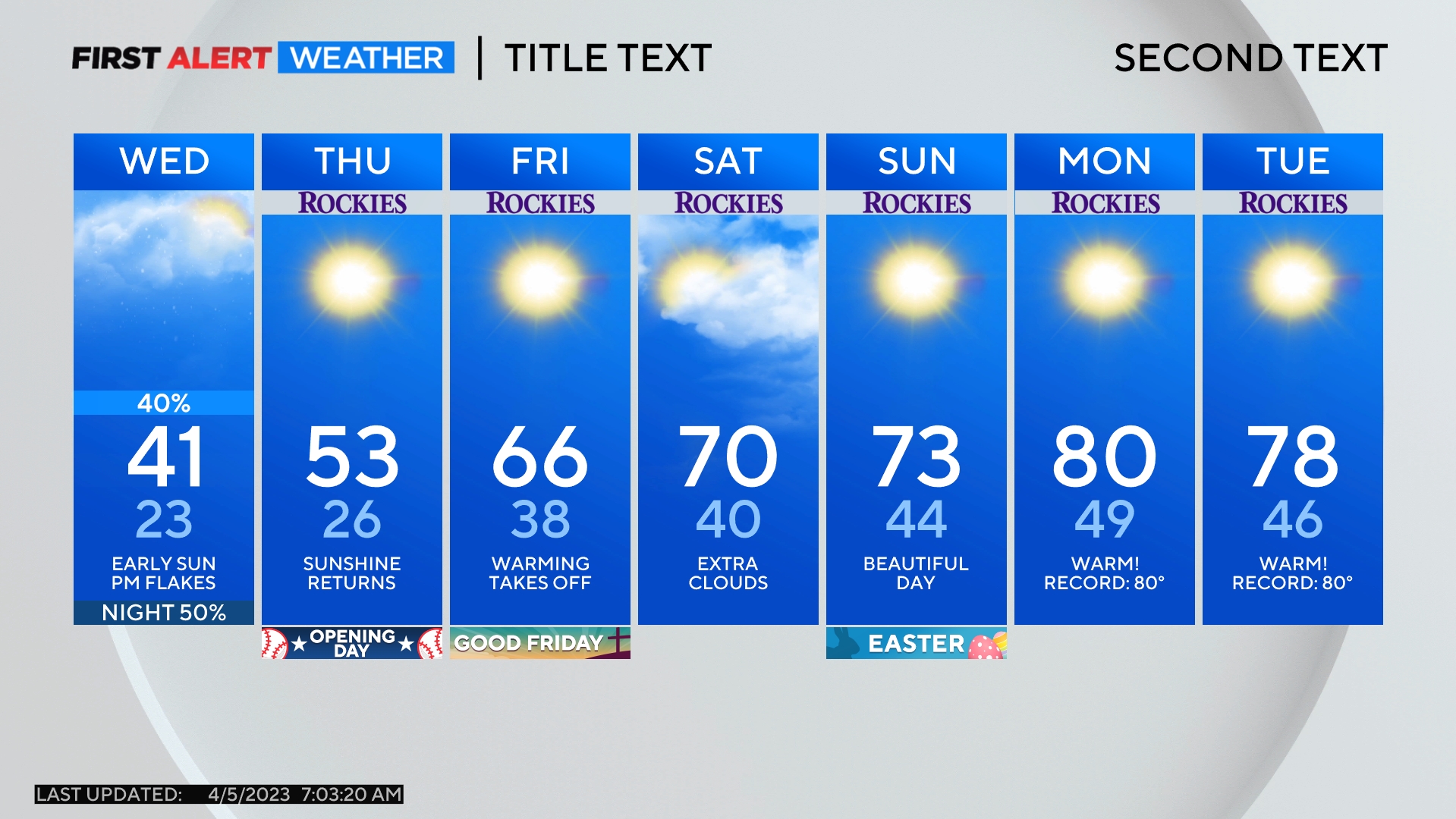
This storm will also bring much cooler weather to the Front Range on Wednesday and Thursday. Friday will start chilly before sunny skies allows for a warming trend Friday afternoon through the first day of spring on Sunday.