Colorado prepares for spring storm: up to 50" of snow on Pikes Peak, heavy rain in Denver and travel chaos in the high country

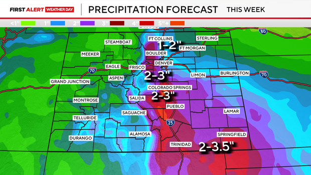
Spring slop will continue to spread across Colorado. Several inches of rain are possible in Denver and the foothills between Monday and Wednesday.
Perhaps the most impressive statistic is the 50 inches of snow expected to fall atop Pikes Peak by Thursday morning.
Precipitation will spread across the state Monday afternoon and evening. Showers will be spot's spotty across the foothills and Plains. Rain and snow showers are expected across the high country, with the rain/snow line remaining around 10,000 feet. I'd plan on winter travel at and above mountain pass level for Monday.
A lull is expected overnight Monday into early Tuesday. Rain and snow will waste no time spreading across the state, with steady rain arriving by 8-9 AM in Denver. This round of moisture will linger through the day on Wednesday. Widespread 1-3 inches of rain is expected across the foothills and Eastern Plains, much-needed drought-busting moisture.
Tuesday will be a "fun" day across the high country. Heavy, wet, altitude-dependent snow is expected, and a lot of it. This is typical for spring in Colorado, where a few hundred feet in elevation can mean the difference between 1-2 feet of snow and plain rain for some. If this impacts you, your commute, vacation, or other plans, please read on.
Let me start with what we know with a high degree of confidence: The San Juan, Sangre de Cristo, Sawatch Ranges, and Front Range Mountains will be hammered with wet, heavy snow. These impressive snow totals (below) will bring significant impacts to high-country travel.
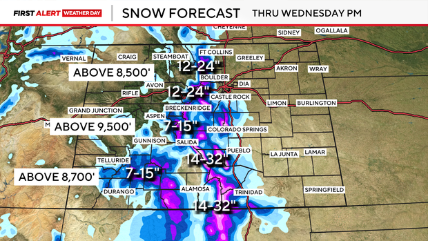
The biggest change to the forecast is pulling heavy snow down to about 7,500 feet. This means areas such as Conifer, Aspen Park, and Bailey will now likely see 6-12 inches. Areas such as Woodland Park and Divide are now also expecting anywhere from 10-15 inches of snow.
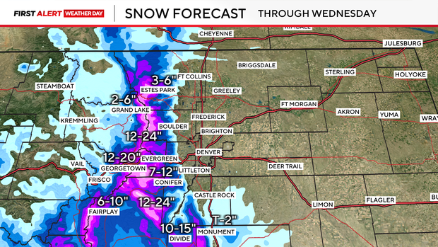
By Tuesday evening into the Wednesday morning commute, I'd plan on significant travel disruptions across the high country, including major delays and possible closures on I-70, Loveland Pass, and Berthoud Pass. For example, Georgetown to the Eisenhower-Johnson Tunnels is expecting 14-20 inches of snow.