Lake-effect could top 6 inches in Northwest Indiana; snow squall stalls Chicago morning commute


Northwest Indiana could see over six inches of lake-effect snow by Thursday morning, while a snow squall snarled Chicago's Wednesday morning commute.
The squall produced sudden white-out conditions, creating dangerous conditions on roads and highways, with reduced visibility and strong winds gusting up to 40 miles per hour. In some areas Wednesday morning, it wasn't even possible to see across the street.
Snow squalls are sudden cold weather events involving a quick burst of heavy snow and gusty winds, dropping visibility but rarely lasting longer than an hour. The snow had moved out of the city by midday.
But in Northwest Indiana, it's a different story. There, weather alerts are in effect through mid-afternoon in some areas and midday-Thursday in others. Lake effect snow could drop more than six inches in some places.
A Winter Weather Advisory is in effect from 8 a.m. Wednesday until 9 a.m. Thursday for Porter County, Indiana.
For LaPorte County, Indiana, and other parts of northern Indiana and southwest Michigan, a Winter Storm Warning is in effect until noon Thursday. Heavy lake-effect snow is expected in these areas, with accumulations of 6 inches to a foot.
Locally higher amounts are possible, especially in Berrien County, Michigan, according to the National Weather Service.
A separate Winter Weather advisory is in effect for southeast and south central Wisconsin — including Kenosha, Milwaukee, and Madison. CBS 58 in Milwaukee reported conditions in southeast Wisconsin were abysmal Wednesday morning — with the snow affecting visibility, and especially with temperatures dropping so wet roads froze over.
Sudden snow squall creates problems on roads, at airports
The snow was to blame for numerous crashes on Chicago area roadways Wednesday morning, and left traffic at a standstill on major arteries. As of the 9 a.m. hour, two center lanes of the Tri-State Tollway (I-294) were blocked by a crash near I-290. Two center lanes on the Tri-State were also blocked by a crash near Cicero Avenue in Alsip.
Meanwhile, a ground stop was in effect at O'Hare International Airport until 8:45 a.m. because of the snow. A total of 20 flights had been canceled at O'Hare as of 9:43 a.m. Wednesday, and delays were averaging 23 minutes. No cancellations were reported at Midway.
The conditions Wednesday morning were blamed for numerous crashes in southern Wisconsin. I-94 west was shut down for a crash near Oconomowoc going toward Madison, CBS 58 reported.
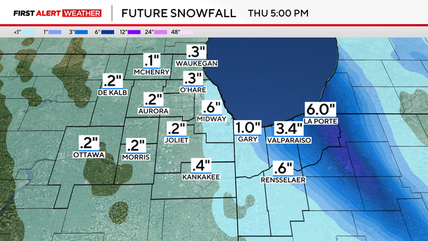
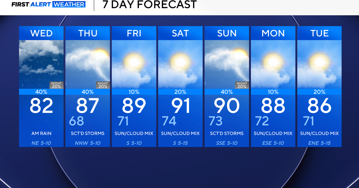
Snow totals
Expected snow totals vary widely throughout the area, with only .1 inch in McHenry; .2 inch in DeKalb, Aurora, Joliet, Ottawa, and Morris; .3 inch at O'Hare International Airport, and .6 inch at Midway International Airport and Rensselaer, Indiana. But a total of 1 inch is expected in Gary, while 3.4 inches are expected in Valparaiso, and 6 inches in LaPorte.