Blizzard conditions possible across portions of Colorado, rain transitioning to snow in Denver

A mild start to Monday with rain, snow, and wind expected by the evening. Significant accumulations are possible for portions of the high country, Palmer Divide, and Eastern Plains.
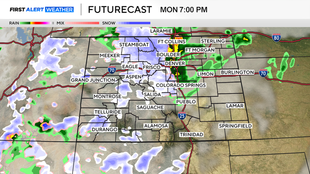
Monday will get off to a calm and sunny start with high temperatures in the 60s and 70s across the Plains. Rain showers will spill across I-25 after 1 PM. Temperatures will be far too warm for any rain to change to snow until at least 6 PM.
This is a classic spring storm in Colorado. The exact track is still up in the air, which will determine whether we get a huge storm across the Palmer Divide and Plains or just a few inches.
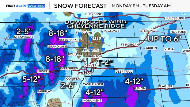
Temperatures are marginal, which means the snow will be wet and heavy—the back-breaking stuff. It also means a stronger storm track will be needed for most of us to even transition to snow. Think of it like this: when large amounts of water fall, it will absorb heat from the environment as it evaporates. This process cools the surface. A weaker storm will result in lighter precipitation and milder temperatures.
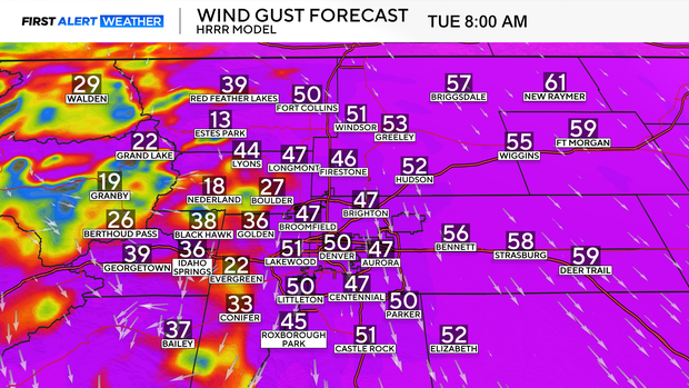
An interesting aspect of this storm will be the winds. Confidence is very high that strong winds will arrive by Monday night and linger through much of the day on Tuesday. Sustained winds of 30-40 MPH with gusts up to 55 MPH are expected along I-25, and 70 MPH for the far Eastern Plains.
A big question mark regarding how impactful the winds will be is snow accumulation. If this storm takes the snowier track, blowing snow combined with the winds will create blizzard conditions at times across the Palmer Divide, I-70 east of Denver, and portions of I-76.
Be sure to stay tuned as the forecast continues to evolve.


