Strong storms bring hail, damaging wind, flooding rain to Chicago area


CHICAGO (CBS) — Multiple rounds of storms hit the Chicago area Tuesday, with a powerful round in the afternoon bringing large hail, damaging winds, and possible tornadoes in some areas.
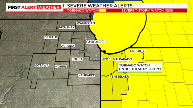
The National Weather Service issued a tornado warning for LaPorte County, Indiana, Tuesday afternoon, after a strong storm capable of producing a tornado was spotted near Michigan City, moving northeast at 45 mph.
A tornado warning also was issued earlier for Boone and McHenry counties in Illinois, but that warning expired at 2:30 p.m.
Multiple severe thunderstorm warnings also were issued in the city, suburbs, and northwest Indiana during the mid-afternoon hours.
Strong winds, reaching 60 mph to 70 mph, drove through southern Cook County and into the South Side of Chicago around 2:30 p.m.
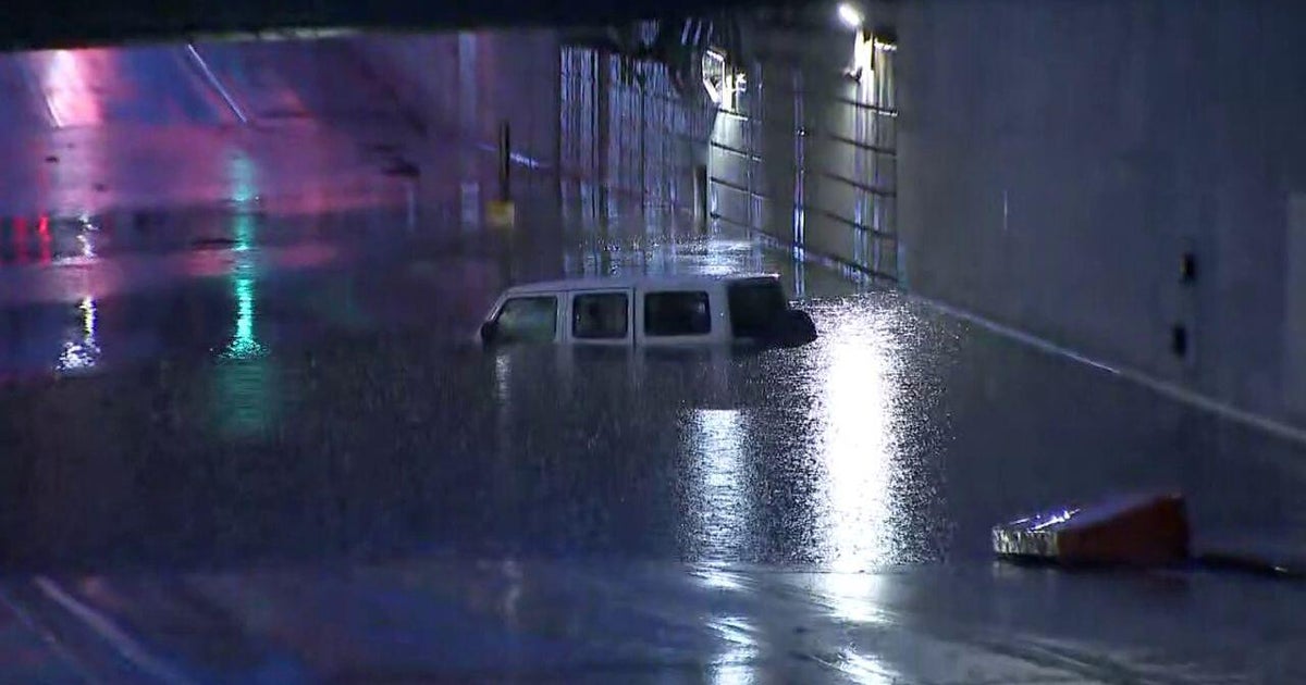
Drenching rain left the northbound lanes of Interstate 57 flooded near Halsted Street on Tuesday afternoon. While most drivers were stopped on the expressway around 4 p.m., several cars drove through water several inches deep.
Police eventually shut down the expressway, until the water receded. But traffic was backed up on northbound I-57 from Halsted Street all the way to 127th Street even after the expressway was reopened.
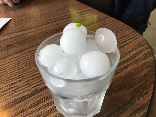
Tinley Park saw golf-ball-sized hail and Orland Park saw ping-pong-sized hail, according to the National Weather Service. Midway International Airport saw nickel-sized hail. In Palos Heights, so much hail fell that it looked like a pile of snow on the ground.
Back in Orland Park, winds also gusted up to 50 or 60 mph during the storm. Elsewhere in the southwest suburb, people were seen wading through the water as flooding turned streets into rivers.
Some intersections had two feet of water, and some people had to be rescued. Even longtime residents like John Welcome were surprised – he said such flooding has not been seen in Orland Park in 28 years.
"The rain came down so heavy, and then there was the hail with it – about 2 inches of hail with it," Welcome said. "It flooded in '96 like this – it flooded heavy in '96, and I remember we had kind of a big flood at that time, but yeah, this is the first time it's real bad again."
Trees come down in Indiana, barn collapses near Wisconsin state line
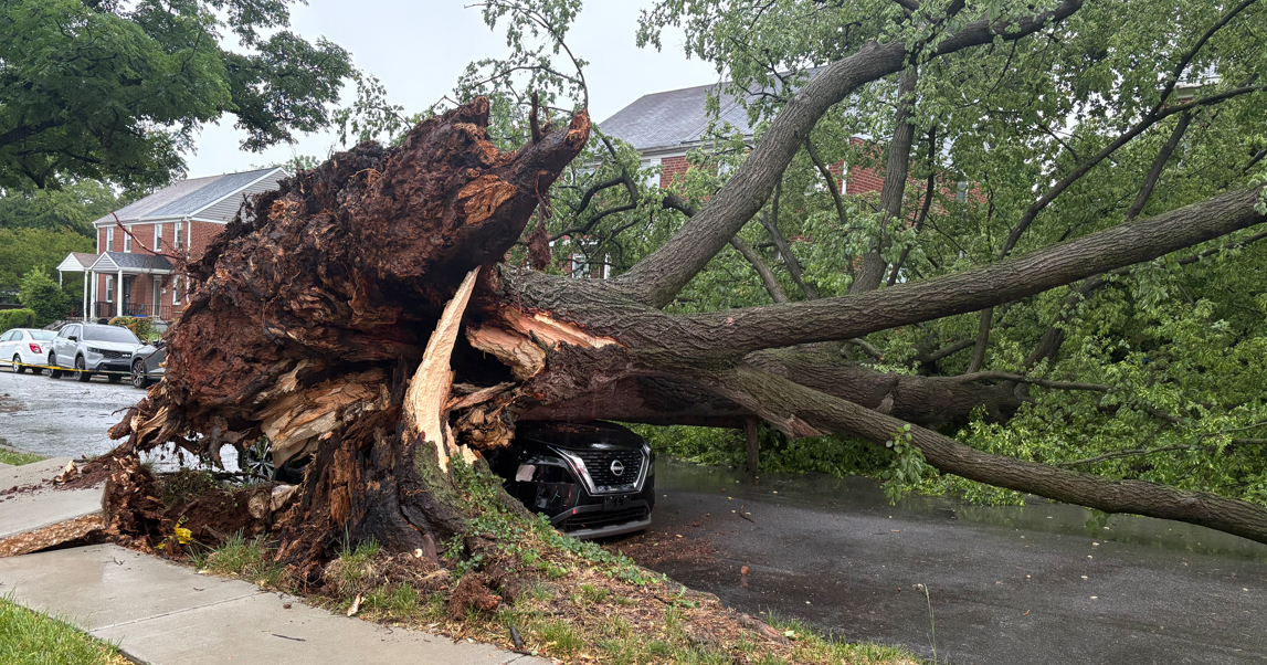
In Porter, Indiana, the storm tore branches off trees – with one causing a power line to smoke. Crews were on the scene early Tuesday evening restoring power to homes and businesses.
Gusty winds also uprooted large trees in Hobart, Indiana – with some landing on houses or cars. A backyard trampoline was left flipped on its side.
And in Chesterton, Indiana, a tree was uprooted and landed on the house where Melissa Bergner and her family live.
"My husband yelled, 'Babe, tree!' and next thing you know, you heard it hit," Bergner said.
The tree crushed the aluminum siding on the chimney, exposing the wood frame and pink insulation fiber to the street.
The weather was also believed to be to blame for the collapse of a barn in McHenry County. The livestock barn collapsed in the 10800 block of Weidner Road in unincorporated McHenry County outside Harvard, just south of the Wisconsin state line.
Firefighters successfully rescued 24 sheep, 18 goats, one cow, and several chickens and ducks. But four animals did die, and two remained unaccounted for late Tuesday.
There were no reports of human injuries.
A tornado watch that had been in effect for much of the afternoon in most of the Chicago area was cancelled for several counties in Illinois by 4:30 p.m., but remained in effect for Benton, Jasper, Lake, Newton, and Porter counties in Indiana until 8 p.m.
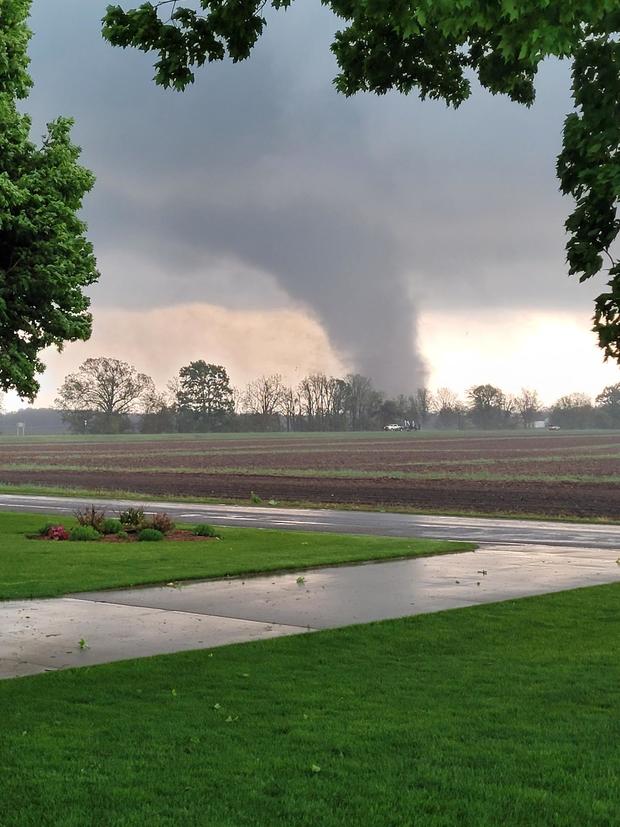
Tornadoes touch down in Western Michigan
Two tornadoes touched down in Michigan south of Kalamazoo as the storm system moved eastward. One touched down in St. Joseph County, near Mendon, and was deemed extremely large and dangerous. The other touched down in Van Buren County, near Decatur, Michigan, CBS affiliate WWMT-TV reported.
In Portage, Michigan, just south of Kalamazoo, a strip mall was ripped apart by an apparent tornado. Crews on the ground said all six businesses – including a barbershop and a pizza restaurant – were destroyed.
The entire strip mall will have to be torn down.
The FedEx building in Portage, Michigan, also collapsed due to the suspected tornado that touched down, WWMT reported.
The building was littered with debris, and flooded as well. There were reports that people were trapped inside, but the City of Portage said all employees were accounted for and safe.
Back in the Chicago area, another storm system passed through in the evening. A larger storm system also hit the Milwaukee area Tuesday night.
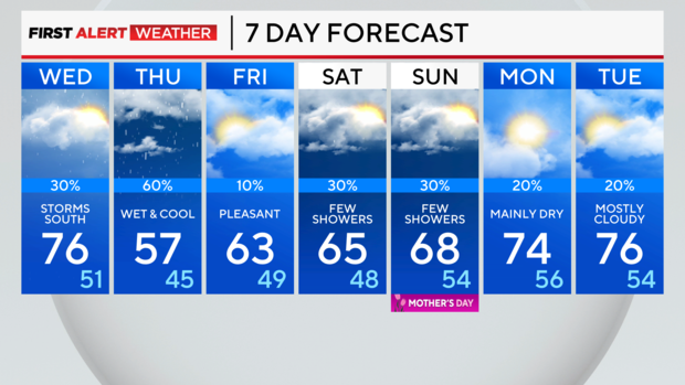
Showers return late in the day on Wednesday, and widespread showers and thunderstorms will be back in the area overnight Wednesday into Thursday. The severe weather threat is a level 1 out of 5.
Cooler weather blows in on Thursday.
Tonight: An isolated storm is possible. Low: 55
Tomorrow: Mostly cloudy with an isolated thunderstorm. High: 76
Thursday: Cloudy and cooler with periods of rain. High: 57