Chicago snow squalls Friday morning, Northwest Indiana expecting heavy lake effect snow this weekend


Friday morning snow squalls in the Chicago weather forecast could make the commute extremely dangerous before Northwest Indiana gets clobbered by lake effect snow this weekend.
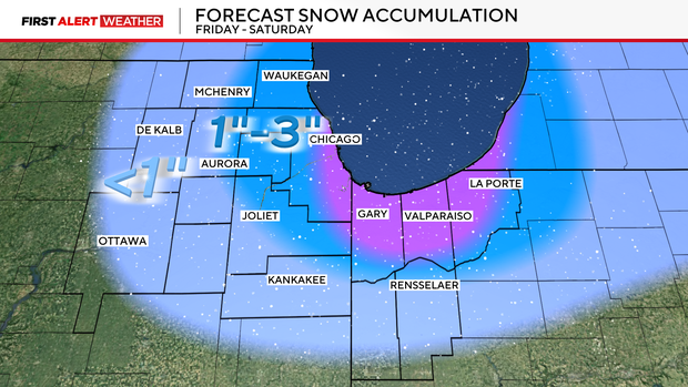
The squall is expected to hit during the morning commute, dropping 1 to 3 inches and creating dangerous whiteout conditions when roads are at their busiest.
A Winter Weather Advisory has been issued for Cook, DuPage and Lake counties in Illinois from 9 a.m. to 3 p.m. Friday.
A Winter Storm Watch is in effect for central and southern Cook County in Illinois from 3 p.m. Friday through 12 a.m. Saturday.
A Winter Storm Warning has been issued for Lake and Porter counties in Indiana from 3 p.m. Friday until 6 p.m. Saturday.
CBS News Chicago Chief Meteorologist Albert Ramon said a snow squall with gusty winds and low visibility is expected to move into the city around 9 a.m. off Lake Michigan, hitting first along the North Shore before making its way to the south suburbs in the afternoon.
While most of the city will see 1 to 3 inches in snow totals, there could be localized 6-inch totals from the Loop to Bronzeville, then southeastward toward Calumet City. Those areas could see snow totals up to 6 inches.
Snow squalls are fast-moving, localized winter weather events in which high winds and sudden snow create extremely dangerous whiteout conditions on roads, and often lead to car crashes and spinouts. Morning traffic will be slow, Yeomans said, and residual traffic delays could last through midday.
Friday evening, a heavy band of lake effect snow could bring snowfall rates of 2 to 3 inches per hour in Northwest Indiana, making for dangerous travel conditions.
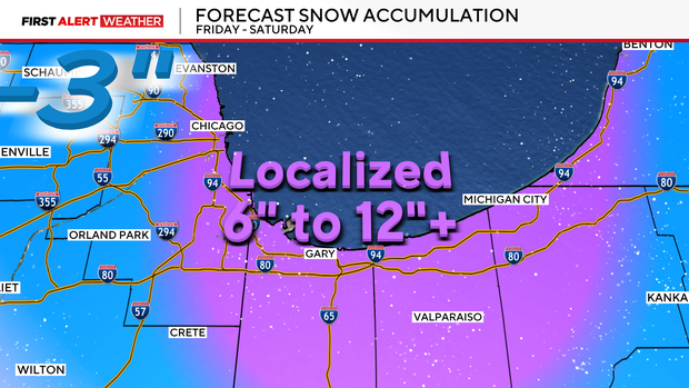
Northwest Indiana will see its heaviest snow Friday night into Saturday morning. A Winter Storm Watch is in effect; 6 to 12 inches of snow is expected widely, and travel conditions will be very dangerous.
Lake and Porter counties in Indiana are expected to see 6 to 12 inches of snow with isolated higher amounts.
Saturday the snow will move back westward into Chicago for another round, but it will be much lighter and taper off by afternoon.
There are more clipper systems in the forecast on Monday and Wednesday of next week, which are expected to produce widespread but generally light snowfall totals.