Tracking Isaias: Damaging Winds, Elevated Risk Of Tornadoes In Southern New England
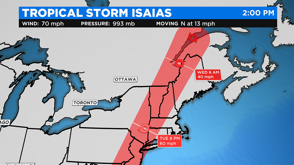
BOSTON (CBS) - Hurricane Isaias was downgraded to a tropical storm Tuesday after making landfall in North Carolina overnight.
As is often the case with tropical systems riding north up the East Coast, Isaias will begin to accelerate as it approaches the northern Latitudes (our region).
Tracking Maps: Tropical Storm Isaias
It will finally feel the tug of a true steering current (a digging jet stream to our west) and will literally be in and out of here in all of about 6 hours Tuesday night.
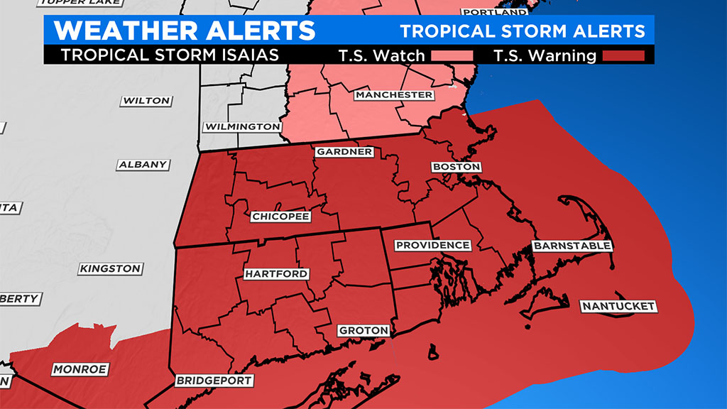
Even though the track of the storm will be well to our west, passing near the MA/NY border Tuesday night, the east side of the storm will still pack a bit of a wind punch in our area. The combination of a digging jet stream and an accelerating storm (you can generally add the forward speed of a tropical system on to the peak wind gusts on the east side), will bring a 6 hour period of very gusty, damaging winds to southern New England.
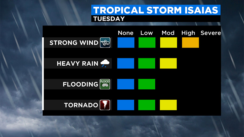
Let's break down the impacts piece by piece.
RAIN:
The heaviest rainfall with tropical systems is nearly always to the west of the track, Isaias will be no different. Therefore, western MA and New York State will be the bullseye for as much as 3-5" of rainfall Tuesday night. In central and eastern MA, we are looking at likely less than an inch of rainfall, with some areas along the Coast getting nearly nothing...certainly not a drought buster for us.
SEVERE WEATHER:
Another common theme with tropical systems, severe weather. Again, being on the east side of the track, leaves southern New England in a vulnerable area for some severe thunderstorms Tuesday afternoon and evening. There is also an elevated risk of a few quick, spin-up type tornadoes, particularly in Connecticut and areas southwest of Boston.
WIND:
Our biggest concern and largest overall impact from Isaias will be from the wind. It won't last long, but we are expecting a 3-6 hour window with wind gusts 35-65mph across all of southern New England. Expect peak winds between about 5p-11p Tuesday evening.
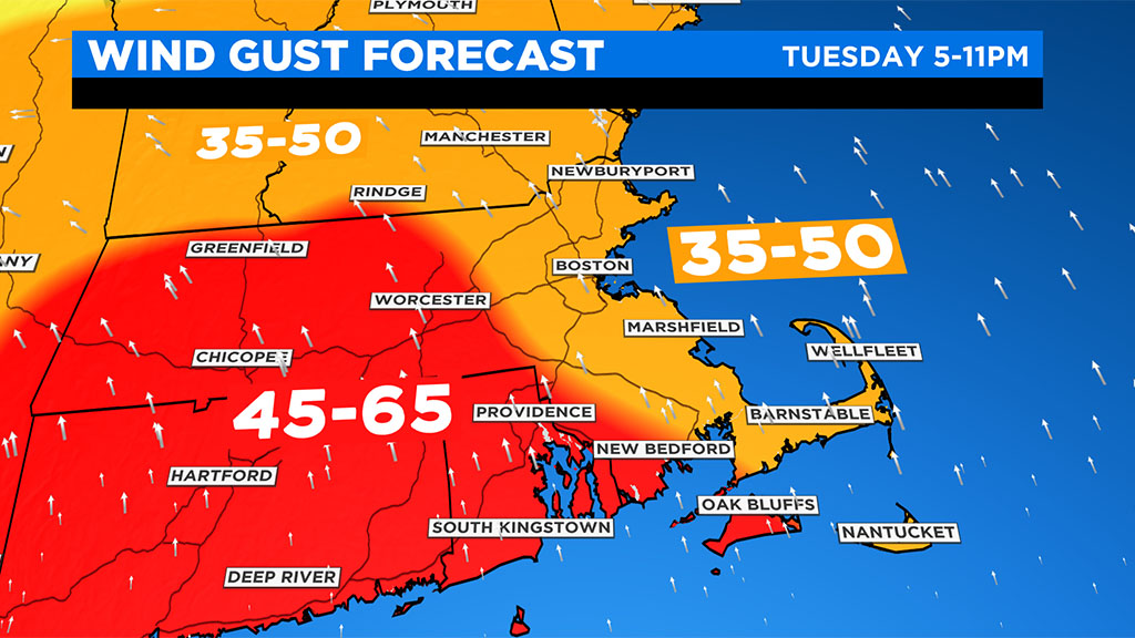
Strongest winds will occur closer to the center of Isaias; through Connecticut and central and western Massachusetts, where gusts to 65mph could be quite common. Farther to the east, closer to Boston, winds should top out around 50-55mph. This will certainly be enough to create some downed trees and power outages. Any loose (light) outdoor furniture, trash barrels etc should be secured before tomorrow evening.
COASTLINE:
Not anticipating any coastal flooding in our area with Isaias. The seas will certainly be churned up though, with large swells and wave heights reaching 10-15 feet just offshore to the south of the Cape, Islands and South Coast. Rip currents will be an issue for several days following the passage of the storm.
Got plans Wednesday? You should be good to go! Isaias will be long gone by dawn on Wednesday, and then it is back to the sunshine and warmth for the next several days.
Of course, we urge that you stay tuned to updated forecasts on WBZ-TV, CBSBoston.com and CBSN Boston throughout the storm. We will keep you updated will all the latest important information.


