Memorial Day Weekend Weather Looking Warm, Wet
The Memorial Day Holiday Weekend begins today and we all crave cooperative weather to get outside and enjoy a veritable potpourri of activities from graduations to parties to weddings to road races, biking, golf, hiking etc.
Typically, the weather becomes less forecastable for an extra long weekend and this one is no exception so Murphy's Law applies. Overall, however, there is reasonable confidence on the general ideas of the prediction but there are some lingering tidbits of uncertainty.

Timing Issues
The wavy weather front bisecting New England will be oscillating through the weekend. It will be the key factor in changing the temperatures especially over the coastal plain. This quasi-stationary front will become a warm frontal boundary and start advancing northeastward through the region today so the coast will warm up later this afternoon when the wind becomes more southeast to southerly. Most of the region will be in the warm and increasingly humid sector tomorrow. This front will transition into a cold frontal boundary late tomorrow as the cooler air starts advancing southward across extreme northern New England. The present timing suggests that the so-called "back-door front" will transit west-southwestward across eastern MA Sunday morning introducing the cooler air from the Atlantic.


Temperatures
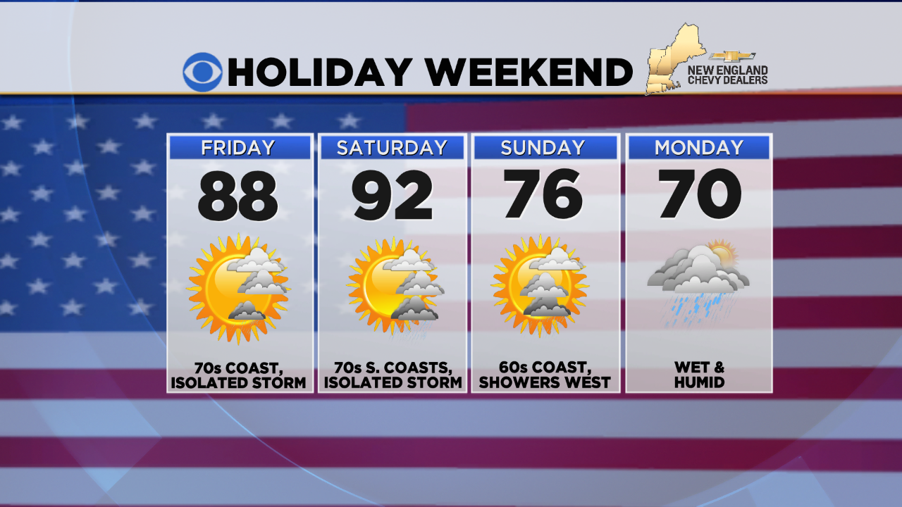
The hottest day of the weekend will be tomorrow as near record high temperatures are possible. The record high for Boston is 92 set in 1931. This will be the city's first day at 90 or higher since September 9 which was 252 days ago. On average, Boston's first 90 of the season occurs on June 8 and the number of days at 90 or higher per season is 13. BTW, I am expecting closer to 22-24 such days this summer! With the frontal passage pegged early in the day, coastal temperatures will likely remain in the 60s in the morning and perhaps even fall closer to 60 as the afternoon progresses. Farther inland, it may warm up to the middle to upper 70s then retreat to the lower 70s in the afternoon as the cool ocean wind of 10-20 mph penetrates farther inland. Warmest weather will exist from western Worcester County westward. On Memorial Day, temperatures will rise from the 50s early in the day to 68-71 at mid-afternoon.
Wind
A southwesterly wind of 10-20 mph will blow across the area tomorrow. A shift to northeast to easterly starts early Sunday at similar speeds or even a bit higher to 25 mph or so along the coast. It will shift again back to a south-southwesterly direction at 10-20 mph on Monday.
Humidity

You will feel the spike in humidity tomorrow as the dew points creep into the high range above 65 degrees. With the cooler air surging in from the Maritimes on Sunday, the dew points will drop back to the low range in the 50s. They will rise back toward the high range on Monday as tropical moisture flows into the Northeast. This will be swept out to sea Monday night & Tuesday.


Showers & Thunderstorms
A few may be scattered around the area Saturday afternoon and evening then most of the support for an outbreak of activity exists across western New England on Sunday primarily in the afternoon. The highest risk of rain occurs on Memorial Day with showery rains and spotty thunder more widespread. This action will move away as a cold frontal boundary pushes eastward and off the coast Monday night.

The Monday moisture will be produced by the delivery of a moist conduit connected with the tropical disturbance currently east of the Bahamas. This system has the potential to evolve into the second tropical cyclone of 2016. It will be named Bonnie. Alex already occurred as the first hurricane to form in the month of January since 1938. Alex was way out near the Azores. Bonnie is beamed toward the South Carolina coast as a tropical storm with winds perhaps up to 50 or so mph. The National Hurricane Center will issue statements on the progress of potential Bonnie as the weekend progresses. We could experience some tropical downpours on Monday.
Coast & Mountains


Weekend high tides start just after 4pm today, 5pm tomorrow, just before 6pm Sunday and just before 7pm on Monday. Seas will run 2 up to 4 feet this weekend with ocean temperatures mainly in the 50s.
Have A Happy & Safe Holiday Weekend And Remember Its True Meaning.