Downpours in Massachusetts could impact Ghana vs England World Cup match in Foxboro


The WBZ-TV Weather Team has issued a Next Weather Alert for one of the better soakings of rainfall we've had in Massachusetts since St. Patrick's Day weekend.
Much of the South Coast dealt with flash flooding early Tuesday because of heavy rain overnight. In Fall River, where 3.85 inches fell, some streets were flooded, but the water receded after sunrise.

Cloudy skies and additional rain chances for Tuesday cannot be ruled out as the frontal boundary continues to pass east and some moisture lingers behind.
Additionally, the cloud cover and rain-cooled air are likely to keep temperatures below average, similar to Monday.
Expect one more round of scattered rain pushing through Tuesday evening into the first half of the night.
Massachusetts Weather Radar
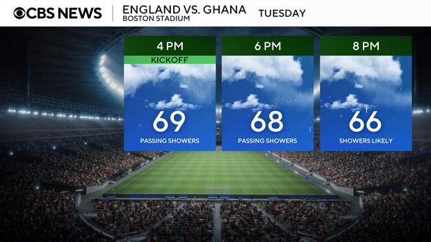
The rain could also impact the England vs. Ghana World Cup match in Foxboro at 4 p.m. The conditions at Boston Stadium will remain murky and raw with temperatures in the 60s and humid.
The forecast improves Wednesday and Thursday with more sunshine and temperatures in the 80's.
While not ending the drought, the rain will help alleviate some of the dry conditions and give lawns and gardens a chance to recover a bit.
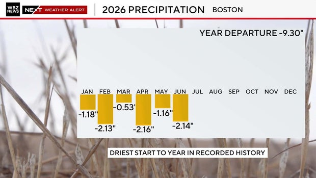
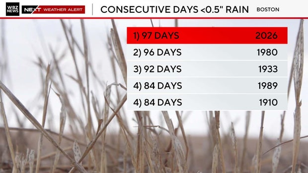
Boston has had its driest start to a year on record and has also gone the longest on record without seeing a single half-inch rainfall event.
Most of the area is roughly 10-to-20 inches below average for rainfall over the past year, with Nantucket more than two feet below average.


