March starts meteorological spring, but winter weather isn't gone yet
By Terry Eliasen, WBZ-TV Meteorologist, Executive Weather Producer
BOSTON - Happy meteorological spring! If you look at your calendar, undoubtedly, it says spring begins on March 20th. But, if you ask a meteorologist or climatologist, they will tell you spring arrived Wednesday!
We classify the seasons in three-month chunks:
Winter: (Dec-Jan-Feb)
Spring: (Mar-Apr-May)
Summer: (Jun-Jul-Aug)
Fall: (Sep-Oct-Nov)
This makes data assembly and comparison much simpler.
So, it only makes sense that we take a few minutes to look back at this past winter and, take a brief look ahead at what may be to come.
No surprise or breaking news here - this winter was warm.
Here are the rankings for each month in Boston:
December: 27th warmest
January: 5th warmest
February: 16th warmest
Put it all together and Boston had its fifth warmest winter on record. Worcester's ranked number one.

It isn't just the daytime highs that are unusually warm, the nights have been even more dramatic! Boston had its fewest number of nights below 30 degrees on record this winter.
Looking month by month, you can see that each month was both warmer than the average and had significantly less snow than average in both cities.
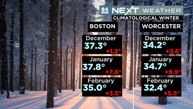
Both cities are more than 2 feet below the average snow to date.

So, this begs the question - will this pattern continue into spring? The short answer is no.
Typically, Boston sees about 9 inches of snow in March, although, it has been several years since we had any significant snow occur this month. Average temperatures rise about 8 degrees throughout the month and, perhaps the best news of all, we turn the clocks ahead on the 12th and have sunsets after 7 p.m. by the end of the month.
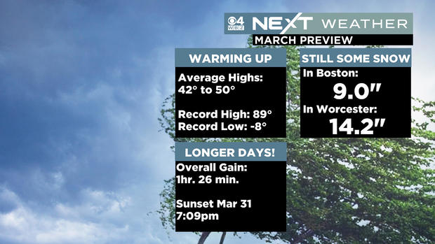
We have had some very mild and "easy" Marchs in recent years, so I guess you could say we are "due."
Take a look at the forecasted temperatures over the next few weeks and for the month as a whole.
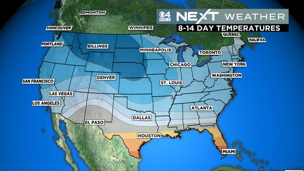
Most of the country, especially the northern tier, looks cold. This is something we just haven't seen at all this winter.
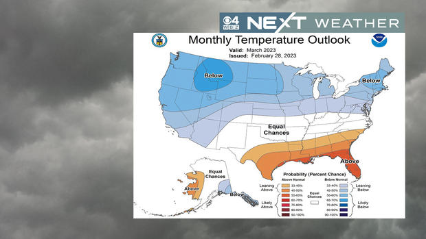
Combine the colder temperatures with an active storm track and you have a recipe for a very busy, wintry month. We will likely have several chances at snow or a wintry mix in the days and weeks ahead, starting with Friday night into Saturday. We're still working out the fine details, but it appears that we are in for a variety of precipitation in southern New England early on Saturday.
Beyond that, next week looks colder than average and fairly dry and quiet to start. The overall pattern for the next few weeks is far from quiet. There will be a "parade of storms" coming to the west coast and marching across the country. Many of these will likely find their way to us in the northeast and run into a cooler than average airmass.
I feel for those hoping to get out on the soccer or baseball fields this month. Even if we don't get a lot of snow, the pattern looks active and wet, likely extending and exacerbating the "mud season" well into April.


