Hurricane Erin to bring rip currents, 5-to-20 foot waves to some Massachusetts beaches

Hurricane Erin may be far out into the Atlantic Ocean, but it's having an impact on the coast of Massachusetts.
As of Thursday morning, Erin remains a strong and highly impactful Category 2 storm. It will not be making a direct hit on southern New England, but the region will see secondary impacts from Erin's outward wind field.
High surf advisory
As a result, the National Weather Service has extended a High Surf Advisory along south-facing beaches through Saturday. Some will expire during the morning while others continue through the evening.
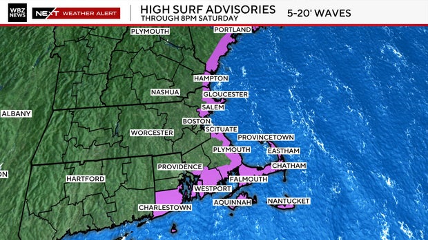
The WBZ-TV Weather Team is forecasting waves between 8 and 13 feet along most of those beaches. This would include the south side of Nantucket and Martha's Vineyard as well as the South Coast of Massachusetts (Plymouth and Bristol counties) and Rhode Island.
There will also be a high risk of dangerous rip currents over the next several days so swimming in the ocean is not recommended at this time.
Hurricane Erin wind forecast for Massachusetts
Hurricane Erin has maximum winds of 110 mph, with pressure lowering to 945 mb. The official National Hurricane Center track places the center of Erin about 350 miles from the Cape and Islands at its closest pass by New England early Friday.
While this may seem like a large distance, we expect Erin's wind field to expand in size as it travels farther north. This is a common occurrence as tropical systems move through northern latitudes.
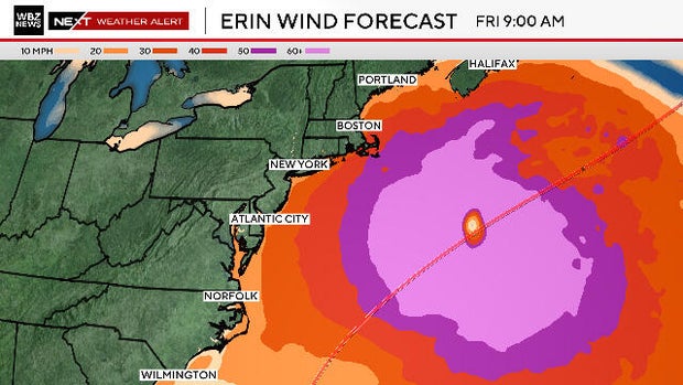
Locally, the strongest winds will be over extreme southeastern Massachusetts, particularly Cape Cod, Martha's Vineyard and Nantucket. East-northeast winds will gust 30 to 50 mph in that area from late Thursday through a good portion of Friday.
Farther inland, it will be breezy on Thursday and Friday, but nothing all that concerning.
There will be some minor coastal flooding and inundation during the high tide periods in the coming days.
As Erin moves beyond our latitude, winds will shift to the northeast and then north on Friday. Therefore, there could be some minor flooding or splash over at northeast or east facing beaches during the Friday late-morning tide cycle.
Erin will be long gone by this weekend, and we expect another sunny Saturday. If you are heading to the beach, beware that the seas will take time to relax and there will be some lingering impacts.